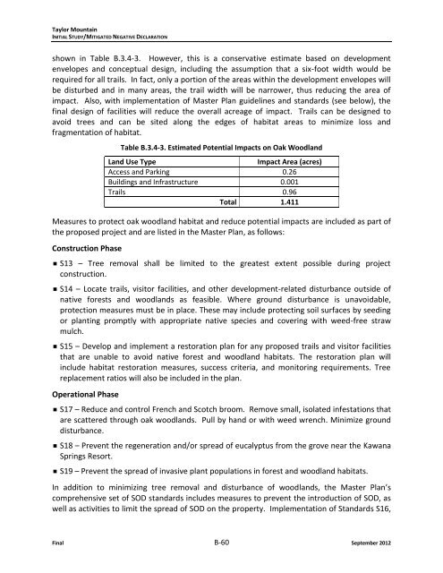
Taylor MountainINITIAL STUDY/MITIGATED NEGATIVE DECLARATIONshown in Table B.3.4-3. However, this is a conservative estimate based on developmentenvelopes <strong>and</strong> conceptual design, including the assumption that a six-foot width would berequired for all trails. In fact, only a portion of the areas within the development envelopes willbe disturbed <strong>and</strong> in many areas, the trail width will be narrower, thus reducing the area ofimpact. Also, with implementation of Master Plan guidelines <strong>and</strong> st<strong>and</strong>ards (see below), thefinal design of facilities will reduce the overall acreage of impact. Trails can be designed toavoid trees <strong>and</strong> can be sited along the edges of habitat areas to minimize loss <strong>and</strong>fragmentation of habitat.Table B.3.4-3. Estimated Potential Impacts on Oak Woodl<strong>and</strong>L<strong>and</strong> Use TypeImpact Area (acres)Access <strong>and</strong> Parking 0.26Buildings <strong>and</strong> Infrastructure 0.001Trails 0.96Total 1.411Measures to protect oak woodl<strong>and</strong> habitat <strong>and</strong> reduce potential impacts are included as part ofthe proposed project <strong>and</strong> are listed in the Master Plan, as follows:Construction Phase S13 – Tree removal shall be limited to the greatest extent possible during projectconstruction. S14 – Locate trails, visitor facilities, <strong>and</strong> other development-related disturbance outside ofnative forests <strong>and</strong> woodl<strong>and</strong>s as feasible. Where ground disturbance is unavoidable,protection measures must be in place. These may include protecting soil surfaces by seedingor planting promptly with appropriate native species <strong>and</strong> covering with weed-free strawmulch. S15 – Develop <strong>and</strong> implement a restoration plan for any proposed trails <strong>and</strong> visitor facilitiesthat are unable to avoid native forest <strong>and</strong> woodl<strong>and</strong> habitats. The restoration plan willinclude habitat restoration measures, success criteria, <strong>and</strong> monitoring requirements. Treereplacement ratios will also be included in the plan.Operational Phase S17 – Reduce <strong>and</strong> control French <strong>and</strong> Scotch broom. Remove small, isolated infestations thatare scattered through oak woodl<strong>and</strong>s. Pull by h<strong>and</strong> or with weed wrench. Minimize grounddisturbance. S18 – Prevent the regeneration <strong>and</strong>/or spread of eucalyptus from the grove near the KawanaSprings Resort. S19 – Prevent the spread of invasive plant populations in forest <strong>and</strong> woodl<strong>and</strong> habitats.In addition to minimizing tree removal <strong>and</strong> disturbance of woodl<strong>and</strong>s, the Master Plan’scomprehensive set of SOD st<strong>and</strong>ards includes measures to prevent the introduction of SOD, aswell as activities to limit the spread of SOD on the property. Implementation of St<strong>and</strong>ards S16,Final B-60 September 2012
Taylor MountainINITIAL STUDY/MITIGATED NEGATIVE DECLARATIONS72 <strong>and</strong> S73 would involve education, physical construction practices, equipment cleaning, stafftraining, monitoring <strong>and</strong> other miscellaneous provisions to ensure potential SOD impacts areminimized to the maximum extent feasible.Implementation of the above measures would ensure that impacts on sensitive habitats are lessthan significant. As described above, with proper design <strong>and</strong> siting of facilities (primarily trails),impacts will be avoided or reduced to levels that are less than significant.c. Would the project have a substantial adverse effect on federally protected wetl<strong>and</strong>s asdefined by Section 404 of the Clean Water Act (including, but not limited to, marsh, vernalpool, coastal, etc.) either individually or in combination with the known or probableimpacts of other activities through direct removal, filling, hydrological interruption, orother means?LESS THAN SIGNIFICANT. Potential jurisdictional wetl<strong>and</strong>s, including vernal marsh, freshwaterseeps, <strong>and</strong> coastal <strong>and</strong> valley freshwater marsh, occur at several locations within the projectarea (Figure B.3.4-4, Potential Impact on Wetl<strong>and</strong>s <strong>and</strong> Waters). As described in the settingsection, the Taylor Mountain property contains several different types of wetl<strong>and</strong>s. Currently,wetl<strong>and</strong>s are used extensively by cattle due to their proximity to existing water troughs <strong>and</strong>availability as forage. Several existing public trails follow the edges of wetl<strong>and</strong>s. Most of thenon-native plant species that are present in wetl<strong>and</strong>s on Taylor Mountain are widelynaturalized both across the property <strong>and</strong> throughout California. Protecting water quality,quantity, <strong>and</strong> native vegetation around wetl<strong>and</strong>s will enable these special environments tocontinue to provide valuable hydrologic <strong>and</strong> habitat functions.Currently, during periods of wet weather, livestock <strong>and</strong> human visitors trample wetl<strong>and</strong>s,resulting in soil compaction, degraded water quality through elevated sedimentation <strong>and</strong>nutrient input from livestock waste, <strong>and</strong> impacts on native wildlife. Grazing is heaviest in thesouthwestern part of Taylor Mountain where water sources are most prevalent <strong>and</strong> topographyis gentle (Bush, 2012). Erosion from trampling <strong>and</strong> runoff from trails around marshes <strong>and</strong> seepscan increase sediment delivery into wetl<strong>and</strong> habitats <strong>and</strong> adjacent receiving waters. Impacts onwetl<strong>and</strong>s are problematic year round because common amphibians use them in the winter forbreeding but CRLF use them in the summer for non-breeding aquatic hydration habitat.Additionally, in-channel headcuts (vertical drops in the stream channel) have migratedupstream in several tributaries <strong>and</strong> have the potential to erode into <strong>and</strong> through some wetl<strong>and</strong>habitats.Implementation of improvements identified in the Master Plan will potentially have directimpacts on small areas of wetl<strong>and</strong>s <strong>and</strong> has the potential to cause indirect impacts on wetl<strong>and</strong>sas well. The proposed improvements have the potential to impact wetl<strong>and</strong>s directly throughground disturbance <strong>and</strong> construction. These direct impacts would occur through road <strong>and</strong>infrastructure development <strong>and</strong> trail <strong>and</strong> boardwalk construction. Potential impacts onfederally protected wetl<strong>and</strong>s total 0.13 acres <strong>and</strong> are illustrated in Figure B.3.4-4 <strong>and</strong> describedin Table B.3.4-4 below.September 2012 B-61 Final