

STREETSCAPE GUIDANCE
streetscape-guidance
streetscape-guidance

You also want an ePaper? Increase the reach of your titles
YUMPU automatically turns print PDFs into web optimized ePapers that Google loves.
HOME<br />
INTRODUCTION<br />
PART A<br />
A vision for London’s streets<br />
PART B<br />
From strategy to delivery<br />
PART C<br />
New measures for new challenges<br />
PART D<br />
Balancing priorities<br />
PART F<br />
Appendix<br />
PART E<br />
Physical design and materials<br />
SECTION 6<br />
Introduction<br />
SECTION 7<br />
High quality footways<br />
SECTION 8<br />
Carriageways<br />
SECTION 9<br />
Crossings<br />
SECTION 10<br />
Kerbside activity<br />
SECTION 11<br />
Footway amenities<br />
SECTION 12<br />
Safety and functionality<br />
SECTION 13<br />
Street environment<br />
SECTION 14<br />
Transport interchanges<br />
Streetscape Guidance<br />
3.7 Simplifying a junction<br />
[Part B] From strategy to delivery 30<br />
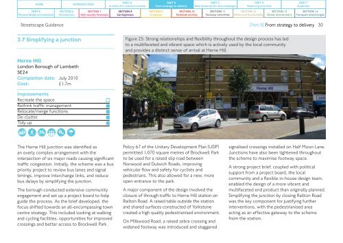
Figure 25: Strong relationships and flexibility throughout the design process has led<br />
to a multifaceted and vibrant space which is actively used by the local community<br />
and provides a distinct sense of arrival at Herne Hill<br />
Herne Hill<br />
London Borough of Lambeth<br />
SE24<br />
Completion date: July 2010<br />
Cost:<br />
£1.7m<br />
Improvements<br />
Recreate the space<br />
Rethink traffic management<br />
Relocate/merge functions<br />
De-clutter<br />
Tidy up<br />
Image courtesy of the London Borough of Lambeth<br />
The Herne Hill junction was identified as<br />
an overly complex arrangement with the<br />
intersection of six major roads causing significant<br />
traffic congestion. Initially, the scheme was a bus<br />
priority project to review bus lanes and signal<br />
timings, improve interchange links, and reduce<br />
bus delays by simplifying the junction.<br />
The borough conducted extensive community<br />
engagement and set up a project board to help<br />
guide the process. As the brief developed, the<br />
focus shifted towards an all-encompassing town<br />
centre strategy. This included looking at walking<br />
and cycling facilities, opportunities for improved<br />
crossings and better access to Brockwell Park.<br />
Policy 67 of the Unitary Development Plan (UDP)<br />
permitted 1,070 square metres of Brockwell Park<br />
to be used for a raised slip road between<br />
Norwood and Dulwich Roads, improving<br />
vehicular flow and safety for cyclists and<br />
pedestrians. This also allowed for a new, more<br />
open entrance to the park.<br />
A major component of the design involved the<br />
closure of through traffic to Herne Hill station on<br />
Railton Road. A raised table outside the station<br />
and shared surfaces constructed of Yorkstone<br />
created a high quality pedestrianised environment.<br />
On Milkwood Road, a raised zebra crossing and<br />
widened footway was introduced and staggered<br />
signalised crossings installed on Half Moon Lane.<br />
Junctions have also been tightened throughout<br />
the scheme to maximise footway space.<br />
A strong project brief, coupled with political<br />
support from a project board, the local<br />
community and a flexible in-house design team,<br />
enabled the design of a more vibrant and<br />
multifaceted end product than originally planned.<br />
Simplifying the junction by closing Railton Road<br />
was the key component for justifying further<br />
interventions, with the pedestrianised area<br />
acting as an effective gateway to the scheme<br />
from the station.