

SDI Convergence - Global Spatial Data Infrastructure Association
SDI Convergence - Global Spatial Data Infrastructure Association
SDI Convergence - Global Spatial Data Infrastructure Association

You also want an ePaper? Increase the reach of your titles
YUMPU automatically turns print PDFs into web optimized ePapers that Google loves.
sufficiently simple to allow representation in a relational data model. It is important that<br />
the storage mechanism for the catalogue is platform independent so that it can be easily<br />
replicated and XML is therefore attractive.<br />
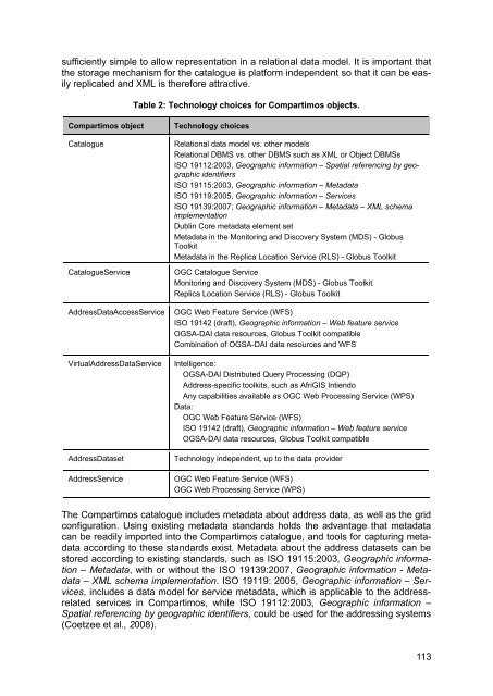
Table 2: Technology choices for Compartimos objects.<br />
Compartimos object Technology choices<br />
Catalogue Relational data model vs. other models<br />
Relational DBMS vs. other DBMS such as XML or Object DBMSs<br />
ISO 19112:2003, Geographic information – <strong>Spatial</strong> referencing by geographic<br />
identifiers<br />
ISO 19115:2003, Geographic information – Metadata<br />
ISO 19119:2005, Geographic information – Services<br />
ISO 19139:2007, Geographic information – Metadata – XML schema<br />
implementation<br />
Dublin Core metadata element set<br />
Metadata in the Monitoring and Discovery System (MDS) - Globus<br />
Toolkit<br />
Metadata in the Replica Location Service (RLS) - Globus Toolkit<br />
CatalogueService OGC Catalogue Service<br />
Monitoring and Discovery System (MDS) - Globus Toolkit<br />
Replica Location Service (RLS) - Globus Toolkit<br />
Address<strong>Data</strong>AccessService OGC Web Feature Service (WFS)<br />
ISO 19142 (draft), Geographic information – Web feature service<br />
OGSA-DAI data resources, Globus Toolkit compatible<br />
Combination of OGSA-DAI data resources and WFS<br />
VirtualAddress<strong>Data</strong>Service Intelligence:<br />
OGSA-DAI Distributed Query Processing (DQP)<br />
Address-specific toolkits, such as AfriGIS Intiendo<br />
Any capabilities available as OGC Web Processing Service (WPS)<br />
<strong>Data</strong>:<br />
OGC Web Feature Service (WFS)<br />
ISO 19142 (draft), Geographic information – Web feature service<br />
OGSA-DAI data resources, Globus Toolkit compatible<br />
Address<strong>Data</strong>set Technology independent, up to the data provider<br />
AddressService OGC Web Feature Service (WFS)<br />
OGC Web Processing Service (WPS)<br />
The Compartimos catalogue includes metadata about address data, as well as the grid<br />
configuration. Using existing metadata standards holds the advantage that metadata<br />
can be readily imported into the Compartimos catalogue, and tools for capturing metadata<br />
according to these standards exist. Metadata about the address datasets can be<br />
stored according to existing standards, such as ISO 19115:2003, Geographic information<br />
– Metadata, with or without the ISO 19139:2007, Geographic information - Metadata<br />
– XML schema implementation. ISO 19119: 2005, Geographic information – Services,<br />
includes a data model for service metadata, which is applicable to the addressrelated<br />
services in Compartimos, while ISO 19112:2003, Geographic information –<br />
<strong>Spatial</strong> referencing by geographic identifiers, could be used for the addressing systems<br />
(Coetzee et al., 2008).<br />
113


