

the Expedition ARKTIS-XIX/4 of the research vessel POLARSTERN ...
the Expedition ARKTIS-XIX/4 of the research vessel POLARSTERN ...
the Expedition ARKTIS-XIX/4 of the research vessel POLARSTERN ...

Create successful ePaper yourself
Turn your PDF publications into a flip-book with our unique Google optimized e-Paper software.
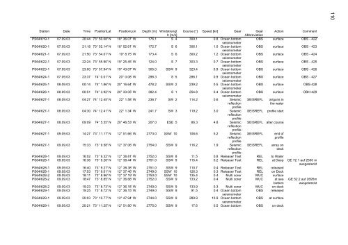
Station Date Time PositionLat PositionLon Depth [m] Windstrengt Course [°] Speed [kn] Gear Gear Action Comment<br />
h [m/s]<br />
Abbreviation<br />
PS64/619-1 07.09.03 20:44 73° 50.08' N 18° 36.07' W 176.1 S 4 309.1 0.8 Ocean bottom<br />
seismometer<br />
OBS surface OBS - 422<br />
PS64/620-1 07.09.03 21:18 73° 52.14' N 18° 52.61' W 172.7 S 6 306.1 1.0 Ocean bottom<br />
seismometer<br />
OBS surface OBS - 423<br />
PS64/621-1 07.09.03 21:50 73° 54.01' N 19° 8.75' W 173.4 S 6 300.2 1.2 Ocean bottom<br />
seismometer<br />
OBS surface OBS - 424<br />
PS64/622-1 07.09.03 22:24 73° 55.90' N 19° 25.45' W 124.0 S 7 303.3 0.7 Ocean bottom<br />
seismometer<br />
OBS surface OBS - 425<br />
PS64/623-1 07.09.03 23:00 73° 57.94' N 19° 43.07' W 305.0 SSW 9 323.4 0.9 Ocean bottom<br />
seismometer<br />
OBS surface OBS - 426<br />
PS64/624-1 07.09.03 23:37 74° 0.01' N 20° 0.08' W 298.3 S 5 286.1 0.9 Ocean bottom<br />
seismometer<br />
OBS surface OBS - 427<br />
PS64/625-1 08.09.03 00:14 74° 1.86' N 20° 16.64' W 478.2 SSW 2 239.2 0.5 Ocean bottom<br />
seismometer<br />
OBS surface OBS-428<br />
PS64/626-1 08.09.03 00:51 74° 3.92' N 20° 33.05' W 382.4 S 1 254.8 0.4 Ocean bottom<br />
seismometer<br />
OBS surface OBH-429<br />
PS64/627-1 08.09.03 04:27 74° 12.45' N 22° 1.58' W 236.7 SW 2 114.2 0.6 Seismic SEISREFL airguns in<br />
reflection<br />
pr<strong>of</strong>ile<br />
<strong>the</strong> water<br />
PS64/627-1 08.09.03 04:30 74° 12.41' N 22° 1.34' W 241.7 SW 3 119.2 3.0 Seismic<br />
reflection<br />
pr<strong>of</strong>ile<br />
SEISREFL pr<strong>of</strong>ile start<br />
PS64/627-1 08.09.03 09:09 74° 5.55' N 20° 46.53' W 207.0 ESE 5 86.3 4.8 Seismic<br />
reflection<br />
pr<strong>of</strong>ile<br />
SEISREFL alter course<br />
PS64/627-1 09.09.03 14:27 73° 11.17' N 12° 51.66' W 2773.0 SSW 10 108.6 5.2 Seismic SEISREFL end <strong>of</strong><br />
reflection<br />
pr<strong>of</strong>ile<br />
pr<strong>of</strong>ile<br />
PS64/627-1 09.09.03 15:33 73° 9.58' N 12° 37.06' W 2754.0 SSW 9 116.2 1.9 Seismic SEISREFL array on<br />
reflection<br />
pr<strong>of</strong>ile<br />
deck<br />
PS64/628-1 09.09.03 16:02 73° 9.32' N 12° 38.81' W 2752.0 SSW 8 11.5 0.8 Releaser Test REL to Water<br />
PS64/628-1 09.09.03 16:36 73° 9.28' N 12° 38.44' W 2751.0 SSW 9 115.4 0.2 Releaser Test REL at Deep GE 72.1 auf 2500 m<br />
ausgesteckt<br />
PS64/628-1 09.09.03 16:40 73° 9.27' N 12° 38.38' W 2751.0 SSW 9 110.7 0.4 Releaser Test REL released<br />
PS64/628-1 09.09.03 17:53 73° 9.01' N 12° 37.46' W 2749.0 SSW 10 126.3 0.3 Releaser Test REL on Deck<br />
PS64/628-2 09.09.03 18:11 73° 8.96' N 12° 37.19' W 2750.0 SSW 10 135.4 0.4 Multi corer MUC surface<br />
PS64/628-2 09.09.03 18:47 73° 8.85' N 12° 36.68' W 2752.0 SSW 9 133.2 0.4 Multi corer MUC at sea GE 52.2 auf 2695m<br />
bottom ausgesteckt<br />
PS64/628-2 09.09.03 19:23 73° 8.73' N 12° 36.18' W 2749.0 SSW 9 133.9 0.3 Multi corer MUC on deck<br />
PS64/629-1 09.09.03 19:25 73° 8.72' N 12° 36.15' W 2749.0 SSW 9 91.5 0.4 Ocean bottom<br />
seismometer<br />
OBS released<br />
PS64/629-1 09.09.03 20:03 73° 10.77' N 12° 47.94' W 2744.0 SSW 9 289.9 10.9 Ocean bottom<br />
seismometer<br />
OBS at surface<br />
PS64/629-1 09.09.03 20:21 73° 11.25' N 12° 51.80' W 2775.0 SSW 9 17.6 0.5 Ocean bottom OBS on deck<br />
110


