

the Expedition ARKTIS-XIX/4 of the research vessel POLARSTERN ...
the Expedition ARKTIS-XIX/4 of the research vessel POLARSTERN ...
the Expedition ARKTIS-XIX/4 of the research vessel POLARSTERN ...

You also want an ePaper? Increase the reach of your titles
YUMPU automatically turns print PDFs into web optimized ePapers that Google loves.
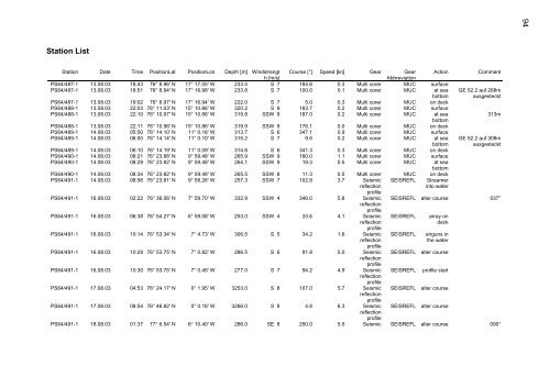
Station List<br />
Station Date Time PositionLat PositionLon Depth [m] Windstrengt Course [°] Speed [kn] Gear Gear Action Comment<br />
h [m/s]<br />
Abbreviation<br />
PS64/487-1 13.08.03 18:43 76° 8.96' N 17° 17.05' W 233.4 S 7 184.6 0.3 Multi corer MUC surface<br />
PS64/487-1 13.08.03 18:51 76° 8.94' N 17° 16.98' W 233.8 S 7 100.0 0.1 Multi corer MUC at sea GE 52.2 auf 268m<br />
bottom ausgesteckt<br />
PS64/487-1 13.08.03 19:02 76° 8.97' N 17° 16.94' W 222.0 S 7 5.0 0.3 Multi corer MUC on deck<br />
PS64/488-1 13.08.03 22:03 76° 11.03' N 15° 10.86' W 320.2 S 9 183.7 0.2 Multi corer MUC surface<br />
PS64/488-1 13.08.03 22:10 76° 10.97' N 15° 10.86' W 319.8 SSW 9 187.0 0.2 Multi corer MUC at sea<br />
bottom<br />
313m<br />
PS64/488-1 13.08.03 22:11 76° 10.96' N 15° 10.86' W 319.9 SSW 9 176.1 0.0 Multi corer MUC on deck<br />
PS64/489-1 14.08.03 05:50 76° 14.10' N 11° 0.18' W 313.7 S 6 347.1 0.9 Multi corer MUC surface<br />
PS64/489-1 14.08.03 06:00 76° 14.14' N 11° 0.10' W 315.2 S 7 9.6 0.2 Multi corer MUC at sea GE 52.2 auf 308m<br />
bottom ausgesteckt<br />
PS64/489-1 14.08.03 06:10 76° 14.19' N 11° 0.09' W 314.6 S 6 341.3 0.3 Multi corer MUC on deck<br />
PS64/490-1 14.08.03 08:21 76° 23.88' N 9° 59.48' W 265.9 SSW 9 180.0 1.1 Multi corer MUC surface<br />
PS64/490-1 14.08.03 08:29 76° 23.82' N 9° 59.48' W 264.1 SSW 9 19.3 0.5 Multi corer MUC at sea<br />
bottom<br />
PS64/490-1 14.08.03 08:34 76° 23.82' N 9° 59.48' W 265.5 SSW 8 11.3 0.5 Multi corer MUC on deck<br />
PS64/491-1 14.08.03 08:56 76° 23.81' N 9° 58.26' W 257.3 SSW 7 102.8 3.7 Seismic SEISREFL Streamer<br />
reflection<br />
pr<strong>of</strong>ile<br />
into water<br />
PS64/491-1 16.08.03 02:22 76° 36.06' N 7° 59.70' W 332.9 SSW 4 346.0 5.8 Seismic<br />
reflection<br />
pr<strong>of</strong>ile<br />
SEISREFL alter course 037°<br />
PS64/491-1 16.08.03 06:38 76° 54.27' N 6° 59.08' W 253.0 SSW 4 33.6 4.1 Seismic SEISREFL array on<br />
reflection<br />
pr<strong>of</strong>ile<br />
deck<br />
PS64/491-1 16.08.03 10:14 76° 53.34' N 7° 4.73' W 306.5 S 5 34.2 1.6 Seismic SEISREFL airguns in<br />
reflection<br />
pr<strong>of</strong>ile<br />
<strong>the</strong> water<br />
PS64/491-1 16.08.03 10:29 76° 53.75' N 7° 0.82' W 286.5 S 6 91.8 5.0 Seismic<br />
reflection<br />
pr<strong>of</strong>ile<br />
SEISREFL alter course<br />
PS64/491-1 16.08.03 10:30 76° 53.75' N 7° 0.45' W 277.0 S 7 94.2 4.9 Seismic<br />
reflection<br />
pr<strong>of</strong>ile<br />
SEISREFL pr<strong>of</strong>ile start<br />
PS64/491-1 17.08.03 04:53 76° 24.17' N 0° 1.95' W 3253.0 S 8 107.0 5.7 Seismic<br />
reflection<br />
pr<strong>of</strong>ile<br />
SEISREFL alter course<br />
PS64/491-1 17.08.03 08:54 76° 46.82' N 0° 0.18' W 3266.0 S 8 4.8 6.3 Seismic<br />
reflection<br />
pr<strong>of</strong>ile<br />
SEISREFL alter course<br />
PS64/491-1 18.08.03 01:37 77° 6.54' N 6° 10.40' W 286.0 SE 8 250.0 5.5 Seismic SEISREFL alter course 090°<br />
94


