

the Expedition ARKTIS-XIX/4 of the research vessel POLARSTERN ...
the Expedition ARKTIS-XIX/4 of the research vessel POLARSTERN ...
the Expedition ARKTIS-XIX/4 of the research vessel POLARSTERN ...

You also want an ePaper? Increase the reach of your titles
YUMPU automatically turns print PDFs into web optimized ePapers that Google loves.
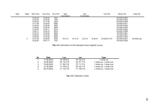
Date Flight Start Time End Time No <strong>of</strong> Fid Start<br />
End<br />
Text File Binary File Data File<br />
Coordinates<br />
Coordinates<br />
12:30:18 12:30:22 1491 S3100512.B30<br />
12:30:22 12:30:25 1493 S3100512.B3A<br />
12:30:25 13:11:08 3935 S3100512.B3R<br />
13:11:08 13:39:54 5660 S3100513.B11<br />
13:39:54 13:39:59 5665 S3100513.B39<br />
13:39:59 13:40:05 5669 S3100513.B40<br />
13:40:05 13:40:11 5674 S3100513.B4A<br />
13:40:11 13:40:16 5678 S3100513.B4R<br />
13:40:16 13:40:22 5683 S3100513.B4c<br />
13:40:22 13:40:29 5889 S3100513.B4t<br />
13:40:29 14:19:30 8029 S3100513.B4U<br />
3 14:37:29 15:28:05 3036 72.41 N 16.13 W 72.27 N 16.38 W S3100514.T37 S3100514.B37 0310053.raw<br />
15:28:05 16:47:11 7781 S3100515.B28<br />
Tab. 2-4: Information on <strong>the</strong> helicopter borne magnetic survey<br />
Nr. Date Lon Lat Type<br />
1 11.08.2003 18° 49.8' E 70° 33.2' N 1 circle cw<br />
2 23.08.2003 18° 10.5' W 76° 07.1' N 1 circle cw, 1 circle ccw<br />
3 19.09.2003 11° 59.0' W 73° 11.7' N 1 circle cw, 1 circle ccw<br />
4 21.09.2003 11° 59.0' E 78° 02.7' N 1 circle cw, 1 circle ccw<br />
5 06.10.2003 17° 12.5' W 71° 35.0' N 1 circle cw, 1 circle ccw<br />
Tab. 2-5: Calibration circles<br />
29


