the Expedition ARKTIS-XIX/4 of the research vessel POLARSTERN ...
the Expedition ARKTIS-XIX/4 of the research vessel POLARSTERN ...
the Expedition ARKTIS-XIX/4 of the research vessel POLARSTERN ...
Create successful ePaper yourself
Turn your PDF publications into a flip-book with our unique Google optimized e-Paper software.
The second coring system used was a piston corer (UWITEC Corp., Austria). This<br />
system is handled via a tripod on <strong>the</strong> floating platform and allows obtaining deeper<br />
sediments up to c. 20 m depth. The piston corer consists <strong>of</strong> a 3.3 m long metal tube,<br />
which is loaded with a 3 m long PVC liner <strong>of</strong> 6 cm diameter. Thus, <strong>the</strong> maximum<br />
penetration <strong>of</strong> <strong>the</strong> corer into <strong>the</strong> sediment is 3 m at each coring process. Because <strong>the</strong><br />
release <strong>of</strong> <strong>the</strong> piston in <strong>the</strong> water or sediment column can be controlled, longer<br />
sediment records can be obtained by overlapping <strong>of</strong> several 3 m segments. The<br />
penetration <strong>of</strong> <strong>the</strong> corer tube will be hampered, for example, by massive sand layers,<br />
too coarse, or very consolidated sediments. An over consolidated diamicton, which<br />
<strong>of</strong>ten forms <strong>the</strong> basis <strong>of</strong> lacustrine sediments in polar regions, will stop <strong>the</strong> coring<br />
process in general. The maximum core length obtained during <strong>the</strong> field period in<br />
2003 was more than 10 m.<br />
The third coring system used during <strong>the</strong> field season was a Russian peat corer,<br />
which was employed on <strong>the</strong> shallower lakes <strong>of</strong> up to 10 m water depth. This corer<br />
enables to recover sediment sequences <strong>of</strong> 1 m length at each coring process. Longer<br />
sequences are obtained by a new coring process in <strong>the</strong> deeper sediments. The<br />
maximum penetration depends on <strong>the</strong> water depth and <strong>the</strong> consistency <strong>of</strong> <strong>the</strong><br />
sediments. During <strong>the</strong> field period in 2003 on Store Koldewey, <strong>the</strong> maximum core<br />
length obtained with <strong>the</strong> Russian peat corer was 2.8 m. Additionally to <strong>the</strong> above<br />
described coring systems, two short sediment cores were taken by hand from <strong>the</strong><br />
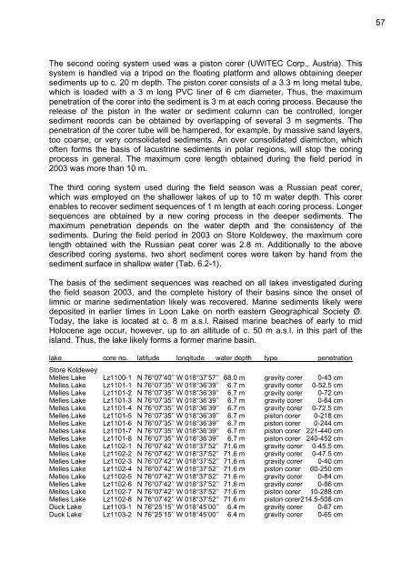
sediment surface in shallow water (Tab. 6.2-1).<br />
The basis <strong>of</strong> <strong>the</strong> sediment sequences was reached on all lakes investigated during<br />
<strong>the</strong> field season 2003, and <strong>the</strong> complete history <strong>of</strong> <strong>the</strong>ir basins since <strong>the</strong> onset <strong>of</strong><br />
limnic or marine sedimentation likely was recovered. Marine sediments likely were<br />
deposited in earlier times in Loon Lake on north eastern Geographical Society Ø.<br />
Today, <strong>the</strong> lake is located at c. 8 m a.s.l. Raised marine beaches <strong>of</strong> early to mid<br />
Holocene age occur, however, up to an altitude <strong>of</strong> c. 50 m a.s.l. in this part <strong>of</strong> <strong>the</strong><br />
island. Thus, <strong>the</strong> lake likely forms a former marine basin.<br />
lake core no. latitude longitude water depth type penetration<br />
Store Koldewey<br />
Melles Lake Lz1100-1 N 76°07’40’’ W 018°37’57’’ 68.0 m gravity corer 0-43 cm<br />
Melles Lake Lz1101-1 N 76°07’35’’ W 018°36’39’’ 6.7 m gravity corer 0-52.5 cm<br />
Melles Lake Lz1101-2 N 76°07’35’’ W 018°36’39’’ 6.7 m gravity corer 0-72 cm<br />
Melles Lake Lz1101-3 N 76°07’35’’ W 018°36’39’’ 6.7 m gravity corer 0-64 cm<br />
Melles Lake Lz1101-4 N 76°07’35’’ W 018°36’39’’ 6.7 m gravity corer 0-72.5 cm<br />
Melles Lake Lz1101-5 N 76°07’35’’ W 018°36’39’’ 6.7 m piston corer 0-218 cm<br />
Melles Lake Lz1101-6 N 76°07’35’’ W 018°36’39’’ 6.7 m piston corer 0-244 cm<br />
Melles Lake Lz1101-7 N 76°07’35’’ W 018°36’39’’ 6.7 m piston corer 221-440 cm<br />
Melles Lake Lz1101-8 N 76°07’35’’ W 018°36’39’’ 6.7 m piston corer 240-452 cm<br />
Melles Lake Lz1102-1 N 76°07’42’’ W 018°37’52’’ 71.6 m gravity corer 0-45.5 cm<br />
Melles Lake Lz1102-2 N 76°07’42’’ W 018°37’52’’ 71.6 m gravity corer 0-47.5 cm<br />
Melles Lake Lz1102-3 N 76°07’42’’ W 018°37’52’’ 71.6 m gravity corer 0-40 cm<br />
Melles Lake Lz1102-4 N 76°07’42’’ W 018°37’52’’ 71.6 m piston corer 60-250 cm<br />
Melles Lake Lz1102-5 N 76°07’42’’ W 018°37’52’’ 71.6 m gravity corer 0-84 cm<br />
Melles Lake Lz1102-6 N 76°07’42’’ W 018°37’52’’ 71.6 m gravity corer 0-86 cm<br />
Melles Lake Lz1102-7 N 76°07’42’’ W 018°37’52’’ 71.6 m piston corer 10-288 cm<br />
Melles Lake Lz1102-8 N 76°07’42’’ W 018°37’52’’ 71.6 m piston corer214.5-508 cm<br />
Duck Lake Lz1103-1 N 76°25’15’’ W 018°45’00’’ 6.4 m gravity corer 0-67 cm<br />
Duck Lake Lz1103-2 N 76°25’15’’ W 018°45’00’’ 6.4 m gravity corer 0-65 cm<br />
57


