

the Expedition ARKTIS-XIX/4 of the research vessel POLARSTERN ...
the Expedition ARKTIS-XIX/4 of the research vessel POLARSTERN ...
the Expedition ARKTIS-XIX/4 of the research vessel POLARSTERN ...

You also want an ePaper? Increase the reach of your titles
YUMPU automatically turns print PDFs into web optimized ePapers that Google loves.
30<br />
Preliminary results<br />
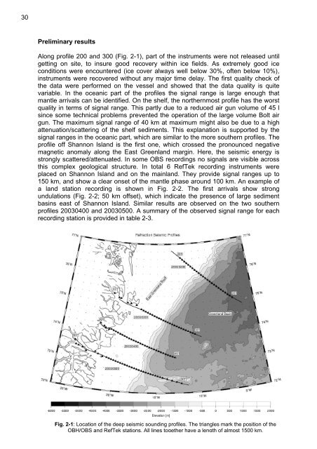
Along pr<strong>of</strong>ile 200 and 300 (Fig. 2-1), part <strong>of</strong> <strong>the</strong> instruments were not released until<br />
getting on site, to insure good recovery within ice fields. As extremely good ice<br />
conditions were encountered (ice cover always well below 30%, <strong>of</strong>ten below 10%),<br />
instruments were recovered without any major time delay. The first quality check <strong>of</strong><br />
<strong>the</strong> data were performed on <strong>the</strong> <strong>vessel</strong> and showed that <strong>the</strong> data quality is quite<br />
variable. In <strong>the</strong> oceanic part <strong>of</strong> <strong>the</strong> pr<strong>of</strong>iles <strong>the</strong> signal range is large enough that<br />
mantle arrivals can be identified. On <strong>the</strong> shelf, <strong>the</strong> nor<strong>the</strong>rnmost pr<strong>of</strong>ile has <strong>the</strong> worst<br />
quality in terms <strong>of</strong> signal range. This partly due to a reduced air gun volume <strong>of</strong> 45 l<br />
since some technical problems prevented <strong>the</strong> operation <strong>of</strong> <strong>the</strong> large volume Bolt air<br />
gun. The maximum signal range <strong>of</strong> 40 km at maximum might also be due to a high<br />
attenuation/scattering <strong>of</strong> <strong>the</strong> shelf sediments. This explanation is supported by <strong>the</strong><br />
signal ranges in <strong>the</strong> oceanic part, which are similar to <strong>the</strong> more sou<strong>the</strong>rn pr<strong>of</strong>iles. The<br />
pr<strong>of</strong>ile <strong>of</strong>f Shannon Island is <strong>the</strong> first one, which crossed <strong>the</strong> pronounced negative<br />
magnetic anomaly along <strong>the</strong> East Greenland margin. Here, <strong>the</strong> seismic energy is<br />
strongly scattered/attenuated. In some OBS recordings no signals are visible across<br />
this complex geological structure. In total 6 RefTek recording instruments were<br />
placed on Shannon Island and on <strong>the</strong> mainland. They provide signal ranges up to<br />
150 km, and show a clear onset <strong>of</strong> <strong>the</strong> mantle phase around 100 km. An example <strong>of</strong><br />
a land station recording is shown in Fig. 2-2. The first arrivals show strong<br />
undulations (Fig. 2-2; 50 km <strong>of</strong>fset), which indicate <strong>the</strong> presence <strong>of</strong> large sediment<br />
basins east <strong>of</strong> Shannon Island. Similar results are observed on <strong>the</strong> two sou<strong>the</strong>rn<br />
pr<strong>of</strong>iles 20030400 and 20030500. A summary <strong>of</strong> <strong>the</strong> observed signal range for each<br />
recording station is provided in table 2-3.<br />
Fig. 2-1: Location <strong>of</strong> <strong>the</strong> deep seismic sounding pr<strong>of</strong>iles. The triangles mark <strong>the</strong> position <strong>of</strong> <strong>the</strong><br />
OBH/OBS and RefTek stations. All lines toge<strong>the</strong>r have a length <strong>of</strong> almost 1500 km.


