

the Expedition ARKTIS-XIX/4 of the research vessel POLARSTERN ...
the Expedition ARKTIS-XIX/4 of the research vessel POLARSTERN ...
the Expedition ARKTIS-XIX/4 of the research vessel POLARSTERN ...

Create successful ePaper yourself
Turn your PDF publications into a flip-book with our unique Google optimized e-Paper software.
32<br />
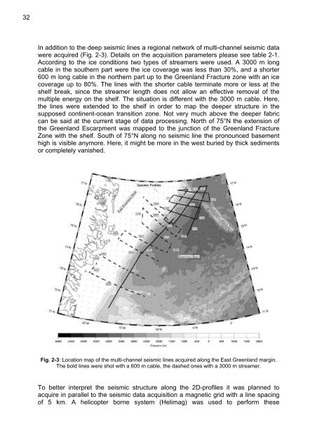
In addition to <strong>the</strong> deep seismic lines a regional network <strong>of</strong> multi-channel seismic data<br />
were acquired (Fig. 2-3). Details on <strong>the</strong> acquisition parameters please see table 2-1.<br />
According to <strong>the</strong> ice conditions two types <strong>of</strong> streamers were used. A 3000 m long<br />
cable in <strong>the</strong> sou<strong>the</strong>rn part were <strong>the</strong> ice coverage was less than 30%, and a shorter<br />
600 m long cable in <strong>the</strong> nor<strong>the</strong>rn part up to <strong>the</strong> Greenland Fracture zone with an ice<br />
coverage up to 80%. The lines with <strong>the</strong> shorter cable terminate more or less at <strong>the</strong><br />
shelf break, since <strong>the</strong> streamer length does not allow an effective removal <strong>of</strong> <strong>the</strong><br />
multiple energy on <strong>the</strong> shelf. The situation is different with <strong>the</strong> 3000 m cable. Here,<br />
<strong>the</strong> lines were extended to <strong>the</strong> shelf in order to map <strong>the</strong> deeper structure in <strong>the</strong><br />
supposed continent-ocean transition zone. Not very much above <strong>the</strong> deeper fabric<br />
can be said at <strong>the</strong> current stage <strong>of</strong> data processing. North <strong>of</strong> 75°N <strong>the</strong> extension <strong>of</strong><br />
<strong>the</strong> Greenland Escarpment was mapped to <strong>the</strong> junction <strong>of</strong> <strong>the</strong> Greenland Fracture<br />
Zone with <strong>the</strong> shelf. South <strong>of</strong> 75°N along no seismic line <strong>the</strong> pronounced basement<br />
high is visible anymore. Here, it might be more in <strong>the</strong> west buried by thick sediments<br />
or completely vanished.<br />
Fig. 2-3: Location map <strong>of</strong> <strong>the</strong> multi-channel seismic lines acquired along <strong>the</strong> East Greenland margin.<br />
The bold lines were shot with a 600 m cable, <strong>the</strong> dashed ones with a 3000 m streamer.<br />
To better interpret <strong>the</strong> seismic structure along <strong>the</strong> 2D-pr<strong>of</strong>iles it was planned to<br />
acquire in parallel to <strong>the</strong> seismic data acquisition a magnetic grid with a line spacing<br />
<strong>of</strong> 5 km. A helicopter borne system (Helimag) was used to perform <strong>the</strong>se


