

the Expedition ARKTIS-XIX/4 of the research vessel POLARSTERN ...
the Expedition ARKTIS-XIX/4 of the research vessel POLARSTERN ...
the Expedition ARKTIS-XIX/4 of the research vessel POLARSTERN ...

You also want an ePaper? Increase the reach of your titles
YUMPU automatically turns print PDFs into web optimized ePapers that Google loves.
54<br />
In <strong>the</strong> shallow ponds <strong>the</strong> hydrological measurements were carried out at one surface<br />
sample from <strong>the</strong> central part. The locations for <strong>the</strong> hydrological measurements in <strong>the</strong><br />
deeper lakes were determined with a hand echo sounder along several pr<strong>of</strong>iles<br />
across <strong>the</strong> lakes, which revealed <strong>the</strong> maximum water depths <strong>of</strong> <strong>the</strong> lake basins. At<br />
locations, where <strong>the</strong> maximum water depth was measured, samples were taken from<br />
different depths using a water sampler (UWITEC Corp., Austria). The water sampler<br />
is released by a short uplift in a certain depth and contains 5 l <strong>of</strong> water. Once at <strong>the</strong><br />
surface about 1 l was immediately used to measure temperature, O2-saturation and<br />
content, conductivity, and pH value. On selected horizons water samples were taken<br />
in order to determine <strong>the</strong> anion and cation contents and <strong>the</strong> contents <strong>of</strong> methane and<br />
dissolved organic carbon (DOC) throughout <strong>the</strong> water column. For <strong>the</strong> analyses <strong>of</strong><br />
<strong>the</strong> DOC, anion, and cation contents three samples <strong>of</strong> 30 ml were filled into Nalgene<br />
bottles, <strong>the</strong> latter ones after filtering <strong>the</strong> water through a 0.45 µm filter. The samples<br />
for cation analyses were additionally fixed by adding 200 ml <strong>of</strong> NaOH. For <strong>the</strong><br />
measurements <strong>of</strong> <strong>the</strong> methane content, water was filled into glass bottles, which<br />
contained NaCl in order to release <strong>the</strong> gas from <strong>the</strong> water. Finally, <strong>the</strong> visibility <strong>of</strong> <strong>the</strong><br />
lakes was determined using a Secchi disc.<br />
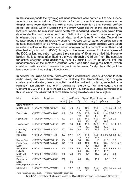
In general, <strong>the</strong> lakes on Store Koldewey and Geographical Society Ø belong to high<br />
arctic lakes, and are characterized by relatively low temperatures, high oxygen<br />
content and saturation, low conductivity and low nutrient contents, reflected in a<br />
relatively high visibility (Tab. 6.1-1). During <strong>the</strong> field period from mid August to mid<br />
September 2003 <strong>the</strong> lakes were not covered by ice, although a lateral formation <strong>of</strong> a<br />
thin ice cover was observed at some lakes during cloudless and calm nights.<br />
lake latitude longitude alt.<br />
1<br />
mwd temp. O2-sat. O2-cont. conduct. pH vis. 2<br />
(m asl) (m) (°C) (%) (mg/l) (µS/cm) (m)<br />
Store Koldewey<br />
Melles Lake N76°07’40’’ W018°37’57’’ 166 72.0 4.0- 102- 11.8- 37.0- 7.9-8.1 5.4<br />
6.8 112 14.0 38.0<br />
Duck Lake N76°25’15’’ W018°45’00’’ 118 6.4 6.7- 126- 14.9- 11.0- 8.6-9.0 5.8<br />
7.2 130 15.5 11.9<br />
Hjort Lake N76°25’59’’ W018°45’41’’ 122 6.1 5.3- 115- 14.9- 15.7- 9.1-9.3<br />
5.4 128 15.4 16.3<br />
Goose Lake N76°26’36’’ W018°48’14’’ 115 7.4 4.4- 118- 14.5- 11.0- 8.9-9.1 4.8<br />
4.9 122 15.3 12.2<br />
Lemming<br />
Lake<br />
N76°25’42’’ W018°47’44’’ 121 2.0 5.8 125 15.3 23.7 8.3<br />
Fox Lake N76°15’06’’ W018°41’32’’ 302 57.7 4.7- 111- 13.6- 8.7-9.3 7.5-8.4 8.1<br />
4.8 116 14.5<br />
Raven Pond N76°16’34’’ W018°36’18’’ 104 0.4 2.4 126 16 21.0 8.2<br />
Polar Bear N76°14’10’’ W018°43’48’’ 175 15.9 3.3 121- 15.2- 30.8- 8.2-8.5 7.3<br />
Lake 1<br />
125 15.7 35.1<br />
Polar Bear N76°14’01’’ W018°46’12’’ 129 12.3 3.4- 123- 15.5- 41.3– 8.3-8.4 3.3<br />
Lake 3<br />
3.5 126 16.0 41.5<br />
Musk Ox<br />
Pond<br />
N76°13’57’’ W018°35’55’’ 115 0.2 2.6 120 15.9 26.9 8.4<br />
Panorama N76°14’51’’ W018°45’34’’ 602 c. 0.8 120 15.9 8.0 8.5<br />
Lake<br />
5.0<br />
Geographical Society Ø<br />
Loon Lake N72°53’16’’ W022°08’22’’ 8 11.7 7.4- 120- 14.2- 23.2- 7.6-8.0 3.0<br />
7.8 122 14.6 23.4<br />
1 mwd = maximum water depth 2 visibility measured by Secchi disc<br />
Tab. 6.1-1: Hydrology <strong>of</strong> lakes and ponds on Store Koldewey and Geographical Society Ø


