

the Expedition ARKTIS-XIX/4 of the research vessel POLARSTERN ...
the Expedition ARKTIS-XIX/4 of the research vessel POLARSTERN ...
the Expedition ARKTIS-XIX/4 of the research vessel POLARSTERN ...

You also want an ePaper? Increase the reach of your titles
YUMPU automatically turns print PDFs into web optimized ePapers that Google loves.
42<br />
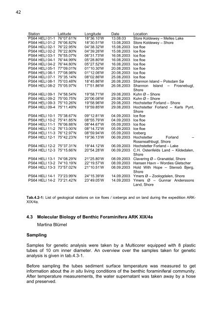
Station Latitude Longitude Date Location<br />
PS64 HELI 01-1 76°07.61’N 18°36.10’W 13.08.03 Store Koldewey – Melles Lake<br />
PS64 HELI 01-2 76°06.82'N 18°30.51'W 13.08.2003 Store Koldewey – Shore<br />
PS64 HELI 02-1 76°22.95'N 04°38.32'W 15.08.2003 Ice floe<br />
PS64 HELI 02-2 76°22.80'N 04°39.26'W 15.08.2003 Ice floe<br />
PS64 HELI 03-1 76°55.07'N 06°31.73'W 16.08.2003 Ice floe<br />
PS64 HELI 04-1 76°44.99'N 05°28.80'W 16.08.2003 Ice floe<br />
PS64 HELI 04-2 76°44.80'N 05°27.52'W 16.08.2003 Ice floe<br />
PS64 HELI 05-1 77°09.01'N 01°10.30'W 20.08.2003 Ice floe<br />
PS64 HELI 06-1 77°08.98'N 01°12.06'W 20.08.2003 Ice floe<br />
PS64 HELI 07-1 75°35.14'N 08°02.86'W 25.08.2003 Ice floe<br />
PS64 HELI 08-1 75°03.48'N 18°45.86'W 26.08.2003 Shannon Island – Potsdam Sø<br />
PS64 HELI 08-2 75°05.97'N 17°51.86'W 26.08.2003 Shannon Island – Frosnebugt,<br />
Shore<br />
PS64 HELI 09-1 74°58.54'N 19°58.71'W 29.08.2003 Kuhn Ø – Shore<br />
PS64 HELI 09-2 75°00.75'N 20°06.08'W 29.08.2003 Kuhn Ø – Shore<br />
PS64 HELI 09-3 75°10.26'N 19°58.96'W 29.08.2003 Hochstetter Forland – Shore<br />
PS64 HELI 09-4 75°11.49'N 19°59.85'W 29.08.2003 Hochstetter Forland – Karls Pynt,<br />
Shore<br />
PS64 HELI 10-1 75°38.67’N 09°12.81’W 04.09.2003 Ice floe<br />
PS64 HELI 10-2 75°41.85’N 08°55.79’W 04.09.2003 Ice floe<br />
PS64 HELI 11-1 76°06.88’N 08°44.67’W 05.09.2003 Ice floe<br />
PS64 HELI 11-2 76°13.00’N 08°14.72’W 05.09.2003 Ice floe<br />
PS64 HELI 11-3 76°12.97’N 08°59.94’W 05.09.2003 Iceberg<br />
PS64 HELI 12-1 75°42.23’N 19°36.13’W 06.09.2003 Hochstetter Forland –<br />
Roseneathbugt, Shore<br />
PS64 HELI 12-2 75°37.31’N 19°44.12’W 06.09.2003 Hochstetter Forland – Lake<br />
PS64 HELI 12-3 75°15.66’N 20°54.28’W 06.09.2003 C.H. Ostenfelds Land – Kildedalen,<br />
Shore<br />
PS64 HELI 13-1 74°08.29’N 21°25.80’W 08.09.2003 Clavering Ø – Granatdal, Shore<br />
PS64 HELI 13-2 74°10.19’N 22°19.57’W 08.09.2003 Hansen Havn – Wordies Gletscher<br />
PS64 HELI 13-3 73°57.02’N 21°10.51’W 08.09.2003 Hold With Hope – Stensiö Bjerg,<br />
Shore<br />
PS64 HELI 14-1 73°23.99’N 24°15.39’W 14.09.2003 Ymers Ø – Zoologdalen, Shore<br />
PS64 HELI 14-2 73°21.42’N 23°49.05’W 14.09.2003 Ymers Ø – Gunnar Anderssons<br />
Land, Shore<br />
Tab.4.2-1: List <strong>of</strong> geological stations on ice floes / icebergs and on land during <strong>the</strong> expedition ARK-<br />
<strong>XIX</strong>/4a.<br />
4.3 Molecular Biology <strong>of</strong> Benthic Foraminifera ARK <strong>XIX</strong>/4a<br />
Martina Blümel<br />
Sampling<br />
Samples for genetic analysis were taken by a Multicorer equipped with 8 plastic<br />
tubes <strong>of</strong> 10 cm inner diameter. An overview over <strong>the</strong> samples taken for genetic<br />
analysis is given in tab.4.3-1.<br />
Before sampling <strong>the</strong> tubes sediment surface temperature was measured to get<br />
information about <strong>the</strong> in situ living conditions <strong>of</strong> <strong>the</strong> benthic foraminiferal community.<br />
After temperature measurements, <strong>the</strong> water supernatant was taken away by a hose<br />
and preserved.


