Serengeti General Management Plan
Serengeti General Management Plan
Serengeti General Management Plan
- TAGS
- serengeti
- www.zgf.de

Create successful ePaper yourself
Turn your PDF publications into a flip-book with our unique Google optimized e-Paper software.
<strong>Serengeti</strong> National Park <strong>General</strong> <strong>Management</strong> <strong>Plan</strong><br />
The previous <strong>Serengeti</strong> <strong>Management</strong> Zone <strong>Plan</strong> (1996) designated eight zones; however,<br />
these subsequently proved impractical at the Park management level. As a consequence,<br />
this GMP has simplified the zoning scheme to the following three zones:<br />
20<br />
1. High Use Zone<br />
2. Low Use Zone<br />
3. Wilderness Zone<br />
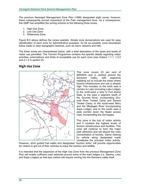
Figure B.5 above defines the zones spatially. Simple zone demarcations are used for easy<br />
identification of each zone for administrative purposes. As far as possible, zone boundaries<br />
follow roads or clear topographic features, such as rivers, streams and hills.<br />
The three zones are characterised below, with a brief description of the types and levels of<br />
visitor use permitted. The Tourism Programme contains the specific details regarding visitor<br />
activities, prescriptions and limits of acceptable use for each zone (see Actions 1.1.1, 1.2.2<br />
and 2.1.2 in section D).<br />
High Use Zone<br />
This zone covers 23 per cent of<br />
SENAPA and is centred around the<br />
Seronera Valley, with segments<br />
radiating out to include the areas where<br />
tourism infrastructure and use is already<br />
high. This includes: to the north east a<br />
corridor to Lobo (including Lobo Lodge);<br />
to the north-west a strip to Fort Ikoma<br />
Gate; to the west a segment south of<br />
the Grumeti River, incorporating Grumeti<br />
River Tented Camp and Serena<br />
Tented Camp; to the south-west Moru<br />
and the Mbalageti River (incorporating<br />
Sopa Lodge); and to the south east a<br />
wide corridor down the Naabi access<br />
road, incorporating the Gol kopjes.<br />
This zone is the hub of visitor activity<br />
and it contains the highest levels of<br />
tourism infrastructure and facilities. This<br />
zone will continue to form the major<br />
park attraction and will absorb the main<br />
concentration of tourists. Game viewing<br />
by vehicle along designated roads<br />
constitutes the principal visitor activity.<br />
However, short guided trail walks and designated “tourism sinks” will provide opportunities<br />
for visitors to get out of their vehicles to enjoy the scenery and wildlife.<br />
It is intended that the expansion of the High Use Zone from the previous <strong>Management</strong> Zone<br />
<strong>Plan</strong> will enable sufficient road networks around some of the main lodges (i.e. Serena, Lobo<br />
and Sopa Lodges) so that less visitors will require coming into the Seronera valley itself.