AMDT AIP NR 08/2013 - ais asecna
AMDT AIP NR 08/2013 - ais asecna
AMDT AIP NR 08/2013 - ais asecna

Create successful ePaper yourself
Turn your PDF publications into a flip-book with our unique Google optimized e-Paper software.
<strong>AIP</strong> 4 AD 2-1-07<br />
ASECNA CENTRAFRIQUE 25 JUILLET <strong>2013</strong><br />
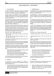
FEFF - AD 2.17 ESPACE AÉRIEN ATS<br />
ATS AIRSPACE<br />
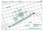
1 Désignation et limites latérales CTR BANGUI : Cercle de 15 NM de BANGUI CTR : Circle of 15 NM<br />
Designation and laterals limits rayon centré sur le VOR/DME ”MPK” radius centred on the VOR/DME ”MPK”<br />
04°22’34,1”N - 018°31’31,3”E<br />
04°22’34,1”N - 018°31’31,3”E<br />
2 Limites verticales / Vertical limits 900 M/SOL 2953 FT/GND<br />
3 Classification de l’espace aérien D<br />
Airspace classification<br />
4 Indicatif d’appel et langues de l’organe BANGUI TOUR - Franç<strong>ais</strong> (Fr) - Angl<strong>ais</strong> (En)<br />
ATS unit call sign/Languages<br />
5 Altitude de transition / Transition altitude 4200 FT<br />
6 Observations / Remarks Aérodrome réservé aux aéronefs munis de radio- AD only authorized for ACFT equipped<br />
communications bilatérales<br />
with bilateral radio communications.<br />
Cheminements d’entrée et de sortie de la CTR. Tracks to enter and to exit the CTR<br />
Tour de piste à l’Ouest de l’aérodrome<br />
RWY circuit in the west from the AD<br />
FEFF - AD 2.18 INSTALLATIONS DE TÉLÉCOMMUNICATION DES SERVICES<br />
DE LA CIRCULATION AÉRIENNE / ATS COMMUNICATION FACILITIES<br />
Désignation Indicatif d’appel Fréquences Heures de Observations<br />
du service Call sign (MHZ - KHZ) fonctionnement Remarks<br />
Service designation Frequency Hours of operation<br />
1 2 3 4 5<br />
TWR BANGUI TOUR 119,7 MHZ H 24 Assure SVC - APP<br />
A/G BANGUI RADIO 6559 - 8903 - 5493 KHZ H 24 P : 1 KW<br />
FEFF - AD 2.19 AIDES DE RADIONAVIGATION ET D’ATTERRISSAGE<br />
RADIO NAVIGATION AND LANDING AIDS<br />
Type d’Aide/ Fréquences Heures de Coordonnées Altitude de<br />
Déclin<strong>ais</strong>on Identification (MHZ-KHZ) fonctionnement antenne émission l’antenne Observations<br />
Type of AID Identification Freguency Hours of Site of antenna Elevation of Remarks<br />
Magnetic variation operation coordinates DME antenna<br />
1 2 3 4 5 6 7<br />
VOR/DME MPK 117,3 Mhz H 24 04°22’34,1”N 362 M P. VOR : 50 W<br />
0° W (2005) CH 120 X 018°31’31,3”E (1187 FT) P. DME : 1 KW<br />
ILS/LLZ BGI 110,3 Mhz H 24 04°24’51,28”N 395 M seuil 17<br />
CAT. II 018°30’55,70”E QDR 346°<br />
0° W (2005)<br />
ALD/DME.P 335 Mhz H 24 04°23’27,23”N 366 M Angle desc.: 3°<br />
0° W (2005) CH 40X 018°31’21,56”E (1201 FT) Glide path slope : 3°<br />
CAT. II jusqu’au seuil<br />
Cat. II until the THR of RWY<br />
NDB BN 265,5 Khz H 24 04°29’25,8”N 18 M P : 50 W<br />
018°29’44,2”E 9112 M Seuil 17 - QDR 346°<br />
NDB PK 305 Khz H24 04°19’27,6”N 18 M P : 100 W<br />
018°32’20,6”E 7285 M Seuil 35 - QDR 166°<br />
(Fonctionnement limité suivre<br />
NOTAM) / Limited operation<br />
follow NOTAM)<br />
SERVICE DE L’INFORMATION<br />
AÉRONAUTIQUE - ASECNA <strong>AMDT</strong> <strong>08</strong>/13