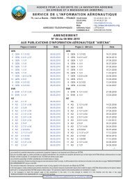
AMDT AIP NR 08/2013 - ais asecna
AMDT AIP NR 08/2013 - ais asecna
AMDT AIP NR 08/2013 - ais asecna

Create successful ePaper yourself
Turn your PDF publications into a flip-book with our unique Google optimized e-Paper software.
<strong>AIP</strong> 12 AD 2-1-07<br />
ASECNA NIGER 25 JUILLET <strong>2013</strong><br />
DRRN - AD 2.17 ESPACE AÉRIEN ATS<br />
ATS AIRSPACE<br />
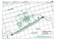
1 Désignation et limites latérales CTR NIAMEY : Cercle de 15 NM de rayon centré NIAMEY CTR : Circle of 15 NM<br />
Designation and laterals limits sur le VOR/DME ”NY” radius centred on VOR/DME ”NY”<br />
13°29’00,0” N - 002°12’23,0” E 13°29’00,0” N - 002°12’23,0” E<br />
2 Limites verticales / Vertical limits 900 M/SOL 2953 FT/GND<br />
3 Classification de l’espace aérien D<br />
Airspace classification<br />
4 Indicatif d’appel et langues de l’organe NIAMEY TOUR - Franç<strong>ais</strong> (Fr) - Angl<strong>ais</strong> (En)<br />
ATS unit call sign/Languages<br />
5 Altitude de transition / Transition altitude 3300 FT<br />
6 Observations / Remarks Aérodrome interdit aux aéronefs non munis de AD prohibited for ACFT not equipped<br />
radiocommunications bilatérales. Plan de vol obli- with bilateral radio communications.<br />
gatoire pour aéronefs s’éloignant à plus de 20 KM Obligatory FPL for ACFT flying away<br />
de l’aérodrome. Tour de piste à vue pour l’Aéro more than 20 KM from the AD. Visual<br />
Club. Cheminements d’entrée et de sortie de la aerodrome traffic circuit for Aero-Club<br />
CTR. Survol de la ville interdit (voir consignes).<br />
Piste parallèle 09 / 27 en latérite.<br />
Arrival and departure routes in CTR.<br />
Flying over the city prohibited (see<br />
instructions). Parallel RWY 09 / 27 in<br />
laterite.<br />
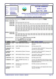
DRRN - AD 2.18 INSTALLATIONS DE TÉLÉCOMMUNICATION DES SERVICES<br />
DE LA CIRCULATION AÉRIENNE / ATS COMMUNICATION FACILITIES<br />
Désignation Indicatif d’appel Fréquences Heures de Observations<br />
du service<br />
Call sign<br />
(MHZ - KHZ)<br />
fonctionnement<br />
Remarks<br />
Service designation Frequency Hours of operation<br />
1 2 3 4 5<br />
TWR NIAMEY TOUR 119,7 MHZ H 24 Assure APP - P : 50 W<br />
118,1 MHZ Fréquence secondaire<br />
Approche - P : 50 W<br />
ACC NIAMEY 131,3 MHZ H 24 P : 50 W<br />
CONTRÔLE<br />
Assure le contrôle régional<br />
NIAMEY CONTRÔLE<br />
126,1 MHZ<br />
Antennes déportées VSAT à<br />
ACC / FIC<br />
Gao, Agadès, Zinder,<br />
NIAMEY 2878 - 3419 - 5493 - 5652 - 6586 KHZ H 24<br />
Tessalit, Tombouctou,<br />
INFORMATION 8894 - 8903 - 13273 - 13294 KHZ<br />
Tahoua, Mopti, Kidal et<br />
Dirkou<br />
P (HF) : 1 KW<br />
P (VHF) : 50 KW<br />
DETRESSE NIAMEY 121,5 MHZ H 24 P : 50 W<br />
DRRN - AD 2.19 AIDES DE RADIONAVIGATION ET D’ATTERRISSAGE<br />
RADIO NAVIGATION AND LANDING AIDS<br />
Type d’Aide/<br />
Heures de Coordonnées Altitude de<br />
Fréquences<br />
Déclin<strong>ais</strong>on Identification<br />
fonctionnement antenne émission l’antenne Observations<br />
(MHZ-KHZ)<br />
Type of AID Identification<br />
Hours of Site of antenna Elevation of Remarks<br />
Freguency<br />
Magnetic variation operation coordinates DME antenna<br />
1 2 3 4 5 6 7<br />
VOR/DME NY 114,1 MHZ H 24 13°29’00,0” N 220 M P. VOR : 50 W<br />
2° W (2010) CH 88 X 002°12’23,0” E (723 FT) P. DME : 1 KW<br />
ILS/LLZ NM 109,9 MHZ H 24 13°28’59,1” N 214 M 459 M seuil 27<br />
CAT. II 002°12’04,9” E (702 FT) QDR <strong>08</strong>9°<br />
ALD/DME.P 333,8 MHZ H 24 13°28’50,25” N 240 M Angle descente : 3°<br />
2° W (2010) CH 36 X 002°10’21,19” E (787 FT) Glide path slope : 3°<br />
CAT. II jusqu’au seuil<br />
CAT. II until the THR of RWY<br />
SERVICE DE L’INFORMATION<br />
AÉRONAUTIQUE - ASECNA <strong>AMDT</strong> <strong>08</strong>/13