Annual Report 2012 - Departement Bau, Umwelt und Geomatik ...
Annual Report 2012 - Departement Bau, Umwelt und Geomatik ...
Annual Report 2012 - Departement Bau, Umwelt und Geomatik ...
- Keine Tags gefunden...

Erfolgreiche ePaper selbst erstellen
Machen Sie aus Ihren PDF Publikationen ein blätterbares Flipbook mit unserer einzigartigen Google optimierten e-Paper Software.
DAS STUDIUM<br />
STUDY PROGRAMMES<br />
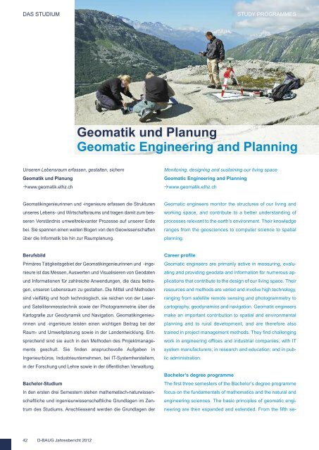
<strong>Geomatik</strong> <strong>und</strong> Planung<br />
Geomatic Engineering and Planning<br />
Unseren Lebensraum erfassen, gestalten, sichern<br />
<strong>Geomatik</strong> <strong>und</strong> Planung<br />
www.geomatik.ethz.ch<br />
Monitoring, designing and sustaining our living space<br />
Geomatic Engineering and Planning<br />
www.geomatik.ethz.ch<br />
<strong>Geomatik</strong>ingenieurinnen <strong>und</strong> -ingenieure erfassen die Strukturen<br />
unseres Lebens- <strong>und</strong> Wirtschaftsraums <strong>und</strong> tragen damit zum besseren<br />
Verständnis umweltrelevanter Prozesse auf unserer Erde<br />
bei. Sie spannen einen weiten Bogen von den Geowissenschaften<br />
über die Informatik bis hin zur Raumplanung.<br />
Geomatic engineers monitor the structures of our living and<br />
working space, and contribute to a better <strong>und</strong>erstanding of<br />
processes relevant to the earth’s environment. Their knowledge<br />
ranges from the geosciences to computer science to spatial<br />
planning.<br />
Berufsbild<br />
Primäres Tätigkeitsgebiet der <strong>Geomatik</strong>ingenieurinnen <strong>und</strong> -ingenieure<br />
ist das Messen, Auswerten <strong>und</strong> Visualisieren von Geodaten<br />
<strong>und</strong> Informationen für zahlreiche Anwendungen, die dazu beitragen,<br />
unseren Lebensraum zu gestalten. Die Mittel <strong>und</strong> Methoden<br />
sind vielfältig <strong>und</strong> hoch technologisch, sie reichen von der Laser<strong>und</strong><br />
Satellitenmesstechnik sowie der Photogrammetrie über die<br />
Kartografie zur Geodynamik <strong>und</strong> Navigation. <strong>Geomatik</strong>ingenieurinnen<br />
<strong>und</strong> -ingenieure leisten einen wichtigen Beitrag bei der<br />
Raum- <strong>und</strong> <strong>Umwelt</strong>planung sowie in der Landentwicklung. Entsprechend<br />
sind sie auch in den Methoden des Projektmanagements<br />
geschult. Sie finden anspruchsvolle Aufgaben in<br />
Ingenieurbüros, Industrieunternehmen, bei IT-Systemherstellern,<br />
in der Forschung <strong>und</strong> Lehre sowie in der öffentlichen Verwaltung.<br />
Bachelor-Studium<br />
In den ersten drei Semestern stehen mathematisch-naturwissenschaftliche<br />
<strong>und</strong> ingenieurwissenschaftliche Gr<strong>und</strong>lagen im Zentrum<br />
des Studiums. Anschliessend werden die Gr<strong>und</strong>lagen der<br />
Career profile<br />
Geomatic engineers are primarily active in measuring, evaluating<br />
and providing geodata and information for numerous applications<br />
that contribute to the design of our living space. Their<br />
resources and methods are varied and involve high technology,<br />
ranging from satellite remote sensing and photogrammetry to<br />
cartography, geodynamics and navigation. Geomatic engineers<br />
make an important contribution to spatial and environmental<br />
planning and to rural development, and are therefore also<br />
trained in project management methods. They find challenging<br />
work in engineering offices and industrial companies; with IT<br />
system manufacturers; in research and education; and in public<br />
administration.<br />
Bachelor’s degree programme<br />
The first three semesters of the Bachelor’s degree programme<br />
focus on the f<strong>und</strong>amentals of mathematics and the natural and<br />
engineering sciences. The basic principles of geomatic engineering<br />
are then expanded and extended. From the fifth se-<br />
42 D-BAUG Jahresbericht <strong>2012</strong>