vii berichte von fachinstituten an universitäten und technischen
vii berichte von fachinstituten an universitäten und technischen
vii berichte von fachinstituten an universitäten und technischen

Sie wollen auch ein ePaper? Erhöhen Sie die Reichweite Ihrer Titel.
YUMPU macht aus Druck-PDFs automatisch weboptimierte ePaper, die Google liebt.
366 Fachinstitute <strong>an</strong> Universitäten <strong>und</strong> Hochschulen<br />
navigation. The so called BaiCES simulator is based on the<br />
commercial simulation environment, ML-Designer, from<br />
the Mission Level Design GmbH.<br />
This simulation infrastructure enables the user to build up<br />
a simulation application graphically, by drag <strong>an</strong>d drop<br />
models from the model library into the simulation build up<br />
window <strong>an</strong>d connecting their in- <strong>an</strong>d output ports. Each<br />
model represents a certain partition of a GNSS System, like<br />
the satellite orbit, the satellite signal, the receiver, the user<br />
environment (terrain data) or the positioning algorithm. A<br />
model library was developed which consists mainly of the<br />
algorithms which were implemented in existing GNSS<br />
simulation tools in the past. The main adv<strong>an</strong>tage of this<br />
approach is the enormous flexibility <strong>an</strong>d tr<strong>an</strong>sparency to the<br />
user of this simulator. The model library c<strong>an</strong> be extended<br />
at <strong>an</strong>y time to include new models or new research results<br />
in satellite navigation.<br />
C-NAV Study<br />
Although not considered for the first generation of Europe<strong>an</strong><br />
Galileo satellites, the (additional) use of C-b<strong>an</strong>d frequencies<br />
is currently topic of <strong>an</strong> ESA study which started in late 2007<br />
<strong>an</strong>d is to be completed by 2008. The Institute was already<br />
involved in a similar study a couple of years ago f<strong>und</strong>ed by<br />
national institutions. A future C-b<strong>an</strong>d signal could use the<br />
frequency of 5.019 GHz, thus offering a b<strong>an</strong>dwidth of 20<br />
MHz in a frequency b<strong>an</strong>d not yet overloaded by other signal<br />
sources. Application of C-B<strong>an</strong>d navigation signals provides<br />
both adv<strong>an</strong>tages <strong>an</strong>d drawbacks. At C-b<strong>an</strong>d, the increased<br />
free space loss represents the most signific<strong>an</strong>t issue.<br />
Increased signal attenuation due to foliage attenuation <strong>an</strong>d<br />
in case of heavy rain c<strong>an</strong> also be considered as drawbacks.<br />
However, small ionospheric effects <strong>an</strong>d technological<br />
progress will likely bal<strong>an</strong>ce some of the disadv<strong>an</strong>tages from<br />
a long term point of view. The main intention of this study<br />
is to provide <strong>an</strong> <strong>an</strong>alysis of the effects of C-b<strong>an</strong>d frequencies<br />
on the navigation process <strong>an</strong>d to define appropriate signals<br />
<strong>an</strong>d emission procedures to overcome the inherent<br />
drawbacks of C-b<strong>an</strong>d, investigate the current state of<br />
hardware technology suitable for C-b<strong>an</strong>d navigation, <strong>an</strong>d<br />
to define services for a C-b<strong>an</strong>d GAILLEO system.<br />
Gnss Receiver Development<br />
GNSS Hardware Receiver<br />
An experimental dual frequency (L1 C/A <strong>an</strong>d L2 civil<br />
signal) real-time kinematic (RTK) receiver is currently<br />
developed at the Institute of Geodesy <strong>an</strong>d Navigation in<br />
collaboration with FhGIIS (Frauenhofer Institute for<br />
Integrated Circuits) <strong>an</strong>d IfEN GmbH. This investigation is<br />
f<strong>und</strong>ed within the scope of a research project in contract with<br />
DLR (Germ<strong>an</strong> Aerospace Centre). The development<br />
includes a large number of paper studies to investigate<br />
existing RTK receiver designs, new bo<strong>und</strong>ary conditions<br />
due to the Galileo system <strong>an</strong>d due to GPS modernization.<br />
Also new possibilities to integrate the internet, low cost INS<br />
<strong>an</strong>d GIS into the RTK receiver have been explored. The<br />
most exciting part of the project is the development of a<br />
breadboard receiver using a wideb<strong>an</strong>d L1 CA/L2CS frontend.<br />
Signal processing is performed by a FPGA card<br />
plugged into a PC <strong>an</strong>d by a software correlator. RTK<br />
positions are calculated by fixing the integer ambiguities<br />
using the LAMBDA method. The positioning software runs<br />
<strong>und</strong>er the Windows Operating System <strong>an</strong>d has interfaces<br />
to the FPGA <strong>an</strong>d the software correlator. By using this dual<br />
correlator approach, software <strong>an</strong>d hardware correlation<br />
techniques c<strong>an</strong> be directly compared.<br />
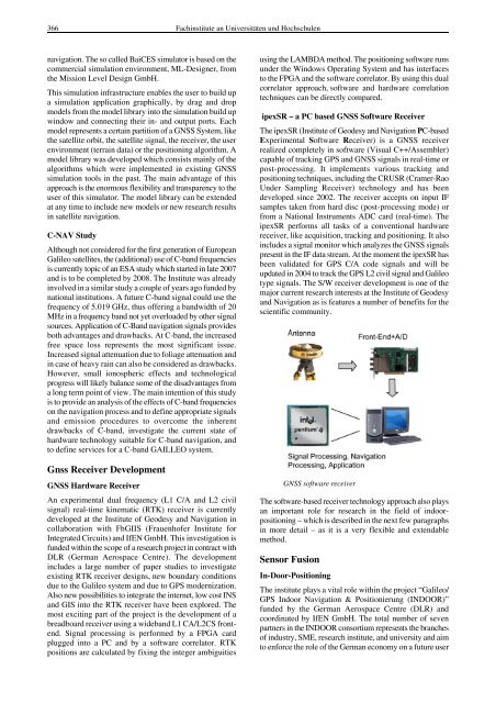
ipexSR – a PC based GNSS Software Receiver<br />
The ipexSR (Institute of Geodesy <strong>an</strong>d Navigation PC-based<br />
Experimental Software Receiver) is a GNSS receiver<br />
realized completely in software (Visual C++/Assembler)<br />
capable of tracking GPS <strong>an</strong>d GNSS signals in real-time or<br />
post-processing. It implements various tracking <strong>an</strong>d<br />
positioning techniques, including the CRUSR (Cramer-Rao<br />
Under Sampling Receiver) technology <strong>an</strong>d has been<br />
developed since 2002. The receiver accepts on input IF<br />
samples taken from hard disc (post-processing mode) or<br />
from a National Instruments ADC card (real-time). The<br />
ipexSR performs all tasks of a conventional hardware<br />
receiver, like acquisition, tracking <strong>an</strong>d positioning. It also<br />
includes a signal monitor which <strong>an</strong>alyzes the GNSS signals<br />
present in the IF data stream. At the moment the ipexSR has<br />
been validated for GPS C/A code signals <strong>an</strong>d will be<br />
updated in 2004 to track the GPS L2 civil signal <strong>an</strong>d Galileo<br />
type signals. The S/W receiver development is one of the<br />
major current research interests at the Institute of Geodesy<br />
<strong>an</strong>d Navigation as is features a number of benefits for the<br />
scientific community.<br />
GNSS software receiver<br />
The software-based receiver technology approach also plays<br />
<strong>an</strong> import<strong>an</strong>t role for research in the field of indoorpositioning<br />
– which is described in the next few paragraphs<br />
in more detail – as it is a very flexible <strong>an</strong>d extendable<br />
method.<br />
Sensor Fusion<br />
In-Door-Positioning<br />
The institute plays a vital role within the project “Galileo/<br />
GPS Indoor Navigation & Positionierung (INDOOR)”<br />
f<strong>und</strong>ed by the Germ<strong>an</strong> Aerospace Centre (DLR) <strong>an</strong>d<br />
coordinated by IfEN GmbH. The total number of seven<br />
partners in the INDOOR consortium represents the br<strong>an</strong>ches<br />
of industry, SME, research institute, <strong>an</strong>d university <strong>an</strong>d aim<br />
to enforce the role of the Germ<strong>an</strong> economy on a future user