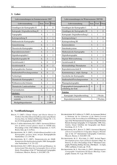
262 Fachinstitute <strong>an</strong> Universitäten <strong>und</strong> Hochschulen 3. Lehre Lehrver<strong>an</strong>staltungen im Sommersemester 2007 Lehrver<strong>an</strong>staltung Sem. Vorl. Übung Gr<strong>und</strong>lagen der Kartographie II 2. 2 0 Kartograph. Originalherstellung II 2. 1 1 Topographie 4. 1 1 Kartengestaltung II 4. 1 1 Mathematische Kartographie 4. 2 1 Generalisierung 6. 1 1 Theoretische Kartographie 6. 2 0 Reproduktionstechnik I 4. 2 1 Digitalkartographie I 4. 1 1 Digitalkartographie III 6. 2 1 Geoinformatik I 6. 0 2 Geoinformatik II 8. 0 2 Kartographisches Seminar 6. 0 1 Studienarbeit/Forschungsseminar 8. 0 2 Technologie 6. 2 1 Thematische Kartographie I 6. 2 1 Weltkartenwerke/Atl<strong>an</strong>ten 8. 1 1 Thematische L<strong>an</strong>desaufnahme 8. 1 1 Touristenkarten fakultativ: 8. 2 0 Einführung in die Kartosemiotik 8 1 0 Hochgebirgsexkursion 6 5 SWS 4. Veröffentlichungen BOLCH, T. (2007): Climate Ch<strong>an</strong>ge <strong>an</strong>d Glacier Retreat in Northern Tien Sh<strong>an</strong> (Kasachst<strong>an</strong>/Kyrgyzst<strong>an</strong>) using Remote Sensing Data. In: Global <strong>an</strong>d Pl<strong>an</strong>etary Ch<strong>an</strong>ge 56: 1-12, doi:10.1016/j.gloplacha.2006.07.009. BOLCH, T. & BUCHROITHNER, M. F. (2007): Automated Delineation of debris-covered glaciers based on ASTER data. Proceedings of the 27th EARSeL-Symposium, 4.-7.6.07, Bozen, Italy, pp. 6; in Press. BUCHROITHNER, M. F. (2007): Echtdreidimensionalität in der Kartographie: gerstern, heute, morgen. Kartographische Nachrichten, 5, S. 239-248. BUCHROITHNER, M. F. (2007): Tätigkeitsbericht der DGfK- Kommission Hochgebirgskartographie 2006. Kartographische Nachrichten, 4, S. 221-222. BUCHROITHNER, M. F. (2007): Between Gobi <strong>an</strong>d Himalaya: An Instructional Film about the Cartographic Oevre of Sven Hedin. Proceedings of the 23 rd International Cartographic Conference, Moscow, Russia, 4.-10.8.2007, CD. Lehrver<strong>an</strong>staltungen im Wintersemester 2007/08 Lehrver<strong>an</strong>staltung Sem. Vorl. Übung Gr<strong>und</strong>lagen der Kartographie I 1. 2 1 Gr<strong>und</strong>lagen der Kartographie III 3. 2 0 Kartograph. Originalherstellung I 1. 1 1 Kartengestaltung I 3. 2 0 Kartengestaltung III 5. 1 1 Kartenredaktion 5. 2 1 Datenb<strong>an</strong>ksysteme 3. 1 2 Mathematische Kartographie 5. 1 1 Digitalkartographie 5. 1 1 Digitale Bildverarbeitung 5. 1 1 Geoinformatik II 8. 0 2 Kleinmaßstäbige Themakarten 9. 1 1 Reproduktionstechnik II 5. 2 1 Kartennutzung u. empir. Kartogr. 9. 1 1 Geschichte der Kartographie 9. 1 1 Studienarbeit/Forschungsseminar 9. 0 2 Pl<strong>an</strong>ungskartographie 9. 1 1 Topographisch-kartographische Erschließung der Erde Praktika: 9. 1 1 Kartograph. Originalherstellung 1. 1 Woche Reproduktionstechnik 5. 2 Wochen BUCHROITHNER, M. F. & BOLCH, T. (2007): An Automated Method to Delineate the Ice Extension of the Debris-Covered Glaciers at Mt. Everest Based on ASTER Imagery. Proceedings of the 9th International Symposium on High Mountain Remote Sensing Cartography 14-22 September 2006, Graz, Austria, Grazer Schriften der Geographie <strong>und</strong> Raumforschung, 43, S. 71-78. BUCHROITHNER, M. F., BOLCH, T. (2007): Automated Mapping of Scree-Covered Glaciers Using Space Imagery. Proceedings of the 23 rd International Cartographic Conference, Moscow, Russia, 4.-10.8.2007, CD. BUCHROITHNER, M. F., WALTHER, S. (2007, Invited Paper): Development of new Types of Glacier Dynamics Maps. In: Petrovic, D. (Ed.): Proceedings of the 5 th Mountain Cartography Workshop, Bohinj, Slovenia, 29th March – 1st April, 2006, Ljublj<strong>an</strong>a, Croatia, pp. 19-26. BUCHROITHNER, M. F., WALTHER, S. (2007): Multiparametric Cartographic Visualisation Of Glacier Rheology. Cartographic Journal, 44, 4, pp. 304-312(9).
FLACH, B., BOLCH, T., BUCHROITHNER, M. F. (2007): Detection of Debris-Covered Glaciers – A Structural <strong>an</strong>d Statistical Analysis Approach. Proc. of the GLIMS Workshop, July 6, 2007, Perugia, Italy, in print. KOCH, W. G. (2007): Visualisierung, kartographische Gestaltung <strong>und</strong> visuelle kartographische Kommunikation. In: S. Tzschaschel, H. Wild, S. Lentz (Hrsg.): Visualisierung des Raumes. Karten machen – Macht der Karten, Leipzig 2007, Forum IfL, S. 91-101. KOCH, W. G. (2007): Beiträge zur wissenschaftlichen Kartographie. Contributions to scientific cartography. TUDpress, Dresden 2007 (329 S.). KOCH, W. G. (2007): Gotthard T<strong>an</strong>ner 1925-2007. In: Kartographische Nachrichten 57 (2007) 4, S. 216. LONDERSHAUSEN, K. & PRECHTEL, N. (2007): An Animated Presentation of the Dresden “Altai-GIS”. In: Petrovic, D. (Ed.): Proceedings of the 5 th Mountain Cartography Workshop, ICA, Commission on Mountain Cartography, Ljublj<strong>an</strong>a, Croatia, pp. 210-221. MEINEL, G., SCHUBERT, I., SIEDENTOP, S., BUCHROITHNER, M. (2007): Europäische Siedlungsstrukturvergleiche auf Basis <strong>von</strong> CORINE L<strong>an</strong>d Cover – Möglichkeiten <strong>und</strong> Grenzen. In: Schrenk, M., Popovich, V., Benedikt, J. (Hrsg.): To Pl<strong>an</strong> Is Not Enough. Proceedings REAL CORP 007, Wien, Österreich, Mai 2007, S. 645-656. SHINGAREVA, K. B., ZIMBELMAN, J., BUCHROITHNER, M. F., HARGITAI, H. I. (2007): The Realization of ICA Commission Projects on Pl<strong>an</strong>etary Cartography. cartographica, 40, 4, S. 105-114. SHINGAREVA, K., KRASNOPEVTSEVA, B. V., ZIMBELMAN, J. R., GOMEZ, R. P., HOEHNE, A. V., BUCHROITHNER, M. F., DORRER, E. (2007): A New Multilingual Glossary on Pl<strong>an</strong>etary Cartography. Proceedings of the 23 rd International Cartographic Conference, Moscow, Russia, 4.-10.8.2007, CD. SHINGAREVA, K. B., KRASNOPEVTSEVA, B. V., LEONENKO, S. M., BUCHROITHNER, M. F., FLEIS, M. E., STOOKE, P. (2007): Pl<strong>an</strong>etary Map Series: Current Project Status <strong>an</strong>d Near Future. Proceedings of the 23 rd International Cartographic Conference, Moscow, Russia, 4.-10.8.2007, CD. SULIEMAN, H. M., BUCHROITHNER, M. F. (2007): Assessment of the Restoration Potential of the Ab<strong>an</strong>doned Agricultural L<strong>an</strong>d in Doka Area, Eastern Sud<strong>an</strong> Using Remote Sensing Imagery <strong>an</strong>d GIS. IEEE Proceedings for International Workshop for Sustainable Development, 14 – 16 November 2005, Rabat, Morocco. 1-4244-0846-6/07 SULIEMAN, H. M., BUCHROITHNER, M. F. (2007): Multi-Temporal Classification of Ab<strong>an</strong>doned Agricultural L<strong>an</strong>d in Gadarif Region, Sud<strong>an</strong>, Using Original B<strong>an</strong>ds, Indices <strong>an</strong>d Feature Components of Spaceborne Imagery. IEEE Proceedings for Fourth International Workshop on the Analysis of Multitemporal Remote Sensing Images, July 18-20, 2007 Leuven, Belgium, 10.1109/MULTITEMP.2007.4293032. VASSENA, G., BUCHROITHNER, M. F., LANZI, C., GELMINI, M., BOLCH, T., LÖFFLER, J., WUNDRAM, D. (2007): A 3D Mixed Laser-Sc<strong>an</strong>ner <strong>an</strong>d Photogrammetry Survey Approach for High-Altitude Glacier Monitoring. Proceedings of IUGG XXIV General Assembly 2007, 2-13 July, Perugia, Italy, http://www.iugg2007perugia.it/webbook. WÄLDER, O., BUCHROITHNER, M. F. (2007): Stereo Viewing of Lenticular Foil Displays: A Geometric Analysis. Proceedings of the 23 rd International Cartographic Conference, Moscow, Russia, 4.-10.8.2007, CD. Technische Universität Dresden – Institut für Kartographie 263 WÄLDER, O. (2007): An application of the fuzzy theory in surface interpolation <strong>an</strong>d surface deformation <strong>an</strong>alysis. FSS (Fuzzy Sets <strong>an</strong>d Systems), 158, S. 1535-1545. WÄLDER, O. (2007): Spezielle statistische Testverfahren <strong>und</strong> ihre Anwendung in sozial-psychologischen Untersuchungen. AJS (Austri<strong>an</strong> Journal of Statistics), 36, 2, S. 1-12. WÄLDER, K., WÄLDER, O., RINKLEBE, J., MENZ, J. (2007): Estimation of soil properties with geostatistical methods in floodplains. Archives of Agronomy <strong>an</strong>d Sciences, im Druck. WÄLDER, O. (2007). On <strong>an</strong>alysis <strong>an</strong>d forecasting of surface movement <strong>an</strong>d deformation: Some AR-models <strong>an</strong>d their application. AVN (Allgemeine Vermessungs-Nachrichen), 3, S. 96- 100. WOLODTSCHENKO, A. (2007): Theoretical Cartography. Workshop on cartographic knowledge <strong>an</strong>d terminology. ICA News, 48, S. 10-11. WOLODTSCHENKO, A. (2007): Zur <strong>an</strong>gew<strong>an</strong>dten Kartosemiotik. In: "Cartography <strong>an</strong>d High School", Sbornik naukovyh prac, Schewtschenko University Kyiv, Ukraine, S. 9-13. WOLODTSCHENKO, A. (2007): Nationalatlas Deutschl<strong>an</strong>ds: ein kartosemiotisches Porträt. In: Wolodtschenko, A. <strong>und</strong> Schlichtm<strong>an</strong>n, H. (Hrsg.): Diskussionsbeiträge zur Kartosemiotik <strong>und</strong> zur Theorie der Kartographie, Intern. Korrespondenz-Seminar, 10, Dresden, 56 S. WOLODTSCHENKO, A., ROTANOVA, I. N. (2007): Ecological atlascartosemiotics: New academic discipline. ICA Workshop "Ecological Cartosemiotics <strong>an</strong>d Ecological Safety", 30.3. 2007, Kyiv, Ukraine, CD. WOLODTSCHENKO, A. (2007): Zur Frage der realen <strong>und</strong> fiktiven Karten. Proceedings of the 9 th IASS-Conference “Comminication: Underst<strong>an</strong>ding/Mis<strong>und</strong>erst<strong>an</strong>ding”, 11.-17.7.2007, Helsinki, Finl<strong>an</strong>d, CD. WOLODTSCHENKO, A. (2007): On Cartosemiotic Competence <strong>an</strong>d Knowledge. Proceedings of the 23 rd International Cartographic Conference, 6.-10.8.2007, Moscow, Russia, CD. WOLODTSCHENKO, A.; BECONYTE, G.; CESNULEVICIUS, A.: Vilnius Seminars on Cartosemiotic: Ideas, Experiences <strong>an</strong>d Perspectives. Proceedings of the 23 rd International Cartographic Conference, 4.-10.8.2007, Moscow, Russia, CD. WOLODTSCHENKO, A., SCHLICHTMANN, H. (2007): Presentation of a Cartosemiotic Glossary. Proceedings of the 23 rd International Cartographic Conference, 6.-10.8.2007, Moscow, Russia, CD. WOLODTSCHENKO, A., FORNER, T.: Conception of the Pocket- Atlas: Prehistoric Maps in Europe<strong>an</strong> Museums. In: Proceedings of the 23 rd International Cartographic Conference, 6- 10.8.2007, Moscow, Russia, CD. WOLODTSCHENKO, A., KELGENBAEVA, K. (2007): Cartosemiotic Analysis of the Maps of Nature of the Kyrgyz National Atlas. In: Proceedings of the 23 rd International Cartographic Conference, 6-10.8.2007, Moscow, Russia, CD. WOLODTSCHENKO, A., GORDYEYEV, A. (2007): Cartosigmatic Analysis of Atlases (On <strong>an</strong> example of <strong>an</strong>alog atlases of S<strong>an</strong>kt Petersburg/Leningrad). In: Proceedings of the 23 rd International Cartographic Conference, 6-10.8.2007, Moscow, Russia, CD. WOLODTSCHENKO, A., ROTANOVA, I. N. (2007): Cartosemiotic <strong>an</strong>alysis of Barnaul city atlas. In: Proceedings of the 23 rd International Cartographic Conference, 6-10.8.2007, Moscow, Russia, CD. WOLODTSCHENKO, A. <strong>und</strong> SCHLICHTMANN, H. (Hrsg., 2007): Diskussionsbeiträge zur Kartosemiotik <strong>und</strong> zur Theorie der Kartographie. Intern. Korrespondenz-Seminar, 10, Dresden, 56 S.
- Seite 1 und 2:
VII BERICHTE VON FACHINSTITUTEN AN
- Seite 3 und 4:
Organisationsübersicht und Persona
- Seite 5 und 6:
Institut für Geodäsie und Geoinfo
- Seite 7 und 8:
TU Berlin - Institut für Geodäsie
- Seite 9 und 10:
B) Fachgebiet Geodäsie und Ausglei
- Seite 11 und 12:
C) Fachgebiet Satellitengeodäsie u
- Seite 13 und 14: D) Fachgebiet Planetengeodäsie 1.
- Seite 15 und 16: 1. Personal Lehrkörper Arbeitsgrup
- Seite 17 und 18: Universität Bonn - Institut für G
- Seite 19 und 20: Universität Bonn - Institut für G
- Seite 21 und 22: Universität Bonn - Institut für G
- Seite 23 und 24: Universität Bonn - Institut für G
- Seite 25 und 26: 5. Diplomarbeiten Universität Bonn
- Seite 27 und 28: Universität Bonn - Institut für G
- Seite 29 und 30: Universität Bonn - Institut für G
- Seite 31 und 32: Universität Bonn - Institut für G
- Seite 33 und 34: Personal Professur für Vermessungs
- Seite 35 und 36: tierung der Bildaufnahmen soll dabe
- Seite 37 und 38: LINKE, H. J.: Der Baugrund in der G
- Seite 39 und 40: 4. Lehre Technische Universität Da
- Seite 41 und 42: Institut für Physikalische Geodäs
- Seite 43 und 44: Institut für Physikalische Geodäs
- Seite 45 und 46: Institut für Physikalische Geodäs
- Seite 47 und 48: Forschungsprojekte „Kalibrierung
- Seite 49 und 50: Hánek, Dr. Prochazka, Dr. Svec) wa
- Seite 51 und 52: DGK-Sitzung, St. Gilgen (Österreic
- Seite 53 und 54: Juni - Juli 2007 Juni - August 2007
- Seite 55 und 56: 22.10.-26.10.2007, IAU Symposium 24
- Seite 57 und 58: Référence Spatio-Temporels, 17.09
- Seite 59 und 60: Technische Universität Dresden - I
- Seite 61 und 62: 6. Diplomarbeiten/Dissertationen Te
- Seite 63: Karten für Blinde und Sehbehindert
- Seite 67 und 68: - Mitglied der Strukturkommission d
- Seite 69 und 70: NEUNER H.: VDV-Hochschulreferent se
- Seite 71 und 72: KUTTERER, H., SCHUH, W.-D. (2007):
- Seite 73 und 74: Die Modellierung der Mauer geschieh
- Seite 75 und 76: Geodätische Deformationsanalysen u
- Seite 77 und 78: Leibniz Universität Hannover - Geo
- Seite 79 und 80: für die Genauigkeit von TLS münde
- Seite 81 und 82: konnte eine sehr gute Übereinstimm
- Seite 83 und 84: Parameter für Modelle des (Fehler-
- Seite 85 und 86: JARECKI, F.: Third International GO
- Seite 87 und 88: STEFFEN, H., VINK, A., REINHARDT, L
- Seite 89 und 90: Institut für Photogrammetrie und G
- Seite 91 und 92: Leibniz Universität Hannover - Ins
- Seite 93 und 94: Mitberichte Leibniz Universität Ha
- Seite 95 und 96: Institut für Kartographie und Geoi
- Seite 97 und 98: Institut für Kartographie und Geoi
- Seite 99 und 100: I. Vorstellung des Instituts Geodä
- Seite 101 und 102: - Einfluss der Elliptizität der Er
- Seite 103 und 104: ZÜRN, W. / EXß, J. / STEFFEN, H.
- Seite 105 und 106: - Teilprojekt 2 „Erstellung eines
- Seite 107 und 108: Institut für Photogrammetrie und F
- Seite 109 und 110: Universität Karlsruhe (TH) - Insti
- Seite 111 und 112: Universität Karlsruhe (TH) - Insti
- Seite 113 und 114: Universität Karlsruhe (TH) - Insti
- Seite 115 und 116:
Universität Karlsruhe (TH) - Insti
- Seite 117 und 118:
Universität Karlsruhe (TH) - Insti
- Seite 119 und 120:
noch nicht abgeschlossen. Universit
- Seite 121 und 122:
Universität Karlsruhe (TH) - Insti
- Seite 123 und 124:
Mitarbeiter Dr.-Ing. H. KARMANN, Ak
- Seite 125 und 126:
2. Herausgeberschaften WUNDERLICH,
- Seite 127 und 128:
10. Teilnahme an wissenschaftlichen
- Seite 129 und 130:
Fachgebiet Geoinformationssysteme 2
- Seite 131 und 132:
8. Teilnahme an wissenschaftlichen
- Seite 133 und 134:
MASUM, F. (2007): Land development
- Seite 135 und 136:
MAGEL, H.; BOCK, H.; FRANKE, S.; KA
- Seite 137 und 138:
1. Mitarbeiter Institut für Astron
- Seite 139 und 140:
TU München - Astronomische und Phy
- Seite 141 und 142:
TU München - Astronomische und Phy
- Seite 143 und 144:
TU München - Astronomische und Phy
- Seite 145 und 146:
TU München - Astronomische und Phy
- Seite 147 und 148:
In Bearbeitung Astronomische und Ph
- Seite 149 und 150:
3. Lehrstuhl für Kartographie Univ
- Seite 151 und 152:
Urban Remote Sensing Joint event: U
- Seite 153 und 154:
TU München - Lehrstuhl für Method
- Seite 155 und 156:
ISPRS Editorial Advisory Board Memb
- Seite 157 und 158:
Herausgeberschaften MENG L, HEIPKE
- Seite 159 und 160:
1. Organisationsübersicht 1.1 Leit
- Seite 161 und 162:
Aufbau einer "Integrated African He
- Seite 163 und 164:
The institute of geodesy and naviga
- Seite 165 und 166:
Spirent STR 4760 GPS simulator The
- Seite 167 und 168:
objectives. Most of the group membe
- Seite 169 und 170:
segment market of combined GPS/Gali
- Seite 171 und 172:
APL Flight - Testing with Do 128 re
- Seite 173 und 174:
Gravimetry Apart from the airborne
- Seite 175 und 176:
Organisation und Personal 1 Institu
- Seite 177 und 178:
Universität der Bundeswehr - Münc
- Seite 179 und 180:
2. Ausgewählte universitäre, nati
- Seite 181 und 182:
Examination of the phenological cha
- Seite 183 und 184:
Demsar, University of Maynooth (Hrs
- Seite 185 und 186:
Personnel Head of Institute SNEEUW
- Seite 187 und 188:
the space-time-sampling have been s
- Seite 189 und 190:
Figure 7: Residual potential of 6 b
- Seite 191 und 192:
In June 2003 the ground track is sp
- Seite 193 und 194:
With a normal observed accuracy of
- Seite 195 und 196:
Meeting of the Satellite Division,
- Seite 197 und 198:
SCHÖNHERR H: Amtliches Vermessungs
- Seite 199 und 200:
1. Personal Institut für Anwendung
- Seite 201 und 202:
4. Forschung und Entwicklung Univer
- Seite 203 und 204:
Abb. 5: PoGuide - Simulator Univers
- Seite 205 und 206:
Universität Stuttgart - Institut f
- Seite 207 und 208:
Universität Stuttgart - Institut f
- Seite 209 und 210:
Universität Stuttgart - Institut f
- Seite 211 und 212:
Personnel Head of Institute Prof. D
- Seite 213 und 214:
Education Diplomstudiengang Geodesi
- Seite 215:
7. Vorträge Bauhaus-Universität W