vii berichte von fachinstituten an universitäten und technischen
vii berichte von fachinstituten an universitäten und technischen
vii berichte von fachinstituten an universitäten und technischen

Sie wollen auch ein ePaper? Erhöhen Sie die Reichweite Ihrer Titel.
YUMPU macht aus Druck-PDFs automatisch weboptimierte ePaper, die Google liebt.
390 Fachinstitute <strong>an</strong> Universitäten <strong>und</strong> Hochschulen<br />
Figure 12: Amazon <strong>an</strong>d G<strong>an</strong>ges catchments show signific<strong>an</strong>t variations within the time series generated using different filters<br />
Survey of vertical gravity gradients in Baden-Württemberg<br />
<strong>an</strong>d Bavaria for GOCE-GRAND II project<br />
For the GOCE GRAND II validation project the B<strong>und</strong>esamt<br />
für Kartographie <strong>und</strong> Geodäsie (BKG) measured new<br />
gravity data sets of existing gravity points all over Germ<strong>an</strong>y.<br />
For 14 of these observation points in Baden-Württemberg<br />
<strong>an</strong>d Bavaria the Institute of Geodesy supported the BKG<br />
in the gradient measurements. The points were surveyed<br />
with the absolute gravimeter Micro-g A10 of the BKG. The<br />
sensor height of the A10 is approximately 70cm. To bring<br />
down the absolute gravity value to the benchmark information<br />
about the accurate local gravity gradient is required.<br />
This is one field in the r<strong>an</strong>ge of applications of a gravimeter<br />
like the Scintrex CG-5.<br />
All measurements were accomplished within 3 long survey<br />
days. Pl<strong>an</strong>ning the measurements was done on basis of the<br />
official drafts of the survey offices, new snapshots made<br />
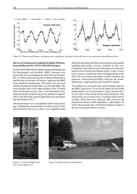
Figure 13: Tripod of BKG with<br />
CG-5 in the upper level<br />
Figure 14: Measurement at Buchenberg<br />
during the preceding absolute measurements <strong>an</strong>d st<strong>an</strong>dard<br />
mapping-<strong>an</strong>d-routing services available on the web.<br />
Compared to the drafts the up to date photos were the best<br />
help on site to find the benchmarks easily. It took 2 sometimes<br />
3 hours to reach each of the widespread points in the<br />
field. This was mostly dependent on traffic situation <strong>an</strong>d<br />
tr<strong>an</strong>sport connection/accessibility between the points.<br />
Measuring a single gradient took aro<strong>und</strong> 45 minutes.<br />
The gradient was surveyed with a special tripod, made by<br />
the BKG. Each of the 2 levels of the tripod c<strong>an</strong> be leveled<br />
independently. So it was possible to ‘jump’ between the 2<br />
levels to take 3 observations per level fast <strong>an</strong>d precise. One<br />
observation was averaged out of 3 readings which took 45<br />
seconds. These data were <strong>an</strong>alyzed, drift corrected <strong>an</strong>d<br />
checked for outliers (Grubbs algorithm). A plot (Figure 15)<br />
of the measurement data verified the numerical output of<br />
the gravity gradient <strong>an</strong>d its accuracy.