Wasser im Gartenbau : Tagungsband zum Statusseminar am 9 ... - vTI
Wasser im Gartenbau : Tagungsband zum Statusseminar am 9 ... - vTI
Wasser im Gartenbau : Tagungsband zum Statusseminar am 9 ... - vTI

Sie wollen auch ein ePaper? Erhöhen Sie die Reichweite Ihrer Titel.
YUMPU macht aus Druck-PDFs automatisch weboptimierte ePaper, die Google liebt.
Landbauforschung – Sonderheft 328 (2009) 17<br />
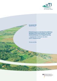
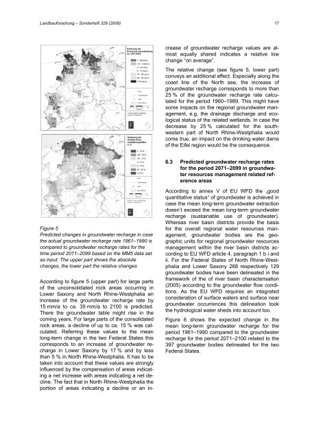
Figure 5<br />
Predicted changes in groundwater recharge in case<br />
the actual groundwater recharge rate 1961–1990 is<br />
compared to groundwater recharge rates for the<br />
t<strong>im</strong>e period 2071–2099 based on the MM5 data set<br />
as input. The upper part shows the absolute<br />
changes, the lower part the relative changes<br />
According to figure 5 (upper part) for large parts<br />
of the unconsolidated rock areas occurring in<br />
Lower Saxony and North Rhine-Westphalia an<br />
increase of the groundwater recharge rate by<br />
15 mm/a to ca. 35 mm/a to 2100 is predicted.<br />
There the groundwater table might rise in the<br />
coming years. For large parts of the consolidated<br />
rock areas, a decline of up to ca. 15 % was calculated.<br />
Referring these values to the mean<br />
long-term change in the two Federal States this<br />
corresponds to an increase of groundwater recharge<br />
in Lower Saxony by 17 % and by less<br />
than 5 % in North Rhine-Westphalia. It has to be<br />
taken into account that these values are strongly<br />
influenced by the compensation of areas indicating<br />
a net increase with areas indicating a net decline.<br />
The fact that in North Rhine-Westphalia the<br />
portion of areas indicating a decline or an in-<br />
crease of groundwater recharge values are almost<br />
equally shared indicates a relative low<br />
change “on average”.<br />
The relative change (see figure 5, lower part)<br />
conveys an additional effect. Especially along the<br />
coast line of the North see, the increase of<br />
groundwater recharge corresponds to more than<br />
25 % of the groundwater recharge rate calculated<br />
for the period 1960–1989. This might have<br />
some <strong>im</strong>pacts on the regional groundwater management,<br />
e.g. the drainage discharge and ecological<br />
status of the related wetlands. In case the<br />
decrease by 25 % calculated for the southwestern<br />
part of North Rhine-Westphalia would<br />
come true, an <strong>im</strong>pact on the drinking water d<strong>am</strong>s<br />
of the Eifel region would be the consequence.<br />
6.3 Predicted groundwater recharge rates<br />
for the period 2071–2099 in groundwater<br />
resources management related reference<br />
areas<br />
According to annex V of EU WFD the „good<br />
quantitative status“ of groundwater is achieved in<br />
case the mean long-term groundwater extraction<br />
doesn’t exceed the mean long-term groundwater<br />
recharge (sustainable use of groundwater).<br />
Whereas river basin districts provide the basis<br />
for the overall regional water resources management,<br />
groundwater bodies are the geographic<br />
units for regional groundwater resources<br />
management within the river basin districts according<br />
to EU WFD article 4, paragraph 1 b i and<br />
ii. For the Federal States of North Rhine-Westphalia<br />
and Lower Saxony 268 respectively 129<br />
groundwater bodies have been delineated in the<br />
fr<strong>am</strong>ework of the of river basin characterisation<br />
(2005) according to the groundwater flow conditions.<br />
As the EU WFD requires an integrated<br />
consideration of surface waters and surface near<br />
groundwater occurrences this delineation took<br />
the hydrological water sheds into account too.<br />
Figure 6 shows the expected change in the<br />
mean long-term groundwater recharge for the<br />
period 1961–1990 compared to the groundwater<br />
recharge for the period 2071–2100 related to the<br />
397 groundwater bodies delineated for the two<br />
Federal States.