Figure I Generalized map of the Wilbur Mining ... - University of Utah
Figure I Generalized map of the Wilbur Mining ... - University of Utah
Figure I Generalized map of the Wilbur Mining ... - University of Utah

You also want an ePaper? Increase the reach of your titles
YUMPU automatically turns print PDFs into web optimized ePapers that Google loves.
Geo<strong>the</strong>rmal Resources Council, TRANSACTIONS, Vol. 3 Septetrber 1979<br />
KLAMATH FALLS GEOTHERMAL HEATINR DISTRICT<br />
John H. Lund. Paul J. Lienau. G. Gene Culver. Charles V. Hiqbee<br />
ABSTRACT<br />
The City <strong>of</strong> Klamath Falls is proposing to<br />
construct a geo<strong>the</strong>rmal district heating project.<br />
Initially, <strong>the</strong> systera will heat 14 governraent<br />
buildings (Phase I) in <strong>the</strong> downtown area, subsequently<br />
expanded to heat 11 blocks (Phase II),<br />
and <strong>the</strong>n to heat <strong>the</strong> entire 54-block central<br />
business district (Phase III). Production wells<br />
will be drilled along <strong>the</strong> east boundary <strong>of</strong> <strong>the</strong><br />
City, estimated to supply over 220°F water. A<br />
primary 8-inch diameter insulated steel pipeline<br />
placed in a concrete tunnel will supply geo<strong>the</strong>rmal<br />
fluid to a central heat exchange facility at <strong>the</strong><br />
County Museum Building. Two plate heat exchangers<br />
will provide <strong>the</strong> necessary load for <strong>the</strong> initial 14<br />
buildings. An injection well is located next to<br />
this facility. A closed loop secondary pipeline<br />
will supply heat to <strong>the</strong> 14 buildings at 200°F.<br />
This line will consist <strong>of</strong> buried insulated fiberglass<br />
reinforced pipe. The capital cost <strong>of</strong> <strong>the</strong><br />
system (Phase I) will be $1.4 million giving an<br />
equivalent annual capital, operation, and maintenance<br />
cost over a 20-year period <strong>of</strong> $150,000.<br />
Phase II cost <strong>of</strong> geo<strong>the</strong>rmal energy is estimated<br />
at $0.29 per <strong>the</strong>rm, whereas <strong>the</strong> equivalent<br />
annual fossil fuel cost is estimated at $0.94 per<br />
<strong>the</strong>rm.<br />
INTRODUCTION<br />
The purpose <strong>of</strong> <strong>the</strong> 1977 Field Experiment<br />
contract awarded under PON EG-77-N-03-1553 to <strong>the</strong><br />
City <strong>of</strong> Klamath Falls, Oregon, is to design, construct,<br />
and initiate operation <strong>of</strong> a geo<strong>the</strong>rmal<br />
space heating district in <strong>the</strong> central business<br />
district <strong>of</strong> <strong>the</strong> City. This direct utilization<br />
project is for a City-owned and operated system,<br />
initially serving 14 City. County, State, and<br />
Federal <strong>of</strong>fice buildings (Phase I), with initial<br />
expansion to serve 11 blocks <strong>of</strong> commercial buildings<br />
along <strong>the</strong> pipeline route for <strong>the</strong> 14 buildings<br />
(Phase II), with subsequent expansion to commercial<br />
buildings on 54 city blocks in <strong>the</strong> central<br />
business" district (Phase III). The project will<br />
include production wells, injection wel1(s),<br />
transmission lines, controls, and retr<strong>of</strong>itting<br />
equipment for <strong>the</strong> governmental buildings.<br />
LLC Geo<strong>the</strong>rmal Consultants<br />
Klamath Falls. Oregon<br />
381<br />
PART I<br />
GEOLOGY. DISTRICT BOUNDARIES, & PRODUCTION FIELD<br />
Geology and Hydrology<br />
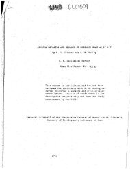
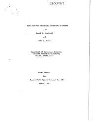
The Klamath Falls KGRA is located near <strong>the</strong><br />
east side and center <strong>of</strong> <strong>the</strong> Klamath Basin, a<br />
northwesterly-oriented graben. The Klamath Falls<br />
urban area is located in <strong>the</strong> nor<strong>the</strong>rn and largest<br />
portion <strong>of</strong> <strong>the</strong> KGRA. The main hot water well<br />
area is located adjacent to <strong>the</strong> eastern fault<br />
scarp, over fault blocks that are slightly<br />
tilted and raised above <strong>the</strong> central portion <strong>of</strong><br />
<strong>the</strong> graben (<strong>Figure</strong> 1). The principal geologic<br />
formations are lava flows, volcanic breccia<br />
(including labilli), locally designated "cinders,"<br />
and extensive deposits <strong>of</strong> lacustrine diatomite<br />
and tuffaceous siltstones and sandstones.<br />
\<strong>of</strong>i^GON_iNSTt r.ur^<br />
.£Lt. W.rkU T£M.r..TUIt£<br />
,17 4000' CLCVATIOH<br />
wareit WELL AREA<br />
NOAftr lrEup>i00'f.i<br />
ISO' f. tVATER<br />
\ aouKOdRr<br />
ZOO'r WATER<br />
BOUNDARr<br />
FIGURE 1<br />
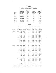
Well Water Temperature at 4000' Elevation