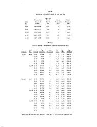
Figure I Generalized map of the Wilbur Mining ... - University of Utah
Figure I Generalized map of the Wilbur Mining ... - University of Utah
Figure I Generalized map of the Wilbur Mining ... - University of Utah

You also want an ePaper? Increase the reach of your titles
YUMPU automatically turns print PDFs into web optimized ePapers that Google loves.
Natural and man-made features were <strong>the</strong> primary<br />
controlling items. These included <strong>the</strong> two<br />
lakes, Link River, main ridge lines, <strong>the</strong> railroad<br />
and <strong>the</strong> "A" canal. Any <strong>of</strong> <strong>the</strong>se items would be<br />
costly to cross. For this reason <strong>the</strong> local<br />
distribution system for a district should fall<br />
within <strong>the</strong>se boundaries and only major supply<br />
lines would cross <strong>the</strong>ra at carefully selected<br />
points. City political boundaries did control<br />
<strong>the</strong> district locations to a degree, mainly to<br />
simplify future administration.<br />
<strong>Figure</strong> 2 is a generalized <strong>map</strong> <strong>of</strong> <strong>the</strong> urban<br />
area showing <strong>the</strong> approximate district boundaries.<br />
The district areas increase with distance from<br />
<strong>the</strong> central business district, due to <strong>the</strong> reduction<br />
in heating (population) density in <strong>the</strong><br />
suburban areas. Heating loads for each district<br />
have not been determined, however it is estimated<br />
that <strong>the</strong> majority are approximately equal.<br />
FIGURE 2<br />
Heating District Boundaries<br />
Based on discussions with City planning<br />
<strong>of</strong>ficials, a priority was given each district<br />
as to its probable inclusion into <strong>the</strong> system.<br />
Thus districts labeled "1" on <strong>Figure</strong> 2 would be<br />
developed first. "2" second, and so forth. Districts<br />
with priorities "1" and "2" have <strong>the</strong>ir<br />
boundaries fairly precisely determined for planning<br />
purposes, whereas priorities "5" and "6" have<br />
more flexible boundary locations due to <strong>the</strong> possible<br />
effects <strong>of</strong> future growth before <strong>the</strong>se districts<br />
come on-line.<br />
303<br />
Lund, et. al.<br />
A probable development schedule for each <strong>of</strong><br />
<strong>the</strong> priorities would be as follows:<br />
District Priority Tirae <strong>of</strong> Development<br />
1<br />
2<br />
3<br />
4<br />
5<br />
6<br />
0-2 years<br />
2-5<br />
5-10<br />
10-15<br />
>15<br />
>20<br />
It should be noted that two <strong>of</strong> <strong>the</strong> Districts<br />
immediately adjacent to <strong>the</strong> Commercial District<br />
were given a low "4" priority for development.<br />
This recognizes <strong>the</strong> fact that a great portion <strong>of</strong><br />
<strong>the</strong>se districts are already heated by individual<br />
wells, thus some <strong>of</strong> its heating needs are already<br />
being met by geo<strong>the</strong>rmal. Future development may<br />
be based on ei<strong>the</strong>r expanding <strong>the</strong> service load <strong>of</strong><br />
each existing well (from one to four houses, for<br />
example), or by providing a heating district<br />
similar to <strong>the</strong> o<strong>the</strong>r districts.<br />
Production Field Locations<br />
Several areas near or in <strong>the</strong> urban area have<br />
potential as production well sites. Each area<br />
was evaluated as to certain desirable characteristics,<br />
which included:<br />
1. proximity to users so as to minimize supply<br />
pipeline lengths;<br />
2. elevation head to provide gravity feed;<br />
3. availability <strong>of</strong> public land for development;<br />
and<br />
4. information on geo<strong>the</strong>rmal fluids existing in<br />
or adjacent to <strong>the</strong> site.<br />
Based on <strong>the</strong> above criteria and geologic information,<br />
seven areas have potential to supply <strong>the</strong><br />
necessary fluids for <strong>the</strong> near term or future<br />
development <strong>of</strong> <strong>the</strong> area. In many cases, additional<br />
geological, geophysical exploration, and/or<br />
drilling need to be performed to verify <strong>the</strong><br />
existence and characteristics <strong>of</strong> <strong>the</strong> resource.<br />
<strong>Figure</strong> 3 is a <strong>map</strong> to <strong>the</strong> same scale as <strong>the</strong><br />
geologic <strong>map</strong> indicating <strong>the</strong> seven sites. The<br />
numbers also indicate <strong>the</strong> order <strong>of</strong> recommended<br />
investigation and development <strong>of</strong> <strong>the</strong> sites. Site<br />
1 is discussed in detail.