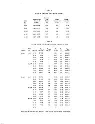
Figure I Generalized map of the Wilbur Mining ... - University of Utah
Figure I Generalized map of the Wilbur Mining ... - University of Utah
Figure I Generalized map of the Wilbur Mining ... - University of Utah

Create successful ePaper yourself
Turn your PDF publications into a flip-book with our unique Google optimized e-Paper software.
ABSTRiCT<br />
Ttte igeology <strong>of</strong> .ore deposits in c;arbonate' rocks in<br />
<strong>the</strong> eastern Great Basin gives );nsight into <strong>the</strong><br />
geology <strong>of</strong> present day geo<strong>the</strong>rmal reservoirs in<br />
carbonate rocks. The Cove Etirt KGRA is geologically<br />
similar to <strong>the</strong> Tintic mining district and<br />
<strong>the</strong> geblogy <strong>of</strong> <strong>the</strong> Carlin mine area suggests a<br />
cartxinate reservoir at <strong>the</strong> Beowawe KGHA. Carbonate<br />
geo<strong>the</strong>nnal reservoir's are unique in that fluids<br />
moving along fractares may leada calcite and, less<br />
<strong>of</strong>ten, dolcroite and <strong>the</strong>reto increase poKJsity and<br />
permeability.<br />
IMTRQDUCTHa)<br />
Geologists geherally recognize that most <strong>of</strong><br />
<strong>the</strong>: ore deposits <strong>of</strong> <strong>the</strong> •western U.S. are "fossilize3"<br />
geo<strong>the</strong>tmal systems. However, while ^ome<br />
detailed attention has teen given to <strong>the</strong> use <strong>of</strong><br />
<strong>the</strong> "porphyry copper model" in geo<strong>the</strong>rmal explbration,<br />
little attention has be^en given to o<strong>the</strong>r<br />
types <strong>of</strong> ore deposits found in areas being eicplored<br />
for geo<strong>the</strong>rmal reservoirs. Tlie purpose- <strong>of</strong> this<br />
paper is to point out similarities between ore<br />
deposits arid geoUiermal rfeservoirs in carbonate<br />
rocks in <strong>the</strong> eastem Great Basin and to indicate<br />
some <strong>of</strong> <strong>the</strong> unique problems_ and features <strong>of</strong> carbonate<br />
geo<strong>the</strong>rmal reservoirs. Two major mining<br />
districts and two *major geo<strong>the</strong>nnal prospects are<br />
discussed telbw. "Hieir bdmparison is made possible<br />
as a result <strong>of</strong> data from exploratory geo<strong>the</strong>nnal<br />
wells having been purchased by <strong>the</strong> Departinent <strong>of</strong><br />
Enetgy ard made available throiqh <strong>the</strong> <strong>University</strong> <strong>of</strong><br />
<strong>Utah</strong> Research Institute (UURI).<br />
The only"producing carbonate geo<strong>the</strong>rmal reservoirs<br />
at this time are <strong>the</strong> Lardarello arid Mt.<br />
Amiata fields in. Italy Vihere production is from<br />
highly permeable, fractured carbonates^ capped- by<br />
shaly fiysch facies which have beeti thrust over<br />
<strong>the</strong> carbonates (Gelati, et al., 1975). While<br />
space does not permit a <br />
silver, copper and gold ores valued at oyer $568<br />
million at th.e time <strong>of</strong> ptbductibn (Morris and<br />
Mogensen, 1978). The ore bodies <strong>of</strong>, <strong>the</strong> district<br />
consist <strong>of</strong> both massive, irregular replacements<br />
and replacement -veins ih folded and faulted<br />
Paleozoic limestones and dolan ites and open space<br />
fillings in narrower fissure" veins in Paleozoic<br />
quartzites arid Tertiary igneous rocks. The ore'<br />
bodies are believed to have been deposited by<br />
hydro<strong>the</strong>rmal fluids following a period <strong>of</strong> major<br />
vblcanism in <strong>the</strong> East Tintic Mountairis which took,<br />
place iri <strong>the</strong> Oligocene, eridlng about 31.5: million<br />
years ago. Itife vblcanic activity was centered a<br />
few miles south <strong>of</strong> <strong>the</strong> preserit mining district and<br />
in <strong>the</strong> early stages pfbduced a OTllapsed caldera<br />
accaipanied by a thick welded tuff. A later conposite<br />
cone which filled and coveted <strong>the</strong> caldera may<br />
have attained a height <strong>of</strong> 13/000 ft - 16,000 ft.<br />
Itie present day topography <strong>of</strong> <strong>the</strong> carbonate rbcks<br />
may be very similar to that v^icii was for a long