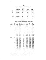
Figure I Generalized map of the Wilbur Mining ... - University of Utah
Figure I Generalized map of the Wilbur Mining ... - University of Utah
Figure I Generalized map of the Wilbur Mining ... - University of Utah

Create successful ePaper yourself
Turn your PDF publications into a flip-book with our unique Google optimized e-Paper software.
Geo<strong>the</strong>rmal Resources Council, TRAHSACTIOUS, Vol. 3 Septetiiber 1979<br />
BOREHOLE TEMPERATURE STUDIES OF<br />
THE LAS ALTURAS GEOTHERMAL ANOMALY, NEW MEXICO<br />
Paul Morgan, Chandler A. Swanberg<br />
and Richard L. Lohse<br />
New Mexico State <strong>University</strong><br />
Box 3D, Las Cruces, NM 88003<br />
ABSTRACT INTRODUCTION<br />
Three phases <strong>of</strong> borehole temperature studies<br />
have been made relative to <strong>the</strong> Las Alturas geo<strong>the</strong>rmal<br />
anomaly in sou<strong>the</strong>rn New Mexico: i) logging<br />
<strong>of</strong> "free" holes; ii) shallow gradient study; and<br />
ill) analysis <strong>of</strong> data from two 300m tests. A maximum<br />
temperature <strong>of</strong> 62.5''C (145°F) has been measured<br />
at 300m in one <strong>of</strong> <strong>the</strong> tests, and <strong>the</strong> data<br />
indicate that <strong>the</strong> source <strong>of</strong> <strong>the</strong> anomaly Is a hydro<strong>the</strong>rmal<br />
circulation system. A simple analysis<br />
<strong>of</strong> <strong>the</strong> temperature data indicate vertical water<br />
flow rates <strong>of</strong> <strong>the</strong> order <strong>of</strong> 1x10"^ m/s ('»' 1 ft/yr).<br />
The borehole temperature data have provided valuable<br />
information for delineating, evaluating and<br />
characterizing <strong>the</strong> nature <strong>of</strong> <strong>the</strong> source <strong>of</strong> <strong>the</strong><br />
jnomaly.<br />
NMSU SUBSURFACE TEMPERATURE<br />
RESEARCH STUDY<br />
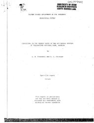
Geophysical, engineering and economic studies<br />
all indicate that <strong>the</strong> Las Alturas geo<strong>the</strong>rmal anomaly,<br />
located adjacent to <strong>the</strong> city <strong>of</strong> Las Cruces,<br />
New Mexico (<strong>Figure</strong> 1), is a potentially economic<br />
low temperature geo<strong>the</strong>rmai resource for direct<br />
heat applications at <strong>the</strong> New Mexico State <strong>University</strong><br />
campus (Gunaji et^ al.-, 1978; Dicey et al. ,<br />
this volume). Borehole temperature studies have<br />
been made in and around <strong>the</strong> Las Alturas anomaly in<br />
three phases: i) regional exploration comprising<br />
temperature measurements in "free" holes, 11) drilling<br />
and measurement <strong>of</strong> 30m temperature gradient<br />
» , .V I • -r--? ..'I-<br />
Flg. 1 Index <strong>map</strong> <strong>of</strong> that part <strong>of</strong> Las Cruces, New Mexico, which includes <strong>the</strong> New Mexico State <strong>University</strong><br />
campus (to <strong>the</strong> west) and <strong>the</strong> Las Alturas area (Wells, labeled 6-9). Also shown are <strong>the</strong> locations<br />
<strong>of</strong> <strong>the</strong> boreholes used for temperature studies.<br />
469