Figure I Generalized map of the Wilbur Mining ... - University of Utah
Figure I Generalized map of the Wilbur Mining ... - University of Utah
Figure I Generalized map of the Wilbur Mining ... - University of Utah

Create successful ePaper yourself
Turn your PDF publications into a flip-book with our unique Google optimized e-Paper software.
Geo<strong>the</strong>nnal Resources Council, TRANSACTIONS, Vol. 3 Septetrher 1979<br />
CONTINUOUS GRAVITY OBSERVATIONS AT THE GEYSERS:. A PRELIMINARY REPORT<br />
ABSTRACT<br />
A cryogenic gravimeter has been installed at<br />
The Geysers to continuously monitor gravity variations<br />
at <strong>the</strong> Mgal level. A 38-day record is presented<br />
to illustrate <strong>the</strong> type <strong>of</strong> information that<br />
can be obtained from such an instrument. In<br />
addition to information directly related to mass<br />
transport within <strong>the</strong> reservoir, <strong>the</strong> data reveal a<br />
sudden 6 ygal decrease in gravity prior to a local<br />
earthquake. We also observe a 5 ugal increase in<br />
gravity during a heavy rainfall; however, interpretation<br />
<strong>of</strong> gravity variations at this level is<br />
limited by uncertainty in tilting <strong>of</strong> <strong>the</strong> gravimeter<br />
pier. The potential Irapact <strong>of</strong> continuous<br />
gravity observations on <strong>the</strong> study <strong>of</strong> reservoir<br />
characteristics is discussed.<br />
THE CRYOGENIC GRAVIMETER<br />
Jeffrey J. Olson and Richard J. Warburton<br />
<strong>University</strong> <strong>of</strong> California at San Diego<br />
La Jolla CA 92093<br />
Although cryogenic gravimeters have been in<br />
existence for several years (Goodkind and Pro<strong>the</strong>ro^<br />
1968, and Warburton and Goodkind, 1978), this is<br />
<strong>the</strong> first use <strong>of</strong> such an instrument in a geo<strong>the</strong>rmal<br />
application. The instrument differs from conventional<br />
gravimeters in that mechanical springs<br />
and levers are replaced by magnetic fields generated<br />
from persistent currents in colls <strong>of</strong> superconducting<br />
wire. These fields support a one-inch •<br />
dlamecer superconducting sphere (<strong>the</strong> graviroeter's<br />
only moving part) with a force that does not<br />
significantly diminish in time, due to <strong>the</strong> persistence<br />
<strong>of</strong> superconducting currents. Thus <strong>the</strong><br />
cryogenic gravimeter does not exhibit <strong>the</strong> instrumentally<br />
produced signal drift which is characteristic<br />
<strong>of</strong> conventional gravimeters. Several years<br />
<strong>of</strong> gravity observations at Pinon Flat in sou<strong>the</strong>rn<br />
California indicate that <strong>the</strong> total Instrumental<br />
drift is 0 ± 5 ygal/yr. A planned side-by-side<br />
test <strong>of</strong> two cryogenic gravimeters at Pinon Flat<br />
should determine whe<strong>the</strong>r this residual variation<br />
is <strong>of</strong> instrumental or geophysical origin.<br />
The short term precision <strong>of</strong> <strong>the</strong> cryogenic<br />
gravimeter appears to be limited only by <strong>the</strong> uncertainty<br />
with which <strong>the</strong> contributions frora known<br />
sources such as earth and ocean tides and atmospheric<br />
density variations can be subtracted. The<br />
data presented below indicate that this can be<br />
accomplished empirically to a precision <strong>of</strong> ±1<br />
ligal. Spurious tilting <strong>of</strong> <strong>the</strong> gravimeter platform<br />
can degrade this performance, but tilt will soon<br />
be controlled by <strong>the</strong> addition <strong>of</strong> an automatic<br />
519<br />
leveling system.<br />
OBSERVATIONS AT THE GEYSERS<br />
A cryogenic gravimeter was installed in<br />
February <strong>of</strong> 1979 in The Geysers steam field at<br />
latitude 38° 48' 25" and longitude 122° 48' 50".<br />
This site is on a spur <strong>of</strong> ridge which extends<br />
downward from Well Sulphur Bank 19 toward Units 3<br />
and 4. McLaughlin (1974) <strong>map</strong>s this general area<br />
as a quaternary landslide, however, <strong>the</strong> spur<br />
appears to be an outcrop <strong>of</strong> relatively unfractured<br />
Franciscan graywacke. Wea<strong>the</strong>red graywacke<br />
slightly uphill <strong>of</strong> <strong>the</strong> outcrop was excavated to a<br />
depth <strong>of</strong> 2 - 3 m to expose bedrock, upon which a<br />
3 m high reinforced concrete pier was erected.<br />
The gravimeter platform rests on this pier, supported<br />
on three points two <strong>of</strong> which are heavy<br />
duty micrometer heads to allow alignraent <strong>of</strong> <strong>the</strong><br />
gravimeter with <strong>the</strong> vertical. The active element<br />
<strong>of</strong> <strong>the</strong> gravimeter is immersed in liquid helium in<br />
a Dewar which is fixed to <strong>the</strong> platform.<br />
The output signal from <strong>the</strong> gravimeter is in<br />
<strong>the</strong> form <strong>of</strong> an analog voltage which is filtered<br />
electronically for sampling at a variety <strong>of</strong> rates<br />
from 20 seconds to 15 minutes. Barometric<br />
pressure as measured by a temperature regulated<br />
aneroid barometer is also filtered and monitored<br />
at 15 minute intervals. These signals are recorded<br />
in <strong>the</strong> field on digital tape cassettes by a<br />
microcomputer-controlled data system, which can<br />
also transmit stored data by telephone to our laboratory<br />
for inspection.<br />
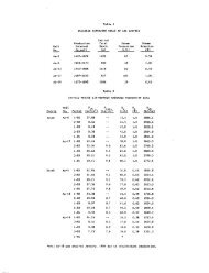
A sample <strong>of</strong> raw data toge<strong>the</strong>r with <strong>the</strong> results<br />
<strong>of</strong> various stages <strong>of</strong> its reductiori are shown<br />
in <strong>Figure</strong> 1. All four graphs are plotted as<br />
functions <strong>of</strong> time at 15 minute Intervals beginning<br />
at 067:00:00:00 UTC and ending 38 days later at<br />
105:00:00:00 UTC. The observed gravity signal,<br />
<strong>Figure</strong> la, is dominated by smooth tidal variations<br />
(<strong>the</strong> coarseness <strong>of</strong> this graph is an artifact <strong>of</strong><br />
<strong>the</strong> digital plotter: <strong>the</strong> point density is nearly<br />
1000 points per inch on this scale). The principal<br />
component <strong>of</strong> this signal is <strong>the</strong> direct gravitational<br />
attraction <strong>of</strong> <strong>the</strong> moon and sun toge<strong>the</strong>r<br />
with <strong>the</strong> effects <strong>of</strong> deformation <strong>of</strong> <strong>the</strong> earth's surface<br />
due to tidal forces and loading from ocean<br />
tides. These tidal effects contain little information<br />
relevant to <strong>the</strong> geo<strong>the</strong>rmal reservoir and<br />
must be removed before local effects can be observed.<br />
This can be accomplished by subtraction