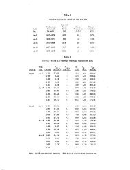
Figure I Generalized map of the Wilbur Mining ... - University of Utah
Figure I Generalized map of the Wilbur Mining ... - University of Utah
Figure I Generalized map of the Wilbur Mining ... - University of Utah

Create successful ePaper yourself
Turn your PDF publications into a flip-book with our unique Google optimized e-Paper software.
Geo<strong>the</strong>rmal Resources Counail, TRANSACTIONS Vol. 4, September 1980<br />
WATER GEOCHEMISTRY AT CASTLE HOT SPRINGS, ARIZONA<br />
Richard L. Satkln, Kenneth H. Wohletz and Michael F. Sheridan<br />
Department <strong>of</strong> Geology, Arizona State <strong>University</strong>, Tempe, Arizona 85281<br />
ABSTRACT<br />
A geochemical survey <strong>of</strong> springs and wells<br />
in <strong>the</strong> Castle Hot Springs area, Arizona, shows<br />
that three groups <strong>of</strong> waters can be distinguished<br />
by salinity and chemistry. The <strong>the</strong>rmal waters<br />
<strong>of</strong> Group I range from 640 to 820 ppm TDS, and<br />
<strong>the</strong> waters contain high concentrations <strong>of</strong> Si02,<br />
Li"*", and F~. The non-<strong>the</strong>rmal waters <strong>of</strong> Group<br />
II range from 380 to 580 ppm TDS and contain<br />
low concentrations <strong>of</strong> Si02, Li"*", and F~. The<br />
non-<strong>the</strong>rmal waters <strong>of</strong> Group III range from<br />
1600-1650 ppm TDS and contain <strong>the</strong> highest concentrations<br />
<strong>of</strong> Li+, Cl", and SO^^'^.<br />
The discrepancy between <strong>the</strong> low measured<br />
surface temperature at Castle Hot Springs, and<br />
<strong>the</strong> high temperatures estimated from chemical<br />
geo<strong>the</strong>rmometry suggest <strong>the</strong>rmal waters may have<br />
cooled ei<strong>the</strong>r hy conduction, boiling or mixing.<br />
TKe chalcedony mixing raodel yields a"^reservolr<br />
temperature <strong>of</strong> 95°C and a cold water fraction <strong>of</strong><br />
56%.<br />
INTRODUCTION<br />
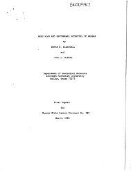
Castle Hot Springs ie located 70 km northwest<br />
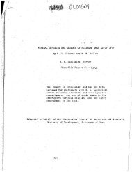
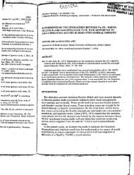
<strong>of</strong> Phoenix, Arizona (<strong>Figure</strong> 11. It is presently<br />
being evaluated for direct-use geo<strong>the</strong>rmal<br />
development <strong>of</strong> <strong>the</strong> resource for space heating and<br />
cooling. The results <strong>of</strong> hydrogeocKemtcal sampling<br />
<strong>of</strong> <strong>the</strong>rmal and non-<strong>the</strong>rmal springs and wells in<br />
<strong>the</strong> area are presented.<br />
GEOLOGIC SETTING<br />
The geologic setting <strong>of</strong> Castle Hot Springs<br />
has been discussed by Sheridan et al. (1979);. Recent<br />
detailed geologic <strong>map</strong>ping has documented a<br />
low-angle slump fault displacing an allochthonous<br />
block <strong>of</strong> Precambrian granite on top <strong>of</strong> a sequence<br />
<strong>of</strong> Tertiary volcanic rocks. The allochthonous<br />
block has been altered and is strongly brecciated<br />
and jointed resulting in increased permeability.<br />
Mixing <strong>of</strong> hydro<strong>the</strong>rmal fluids and cold meteoric<br />
water may be significant along this low-angle<br />
fault. Nielson and Moore (1979) have described a<br />
similar geologic situation at <strong>the</strong> Cove Fort-Sulphurdale<br />
geo<strong>the</strong>rmal system in <strong>Utah</strong>. They suggest<br />
that <strong>the</strong> allochthonous rocks may serve as a <strong>the</strong>rmal<br />
cap on <strong>the</strong> system separating a convective <strong>the</strong>r-<br />
177<br />
mal regime beneath <strong>the</strong> low-angle fault from a<br />
zone <strong>of</strong> conductive heat transport and probable<br />
fresh water influx above <strong>the</strong> principal fault<br />
zone.<br />
Calif<strong>of</strong>nie<br />
<strong>Figure</strong> 1.<br />
Mexico<br />
<strong>Utah</strong><br />
•* Cjstle Hot Sprirgs<br />
• PhoeniK<br />
"""^-^ 0<br />
""-^.^<br />
100 Km<br />
_<br />
Colorado<br />
New<br />
Mexico<br />
Location <strong>map</strong> <strong>of</strong> Castle Hot Springs,<br />
Arizona.<br />
HYDROLOGIC SETTING<br />
The <strong>the</strong>rmal waters <strong>of</strong> Group I display similar<br />
physical and cheraical characteristics. The<br />
waters <strong>of</strong> Group I are: Castle Hot Springs, Alkalai<br />
Spring, Henderson Ranch Spring and <strong>the</strong> Dodd<br />
Well. The <strong>the</strong>rmal waters occur along a 0.8 km<br />
alignment trending N.45°W. which coincides with<br />
<strong>the</strong> trend <strong>of</strong> a major fault system bounding Precambrian<br />
crystalline rocks and Tertiary volcanic<br />
rocks. The <strong>the</strong>rmal springs all emanate at an elevation<br />
<strong>of</strong> 658 meters along <strong>the</strong> same fault system<br />
suggesting an apparent hydrostatic relationship.<br />
The <strong>the</strong>rmal waters display a homogenous chemistry<br />
which indicates <strong>the</strong>y probably originate from <strong>the</strong><br />
same geo<strong>the</strong>rmal reservoir.<br />
WATER SAMPLING AND ANALYTICAL PROCEDURE<br />
An important aspect <strong>of</strong> this investigation is