The Economic Value of Water and Ecosystem Preservation
The Economic Value of Water and Ecosystem Preservation
The Economic Value of Water and Ecosystem Preservation

Create successful ePaper yourself
Turn your PDF publications into a flip-book with our unique Google optimized e-Paper software.
1. Overview <strong>of</strong> San Antonio Bay Region<br />
1.1. Geographic Setting for the San Antonio Bay Region<br />
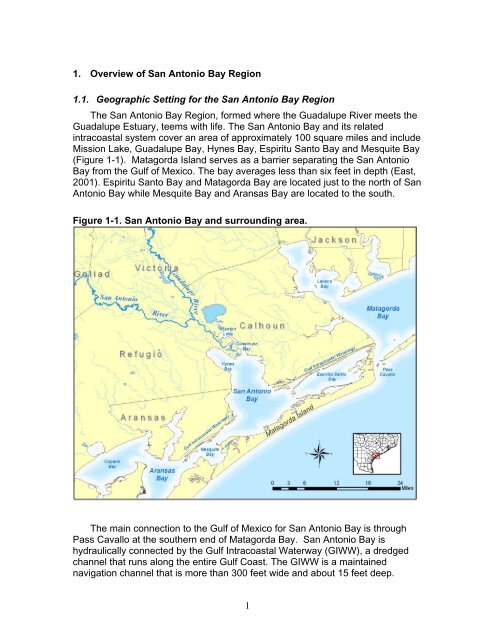
<strong>The</strong> San Antonio Bay Region, formed where the Guadalupe River meets the<br />
Guadalupe Estuary, teems with life. <strong>The</strong> San Antonio Bay <strong>and</strong> its related<br />
intracoastal system cover an area <strong>of</strong> approximately 100 square miles <strong>and</strong> include<br />
Mission Lake, Guadalupe Bay, Hynes Bay, Espiritu Santo Bay <strong>and</strong> Mesquite Bay<br />
(Figure 1-1). Matagorda Isl<strong>and</strong> serves as a barrier separating the San Antonio<br />
Bay from the Gulf <strong>of</strong> Mexico. <strong>The</strong> bay averages less than six feet in depth (East,<br />
2001). Espiritu Santo Bay <strong>and</strong> Matagorda Bay are located just to the north <strong>of</strong> San<br />
Antonio Bay while Mesquite Bay <strong>and</strong> Aransas Bay are located to the south.<br />
Figure 1-1. San Antonio Bay <strong>and</strong> surrounding area.<br />
<strong>The</strong> main connection to the Gulf <strong>of</strong> Mexico for San Antonio Bay is through<br />
Pass Cavallo at the southern end <strong>of</strong> Matagorda Bay. San Antonio Bay is<br />
hydraulically connected by the Gulf Intracoastal <strong>Water</strong>way (GIWW), a dredged<br />
channel that runs along the entire Gulf Coast. <strong>The</strong> GIWW is a maintained<br />
navigation channel that is more than 300 feet wide <strong>and</strong> about 15 feet deep.<br />
1