Report - Oregon State Library: State Employee Information Center ...
Report - Oregon State Library: State Employee Information Center ...
Report - Oregon State Library: State Employee Information Center ...

Create successful ePaper yourself
Turn your PDF publications into a flip-book with our unique Google optimized e-Paper software.
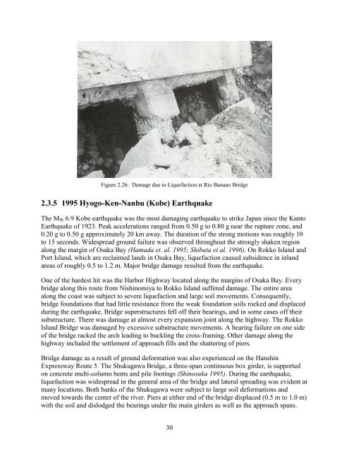
Figure 2.26: Damage due to Liquefaction at Rio Banano Bridge<br />
2.3.5 1995 Hyogo-Ken-Nanbu (Kobe) Earthquake<br />
The M W 6.9 Kobe earthquake was the most damaging earthquake to strike Japan since the Kanto<br />
Earthquake of 1923. Peak accelerations ranged from 0.50 g to 0.80 g near the rupture zone, and<br />
0.20 g to 0.50 g approximately 20 km away. The duration of the strong motions was roughly 10<br />
to 15 seconds. Widespread ground failure was observed throughout the strongly shaken region<br />
along the margin of Osaka Bay (Hamada et. al. 1995; Shibata et al. 1996). On Rokko Island and<br />
Port Island, which are reclaimed lands in Osaka Bay, liquefaction caused subsidence in inland<br />
areas of roughly 0.5 to 1.2 m. Major bridge damage resulted from the earthquake.<br />
One of the hardest hit was the Harbor Highway located along the margins of Osaka Bay. Every<br />
bridge along this route from Nishinomiya to Rokko Island suffered damage. The entire area<br />
along the coast was subject to severe liquefaction and large soil movements. Consequently,<br />
bridge foundations that had little resistance from the weak foundation soils rocked and displaced<br />
during the earthquake. Bridge superstructures fell off their bearings, and in some cases off their<br />
substructure. There was damage at almost every expansion joint along the highway. The Rokko<br />
Island Bridge was damaged by excessive substructure movements. A bearing failure on one side<br />
of the bridge racked the arch leading to buckling the cross-framing. Other damage along the<br />
highway included the settlement of approach fills and the shattering of piers.<br />
Bridge damage as a result of ground deformation was also experienced on the Hanshin<br />
Expressway Route 5. The Shukugawa Bridge, a three-span continuous box girder, is supported<br />
on concrete multi-column bents and pile footings (Shinosuka 1995). During the earthquake,<br />
liquefaction was widespread in the general area of the bridge and lateral spreading was evident at<br />
many locations. Both banks of the Shukugawa were subject to large soil deformations and<br />
moved towards the center of the river. Piers at either end of the bridge displaced (0.5 m to 1.0 m)<br />
with the soil and dislodged the bearings under the main girders as well as the approach spans.<br />
30