

A Natural Resource Management Guide for the County of Morris A ...
A Natural Resource Management Guide for the County of Morris A ...
A Natural Resource Management Guide for the County of Morris A ...

Create successful ePaper yourself
Turn your PDF publications into a flip-book with our unique Google optimized e-Paper software.
o<br />
z<br />
o<br />
P<br />
a<br />
le<br />
Late<br />
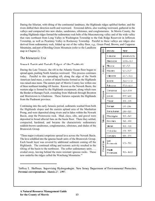
570 - 900<br />
Proterozoic<br />
Middle<br />
900 - 1600<br />
Proterozoic<br />
During <strong>the</strong> Silurian, with tilting <strong>of</strong> <strong>the</strong> continental landmass, <strong>the</strong> Highlands ridges uplifted fur<strong>the</strong>r, and <strong>the</strong><br />
rivers shifted <strong>the</strong>ir direction north and westward. Erosional debris, also washing westward, ga<strong>the</strong>red in <strong>the</strong><br />
valleys and compacted into new shales, sandstones, siltstones, and conglomerates. In <strong>Morris</strong> <strong>County</strong>, <strong>the</strong><br />
eroding Highlands ridges <strong>for</strong>med <strong>the</strong> sedimentary rock belts <strong>of</strong> <strong>the</strong> Musconetcong valley and <strong>of</strong> <strong>the</strong> wide valley<br />
that runs nor<strong>the</strong>ast from Long Valley in Washington Township to <strong>the</strong> Oak Ridge Reservoir in Jefferson<br />
Township, as well as Picatinny Valley in Rockaway Township. Parallel to <strong>the</strong>se valleys are ridges also<br />
derived from sedimentary rock, folded up out <strong>of</strong> <strong>the</strong> valley floor, e.g., Green Pond, Brown, and Copperas<br />
Mountains, and part <strong>of</strong> Bowling Green Mountain (refer to <strong>the</strong> Land<strong>for</strong>m<br />
A<br />
map in Chapter 2).<br />
E<br />
R<br />
EPOCH<br />
TIME<br />
Holocene<br />
present-0.016<br />
The Mesozoic Era<br />
Pleistocene 0.016 - 1.0<br />
Newark Basin and Basalt Ridges <strong>of</strong> <strong>the</strong> Piedmont<br />
During <strong>the</strong> Late Triassic, <strong>the</strong> rift in <strong>the</strong> Atlantic Ocean floor began to<br />
spread again, pushing North America westward. This process continues<br />
today. Parallel to this spreading rift, along <strong>the</strong> edge <strong>of</strong> <strong>the</strong> North<br />
American land mass, a series <strong>of</strong> inland basins <strong>for</strong>med as <strong>the</strong> Highlands<br />
was raised once more. The eastern part <strong>of</strong> <strong>Morris</strong> <strong>County</strong> lies within one<br />
<strong>of</strong> <strong>the</strong>se nor<strong>the</strong>ast trending rift basins. Known as <strong>the</strong> Newark Basin, <strong>the</strong><br />
western edge is <strong>for</strong>med by <strong>the</strong> Highlands escarpment, along which runs<br />
<strong>the</strong> Border or Ramapo Fault, extending from Mahwah through Boonton<br />
and <strong>Morris</strong>town to Gladstone. These features separate <strong>the</strong> Highlands<br />
from <strong>the</strong> Piedmont province.<br />
o<br />
z<br />
o<br />
n<br />
C<br />
e<br />
ic<br />
o<br />
z<br />
o<br />
s<br />
M<br />
e<br />
1.0 - 5.3<br />
Pliocene<br />
5.3 - 23.7<br />
Miocene<br />
23.7 - 36.6<br />
Oligocene<br />
36.6 - 57.8<br />
Eocene<br />
57.8 - 66.4<br />
Paleocene<br />
66.4 - 144<br />
Cretaceous<br />
144 - 208<br />
Jurassic<br />
ic<br />
Continuing into <strong>the</strong> early Jurassic period, sediments washed from both<br />
<strong>the</strong> Highlands slopes and <strong>the</strong> eastern upland area <strong>of</strong> <strong>the</strong> Manhattan<br />
Prong, and were deposited along rivers and in lakes within <strong>the</strong> Newark<br />
Basin, atop <strong>the</strong> Proterozoic rock. Mud, clays, silts, and gravel were<br />
deposited in broad alluvial fans on <strong>the</strong> basin floor. There <strong>the</strong>y settled,<br />
compacted, hardened, and became <strong>the</strong> characteristic sedimentary<br />
reddish-brown sandstones, conglomerates, siltstones, and shales <strong>of</strong> <strong>the</strong><br />
Brunswick Group.<br />
ic<br />
208 - 245<br />
Triassic<br />
245 -286<br />
Permian<br />
286 - 320<br />
Pennsylvanian<br />
320 - 360<br />
Mississippian<br />
360 - 408<br />
Devonian<br />
408 - 438<br />
Silurian<br />
"Three major (volcanic) eruptions spread lava across <strong>the</strong> Newark Basin.<br />
The lava solidified into <strong>the</strong> igneous basalt units <strong>of</strong> <strong>the</strong> Brunswick Group.<br />
Each basalt layer was covered by additional sediment coming <strong>of</strong>f <strong>the</strong><br />
Highlands. The continual rifting and tectonic activity resulted in <strong>the</strong><br />
tilting <strong>of</strong> <strong>the</strong> basin to <strong>the</strong> northwest. The s<strong>of</strong>ter sedimentary units . . .<br />
eroded away, leaving behind <strong>the</strong> more resistant igneous rocks. These<br />
now underlie <strong>the</strong> ridges called <strong>the</strong> Watchung Mountains." 1<br />
n<br />
ia<br />
r<br />
m<br />
b<br />
a<br />
c<br />
P<br />
r<br />
e<br />
Cambrian 505 - 570<br />
Ordovician 438 - 505<br />
1<br />
,GHHTG[.*QHHOCP5WRGTXKUKPI*[FTQIGQNQIKUV0GY,GTUG[&GRCTVOGPVQH'PXKTQPOGPVCN2TQVGEVKQP<br />
2GTUQPCNEQTTGURQPFGPEG/CTEJ<br />
A <strong>Natural</strong> <strong>Resource</strong> <strong>Management</strong> <strong>Guide</strong><br />
<strong>for</strong> <strong>the</strong> <strong>County</strong> <strong>of</strong> <strong>Morris</strong> 13