65th IHC Booklet/Program (pdf - 4.9MB) - Office of the Federal ...
65th IHC Booklet/Program (pdf - 4.9MB) - Office of the Federal ...
65th IHC Booklet/Program (pdf - 4.9MB) - Office of the Federal ...
You also want an ePaper? Increase the reach of your titles
YUMPU automatically turns print PDFs into web optimized ePapers that Google loves.
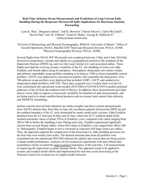
Real-Time Airborne Ocean Measurements and Predictions <strong>of</strong> Loop Current Eddy<br />
Shedding During <strong>the</strong> Deepwater Horizon Oil Spill: Implications for Hurricane Intensity<br />
Forecasting<br />
Lynn K. Shay 1 , Benjamin Jaimes 1 , Jodi K. Brewster 1 , Patrick Meyers 1 , Claire McCaskill 1 ,<br />
Steven Paul 2 , Eric W. Uhlhorn 3 , Frank D. Marks 3 , George R. Halliwell Jr. 4<br />
(nshay@rsmas.miami.edu)<br />
1 Division <strong>of</strong> Meteorology and Physical Oceanography, RSMAS, University <strong>of</strong> Miami; 2 <strong>Office</strong> <strong>of</strong><br />
Aircraft Operations, NOAA, MacDill AFB 3 Hurricane Research Division, NOAA, AOML<br />
4 Physical Oceanography Division, NOAA, AOML<br />
Several flights from NOAA WP-3D aircraft were conducted between 5 May and 9 July 2010 that<br />
focused on temperature, currents and salinity in a geographical location to <strong>the</strong> sou<strong>the</strong>ast <strong>of</strong> <strong>the</strong><br />
Deepwater Horizon (DWH) rig, and over <strong>the</strong> Loop Current (LC) and associated eddies. These<br />
flights provided <strong>the</strong> evolving oceanic variability <strong>of</strong> <strong>the</strong> LC, <strong>the</strong> shedding <strong>of</strong> warm core eddy<br />
Franklin, and frontal eddies along its' periphery. Atmospheric dropsondes (for surface winds)<br />
and airborne expendable ocean pr<strong>of</strong>ilers sampling to as deep as 1500 m (from expendable current<br />
pr<strong>of</strong>ilers: AXCP) were deployed in a lawnmower pattern with essentially <strong>the</strong> drop points. Over<br />
700 airborne ocean pr<strong>of</strong>ilers were deployed that included AXBT, AXCP, and conductivitytemperature-depth<br />
pr<strong>of</strong>ilers (AXCTD). These data, acquired over a weekly basis over <strong>the</strong> LC,<br />
were assimilated into operational ocean models (HYCOM) at NAVOCEANO to predict potential<br />
pathways <strong>of</strong> <strong>the</strong> oil from <strong>the</strong> nor<strong>the</strong>rn Gulf <strong>of</strong> Mexico. In addition, <strong>the</strong>se measurements provided<br />
data to vector ships to regions <strong>of</strong> mesoscale variability for detailed oil spill measurements, and<br />
are being used to evaluate satellite-based products such as oceanic heat content from altimetry<br />
and SMARTS climatology.<br />
Surface currents derived from altimeter sea surface heights and direct current measurements<br />
from AXCPs indicate that, from May to June, <strong>the</strong> circulation patterns between <strong>the</strong> DWH rig and<br />
<strong>the</strong> nor<strong>the</strong>rn boundary <strong>of</strong> <strong>the</strong> LC were dominated by nearly small-scale cyclones. Eddy Franklin<br />
detached from <strong>the</strong> LC between 28 May and 18 June, where <strong>the</strong> 20 o C iso<strong>the</strong>rm depth (h20)<br />
reached maximum values <strong>of</strong> about 320 m at Franklin’s core, compared with values ranging from<br />
280 to 300 m before <strong>the</strong> shedding event. During early July, Franklin experienced significant<br />
erosion from several frontal eddies, where h20 values in Franklin’s core ranged from 260 to 280<br />
m. Subsequently, Franklin began to move westward as expected with large warm core eddies.<br />
Thus, <strong>the</strong> approach captured <strong>the</strong> complexities <strong>of</strong> <strong>the</strong> mesoscale LC-eddy shedding processes for<br />
<strong>the</strong> first time over weekly time scales. The <strong>the</strong>rmal structure data from all pr<strong>of</strong>ilers were<br />
assimilated into <strong>the</strong> operational HYCOM whereas <strong>the</strong> salinity and current data are being used to<br />
evaluate model performance. Analyses <strong>of</strong> twin numerical experiments with and without data<br />
assimilation clearly revealed <strong>the</strong> unprecedented importance <strong>of</strong> <strong>the</strong> real-time, 3-D measurements<br />
in improving <strong>the</strong> trajectories to guide cleanup efforts. This approach needs to be applied to<br />
oceanic and coupled model efforts and implemented for real-time ocean forecasting at <strong>the</strong><br />
National Centers for eventual use in coupled model forecasts.<br />
Session 4 – Page 1


