65th IHC Booklet/Program (pdf - 4.9MB) - Office of the Federal ...
65th IHC Booklet/Program (pdf - 4.9MB) - Office of the Federal ...
65th IHC Booklet/Program (pdf - 4.9MB) - Office of the Federal ...
Create successful ePaper yourself
Turn your PDF publications into a flip-book with our unique Google optimized e-Paper software.
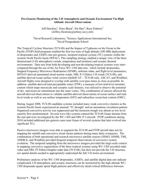
Pre-Genesis Monitoring <strong>of</strong> <strong>the</strong> 3-D Atmospheric and Oceanic Environment Via High<br />
Altitude Aircraft Observations<br />
Jeff Hawkins 1 , Peter Black 2 , Pat Harr 3 , Russ Elsberry 3<br />
(Jeffrey.Hawkins@nrlmry.navy.mil)<br />
1 Naval Research Laboratory; 2 Science Applications International Inc;<br />
3 Naval Postgraduate School<br />
The Tropical Cyclone Structure (TCS-08) and <strong>the</strong> Impact <strong>of</strong> Typhoons on <strong>the</strong> Ocean in <strong>the</strong><br />
Pacific (ITOP) field programs enabled <strong>the</strong> first two tests <strong>of</strong> high altitude (300 MB) deployment<br />
<strong>of</strong> dropsondes and AXBTs into pre-genesis, incipient tropical cyclone (TC) systems within <strong>the</strong><br />
western North Pacific basin (WPAC). This sampling strategy enabled a unique view <strong>of</strong> <strong>the</strong> three<br />
dimensional (3-D) atmospheric (winds, temperature and moisture) and oceanic <strong>the</strong>rmal<br />
environments. Data sets from both developing and non-developing tropical systems were intercompared<br />
through <strong>the</strong> use <strong>of</strong> <strong>the</strong> Air Force WC-130J data sets, which include dropsondes,<br />
Stepped Frequency Microwave Radiometer (SFMR), airborne radar, and flight level parameters,<br />
MTSAT-derived automated cloud motion winds, NRL P-3 Eldora 3-D winds (TCS-08), and<br />
satellite-derived ocean surface wind vectors (QuikSCAT – TCS-08 only, ASCAT, and WindSat).<br />
Aircraft flights were designed to overlap with satellite over-pass times as close as possible. In<br />
addition, satellite-derived total precipitable water (TPW), a measure <strong>of</strong> low/mid-level moisture<br />
content which maps mesoscale and synoptic scale features, was utilized to observe <strong>the</strong> potential<br />
<strong>of</strong> dry- and moist-air entrainment into <strong>the</strong> inner vortex. This combination <strong>of</strong> sensors allowed <strong>the</strong><br />
aircraft-derived observations to validate satellite-derived observations <strong>of</strong> ocean surface and midlevel<br />
winds as well as sea surface temperature (SST) and subsurface ocean heat content (OHC).<br />
During August 2008, TCS-08 candidate systems included many weak convective clusters as <strong>the</strong><br />
western Pacific basin experienced an unusual ‘TC drought’ and an anomalous circulation pattern.<br />
Organized convective activity was suppressed and <strong>the</strong> monsoon trough was absent as low-level<br />
easterly flow predominated. Several wave-like systems entered <strong>the</strong> TCS-08 Guam domain from<br />
<strong>the</strong> east and were investigated by <strong>the</strong> WC-130J and NRL P-3 aircraft. ITOP conditions during<br />
2010 included additional pre-genesis cases near Guam <strong>of</strong> several systems that later evolved into<br />
significant TCs.<br />
Passive microwave imagers were able to augment <strong>the</strong> TCS-08 and ITOP aircraft data sets by<br />
mapping <strong>the</strong> rainfall and convective cloud cluster patterns during many daily overpasses. The<br />
combination <strong>of</strong> both operational and research microwave satellite sensors (SSM/I, SSMIS, TMI,<br />
AMSR-E, and WindSat) provided frequent temporal observations <strong>of</strong> convective system<br />
evolution. The temporal sampling from <strong>the</strong> microwave imagers provided <strong>the</strong> large-scale context<br />
in mapping convective organization <strong>of</strong> <strong>the</strong> three tropical systems using WC-130J recorded radar<br />
video and NRL P3 Eldora Doppler radar data (TCS-08), but does not provide <strong>the</strong> 3-D structure,<br />
nor spatial details needed to appropriately understand <strong>the</strong> full 3-D storm environment.<br />
Preliminary analysis <strong>of</strong> <strong>the</strong> WC-130J dropsondes, AXBTs, and satellite digital data sets indicate<br />
complicated 3-D atmospheric and oceanic structures can be monitored by <strong>the</strong> high altitude WC-<br />
130J dropsonde square spiral flight patterns and effectively detail critical differences between<br />
Session 9 – Page 4


