65th IHC Booklet/Program (pdf - 4.9MB) - Office of the Federal ...
65th IHC Booklet/Program (pdf - 4.9MB) - Office of the Federal ...
65th IHC Booklet/Program (pdf - 4.9MB) - Office of the Federal ...
Create successful ePaper yourself
Turn your PDF publications into a flip-book with our unique Google optimized e-Paper software.
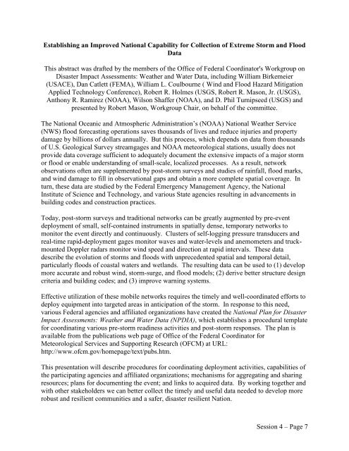
Establishing an Improved National Capability for Collection <strong>of</strong> Extreme Storm and Flood<br />
Data<br />
This abstract was drafted by <strong>the</strong> members <strong>of</strong> <strong>the</strong> <strong>Office</strong> <strong>of</strong> <strong>Federal</strong> Coordinator's Workgroup on<br />
Disaster Impact Assessments: Wea<strong>the</strong>r and Water Data, including William Birkemeier<br />
(USACE), Dan Catlett (FEMA), William L. Coulbourne ( Wind and Flood Hazard Mitigation<br />
Applied Technology Conference), Robert R. Holmes (USGS, Robert R. Mason, Jr. (USGS),<br />
Anthony R. Ramirez (NOAA), Wilson Shaffer (NOAA), and D. Phil Turnipseed (USGS) and<br />
presented by Robert Mason, Workgroup Chair, on behalf <strong>of</strong> <strong>the</strong> committee.<br />
The National Oceanic and Atmospheric Administration’s (NOAA) National Wea<strong>the</strong>r Service<br />
(NWS) flood forecasting operations saves thousands <strong>of</strong> lives and reduce injuries and property<br />
damage by billions <strong>of</strong> dollars annually. But this process, which depends on data from thousands<br />
<strong>of</strong> U.S. Geological Survey streamgages and NOAA meteorological stations, usually does not<br />
provide data coverage sufficient to adequately document <strong>the</strong> extensive impacts <strong>of</strong> a major storm<br />
or flood or enable understanding <strong>of</strong> small-scale, localized processes. As a result, network<br />
observations <strong>of</strong>ten are supplemented by post-storm surveys and studies <strong>of</strong> rainfall, flood marks,<br />
and wind damage to fill in observational gaps and obtain a more complete spatial coverage. In<br />
turn, <strong>the</strong>se data are studied by <strong>the</strong> <strong>Federal</strong> Emergency Management Agency, <strong>the</strong> National<br />
Institute <strong>of</strong> Science and Technology, and various State agencies resulting in advancements in<br />
building codes and construction practices.<br />
Today, post-storm surveys and traditional networks can be greatly augmented by pre-event<br />
deployment <strong>of</strong> small, self-contained instruments in spatially dense, temporary networks to<br />
monitor <strong>the</strong> event directly and continuously. Clusters <strong>of</strong> self-logging pressure transducers and<br />
real-time rapid-deployment gages monitor waves and water-levels and anemometers and truckmounted<br />
Doppler radars monitor wind speed and direction at rapid intervals. These data<br />
describe <strong>the</strong> evolution <strong>of</strong> storms and floods with unprecedented spatial and temporal detail,<br />
particularly floods <strong>of</strong> coastal waters and wetlands. The resulting data can be used to (1) develop<br />
more accurate and robust wind, storm-surge, and flood models; (2) derive better structure design<br />
criteria and building codes; and (3) improve warning systems.<br />
Effective utilization <strong>of</strong> <strong>the</strong>se mobile networks requires <strong>the</strong> timely and well-coordinated efforts to<br />
deploy equipment into targeted areas in anticipation <strong>of</strong> <strong>the</strong> storm. In response to this need,<br />
various <strong>Federal</strong> agencies and affiliated organizations have created <strong>the</strong> National Plan for Disaster<br />
Impact Assessments: Wea<strong>the</strong>r and Water Data (NPDIA), which establishes a procedural template<br />
for coordinating various pre-storm readiness activities and post-storm responses. The plan is<br />
available from <strong>the</strong> publications web page <strong>of</strong> <strong>Office</strong> <strong>of</strong> <strong>the</strong> <strong>Federal</strong> Coordinator for<br />
Meteorological Services and Supporting Research (OFCM) at URL:<br />
http://www.<strong>of</strong>cm.gov/homepage/text/pubs.htm.<br />
This presentation will describe procedures for coordinating deployment activities, capabilities <strong>of</strong><br />
<strong>the</strong> participating agencies and affiliated organizations; mechanisms for aggregating and sharing<br />
resources; plans for documenting <strong>the</strong> event; and links to acquired data. By working toge<strong>the</strong>r and<br />
with o<strong>the</strong>r stakeholders we can better collect <strong>the</strong> timely and useful data needed to develop more<br />
robust and resilient communities and a safer, disaster resilient Nation.<br />
Session 4 – Page 7


