65th IHC Booklet/Program (pdf - 4.9MB) - Office of the Federal ...
65th IHC Booklet/Program (pdf - 4.9MB) - Office of the Federal ...
65th IHC Booklet/Program (pdf - 4.9MB) - Office of the Federal ...
You also want an ePaper? Increase the reach of your titles
YUMPU automatically turns print PDFs into web optimized ePapers that Google loves.
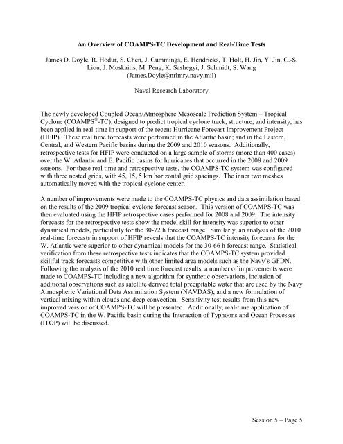
An Overview <strong>of</strong> COAMPS-TC Development and Real-Time Tests<br />
James D. Doyle, R. Hodur, S. Chen, J. Cummings, E. Hendricks, T. Holt, H. Jin, Y. Jin, C.-S.<br />
Liou, J. Moskaitis, M. Peng, K. Sashegyi, J. Schmidt, S. Wang<br />
(James.Doyle@nrlmry.navy.mil)<br />
Naval Research Laboratory<br />
The newly developed Coupled Ocean/Atmosphere Mesoscale Prediction System – Tropical<br />
Cyclone (COAMPS ® -TC), designed to predict tropical cyclone track, structure, and intensity, has<br />
been applied in real-time in support <strong>of</strong> <strong>the</strong> recent Hurricane Forecast Improvement Project<br />
(HFIP). These real time forecasts were performed in <strong>the</strong> Atlantic basin; and in <strong>the</strong> Eastern,<br />
Central, and Western Pacific basins during <strong>the</strong> 2009 and 2010 seasons. Additionally,<br />
retrospective tests for HFIP were conducted on a large sample <strong>of</strong> storms (more than 400 cases)<br />
over <strong>the</strong> W. Atlantic and E. Pacific basins for hurricanes that occurred in <strong>the</strong> 2008 and 2009<br />
seasons. For <strong>the</strong>se real time and retrospective tests, <strong>the</strong> COAMPS-TC system was configured<br />
with three nested grids, with 45, 15, 5 km horizontal grid spacings. The inner two meshes<br />
automatically moved with <strong>the</strong> tropical cyclone center.<br />
A number <strong>of</strong> improvements were made to <strong>the</strong> COAMPS-TC physics and data assimilation based<br />
on <strong>the</strong> results <strong>of</strong> <strong>the</strong> 2009 tropical cyclone forecast season. This version <strong>of</strong> COAMPS-TC was<br />
<strong>the</strong>n evaluated using <strong>the</strong> HFIP retrospective cases performed for 2008 and 2009. The intensity<br />
forecasts for <strong>the</strong> retrospective tests show <strong>the</strong> model skill for intensity was superior to o<strong>the</strong>r<br />
dynamical models, particularly for <strong>the</strong> 30-72 h forecast range. Similarly, an analysis <strong>of</strong> <strong>the</strong> 2010<br />
real-time forecasts in support <strong>of</strong> HFIP reveals that <strong>the</strong> COAMPS-TC intensity forecasts for <strong>the</strong><br />
W. Atlantic were superior to o<strong>the</strong>r dynamical models for <strong>the</strong> 30-66 h forecast range. Statistical<br />
verification from <strong>the</strong>se retrospective tests indicates that <strong>the</strong> COAMPS-TC system provided<br />
skillful track forecasts competitive with o<strong>the</strong>r limited area models such as <strong>the</strong> Navy’s GFDN.<br />
Following <strong>the</strong> analysis <strong>of</strong> <strong>the</strong> 2010 real time forecast results, a number <strong>of</strong> improvements were<br />
made to COAMPS-TC including a new algorithm for syn<strong>the</strong>tic observations, inclusion <strong>of</strong><br />
additional observations such as satellite derived total precipitable water that are used by <strong>the</strong> Navy<br />
Atmospheric Variational Data Assimilation System (NAVDAS), and a new formulation <strong>of</strong><br />
vertical mixing within clouds and deep convection. Sensitivity test results from this new<br />
improved version <strong>of</strong> COAMPS-TC will be presented. Additionally, real-time application <strong>of</strong><br />
COAMPS-TC in <strong>the</strong> W. Pacific basin during <strong>the</strong> Interaction <strong>of</strong> Typhoons and Ocean Processes<br />
(ITOP) will be discussed.<br />
Session 5 – Page 5


