Europes ecological backbone.pdf
Europes ecological backbone.pdf
Europes ecological backbone.pdf

You also want an ePaper? Increase the reach of your titles
YUMPU automatically turns print PDFs into web optimized ePapers that Google loves.
Protected areas<br />
Box 9.3 Land use development and nature conservation problems in Slovak biosphere reserves<br />
The aim of biosphere reserves (BRs) within UNESCO's Man and Biosphere programme is to reconcile<br />
biodiversity conservation, economic and social development and local cultural values through the<br />
sustainable use of landscapes and their resources (UNESCO, 2008). There are four BRs in Slovakia, all in<br />
mountain areas: Poľana; Tatry and Slovak Karst (both bilateral BRs, with Poland and Hungary respectively);<br />
and East Carpathians (a trilateral BR with Poland and Ukraine). The Slovak Karst and Tatry BRs extend from<br />
basin slopes up to karst plateaus (Slovak Karst) or periglacial high mountain landscapes (Tatry). Though<br />
their natural assets are different, their land-use development has been quite similar. The adjacent basins,<br />
settled in prehistoric and medieval times, were used mainly for crop production and grazing that strongly<br />
affected nearby forests. The areas of the Poľana and the East Carpathians BRs were colonised in the late<br />
16th to 17th centuries, influencing the traditional land use, with smaller villages in narrow valleys with<br />
numerous forest pastures and subsistence based mainly on sheep and cattle grazing.<br />
Until the first half of the 20th century, land use in all four BRs was quite stable and similar, based mainly<br />
on agriculture and forestry. Subsequently, urbanisation, agricultural collectivisation, and the development<br />
of industry and transport were predominantly in more suitable lowlands or basins where land use<br />
intensification prevailed. In higher and remote locations, extensification took place (Olah et al., 2006). The<br />
few exceptions were in areas where land use was affected by new socioeconomic phenomena, such as the<br />
development of tourism centres in the Tatry BR, and the construction of dams and forced emigration in<br />
the East Carpathians BR (Map 9.2). The end of the 20th century and the first decade of this century were<br />
characterised by the rapid acceleration of land-use changes mainly because of socioeconomic changes, but<br />
also because of more frequent climate events.<br />
Land use extensification, or even total abandonment, of these agricultural landscapes results from<br />
unprofitable management and changing social preferences. Most mountain grasslands are secondary<br />
vegetation formations whose continuity demands a certain amount of subsidiary energy through human<br />
activities. The economic regression of the 1990s, combined with negative demographic trends — emigration<br />
to larger towns and the rupture of peasants' links to their land due to 40 years of collectivised property<br />
— has led to land abandonment and secondary succession. Between 1949 and 2003, two-thirds of the<br />
grasslands in Poľana BR were overgrown (Gallayová, 2008). This natural process can lead to the loss of<br />
specialised species whose existence depends on specific management practices, as in the East Carpathians<br />
(Ružičková et al., 2001). Decreases in biodiversity not only mean that the objectives of Natura 2000 are not<br />
achieved, but also cause significant loss of cultural landscapes, their scenery and traditional character (Olah<br />
and Boltižiar, 2009), especially in such extensively used sub-mountain and mountain cultural landscapes<br />
with HNV farmland. Land use intensification — either more intense management (forest monocultures<br />
or clearcutting) or urbanisation — also significantly alters or even completely destroys natural assets in<br />
protected areas. While forestry intensification affects almost all Slovak mountain BRs, the development of<br />
tourism centres and sport infrastructure mainly affects Tatry BR.<br />
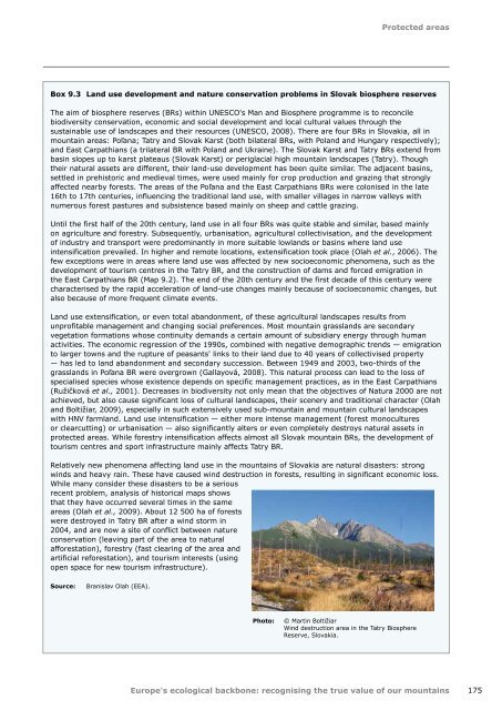
Relatively new phenomena affecting land use in the mountains of Slovakia are natural disasters: strong<br />
winds and heavy rain. These have caused wind destruction in forests, resulting in significant economic loss.<br />
While many consider these disasters to be a serious<br />
recent problem, analysis of historical maps shows<br />
that they have occurred several times in the same<br />
areas (Olah et al., 2009). About 12 500 ha of forests<br />
were destroyed in Tatry BR after a wind storm in<br />
2004, and are now a site of conflict between nature<br />
conservation (leaving part of the area to natural<br />
afforestation), forestry (fast clearing of the area and<br />
artificial reforestation), and tourism interests (using<br />
open space for new tourism infrastructure).<br />
Source:<br />
Branislav Olah (EEA).<br />
Photo:<br />
© Martin Boltižiar<br />
Wind destruction area in the Tatry Biosphere<br />
Reserve, Slovakia.<br />
Europe's <strong>ecological</strong> <strong>backbone</strong>: recognising the true value of our mountains<br />
175