Regional Land Transport Programme 2009 - 2010 (2MB) - Auckland ...
Regional Land Transport Programme 2009 - 2010 (2MB) - Auckland ...
Regional Land Transport Programme 2009 - 2010 (2MB) - Auckland ...

Create successful ePaper yourself
Turn your PDF publications into a flip-book with our unique Google optimized e-Paper software.
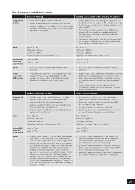
Table 5.4: Summary of the RLTP by Activity Class<br />
<strong>Transport</strong> Planning<br />
Demand Management and Community <strong>Programme</strong>s<br />
Key planned<br />
projects<br />
><br />
><br />
><br />
Crash reduction planning by the NZTA and TAs.<br />
Freight strategies and plans by the NZTA, ARC and TAs.<br />
Corridor designation for the additional Waitemata Harbour<br />
Crossing to improve accessibility for all modes from and to<br />
the North of the Isthmus.<br />
><br />
><br />
><br />
Continued school and work travel planning by ARTA and<br />
the TAs to achieve the target of a 9% reduction in car trips<br />
to school and a reduction in car trips to participating work<br />
places by 2016.<br />
Community road safety projects such as child restraint<br />
clinics, drink driving and driver speed education will<br />
contribute to achieving 400 or fewer fatal and serious<br />
crashes by 2012.<br />
Trialling new and innovative tools and techniques such as<br />
personalised journey planning, carpooling and area-wide<br />
travel planning to increase travel choices.<br />
Value<br />
National GPS<br />
lower and<br />
upper bands<br />
Total = $43.9m<br />
NZTA share = $34.0m<br />
Local share = $9.8m<br />
Proportion of midpoint national share = 32%<br />
Lower = $96m<br />
Upper = $114m<br />
Total = $43.2m<br />
NZTA share = $32.5m<br />
Local share = $10.8m<br />
Proportion of midpoint national share = 23%<br />
Lower = $120m<br />
Upper = $165m<br />
Issues<br />
Effect<br />
required on<br />
GPS impacts<br />
> Sufficient funds are available within the GPS funding > Sufficient funds are available within the GPS funding<br />
allocation.<br />
allocation.<br />
> Anticipated future growth and GPS impacts require step<br />
changes in the way people and goods are moved<br />
compared to current patterns. Good quality transport<br />
planning is essential to achieve these changes.<br />
><br />
><br />
Establishing innovative and effective demand management<br />
techniques and increasing school and workplace travel<br />
plans, offers wider travel choices, which reduces reliance<br />
on travel by private car, which in turn decongests local<br />
roads.<br />
Community road safety programmes significantly<br />
contribute to reducing road deaths and serious injuries on<br />
<strong>Auckland</strong>’s road network.<br />
Walking and Cycling Facilities<br />
Public <strong>Transport</strong> Services<br />
Key planned<br />
projects<br />
><br />
><br />
><br />
><br />
Providing walking and cycling facilities on local roads<br />
affected by the SH20 – SH1 motorway connection.<br />
Improvements to the Northwestern cycleway.<br />
Designing and constructing a cycle connection between<br />
SH1 and SH16 in the central Isthmus.<br />
Constructing over 38 kilometres of off-road walking and<br />
cycling facilities in Flat Bush.<br />
><br />
><br />
><br />
><br />
Improved connectivity into rail stations plus further<br />
development of high-quality, high-frequency services.<br />
Bus service improvements on Isthmus, Waitakere, NW<br />
Rodney, Manukau and Papakura.<br />
Provision of a new ferry service to Hobsonville.<br />
Increasing train services towards 10 minutes peak and 15<br />
minutes off-peak and extending operating hours.<br />
Value<br />
National GPS<br />
lower and<br />
upper bands<br />
Total = $92.2m<br />
NZTA share = $59.9m<br />
Local share = $32.2m<br />
Proportion of midpoint national share = 114%<br />
Lower = $30m<br />
Upper = $75m<br />
Total = $713.6m<br />
NZTA share = $386.7m<br />
Local share = $326.8m<br />
Proportion of midpoint national share = 61%<br />
Lower = $585m<br />
Upper = $675m<br />
Issues<br />
><br />
><br />
The NZTA share required for the <strong>Auckland</strong> region exceeds<br />
the midpoint of the national GPS band by $7 million or<br />
14% and would require 80% of the national upper band.<br />
Walking and cycling schemes associated with motorways<br />
are sometimes necessary to mitigate the barrier effects to<br />
movement on pedestrians and cyclists created by the<br />
building of the motorway. In these cases, where the<br />
purpose of the scheme is to mitigate the negative effects<br />
of the motorway, whether the motorway is existing or<br />
proposed, the costs of these schemes could be borne by<br />
the New and Improved Infrastructure for State Highway<br />
activity class as opposed to the Walking and Cycling activity<br />
class. This would reduce the over-subscription in walking<br />
and cycling facilities.<br />
><br />
><br />
><br />
Sufficient funding is available within the national GPS<br />
allocation. Proposed improvements are limited by the<br />
availability of funds. At this level of funding, some<br />
reductions in bus services will be necessary.<br />
Bus service improvements require integrated ticketing and<br />
fares, and bus priority measures on local roads and State<br />
highways to optimise patronage growth.<br />
Rail service improvements and electrification are dependent<br />
on KiwiRail’s infrastructure programme and timetable.<br />
27