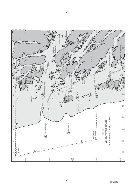
VI VOLUME 6, PART 2, NP 286(2), 2012/13 Published Wk 19/12 –––––––––––––––––– (Last Updates: Weekly Edition No. 6 dated 7 February 2013) PAGE 225, NORWAY, FEDJE, VESSEL TRAFFIC SERVICE, AREA section. Delete and replace by: AREA: The geographical and operational area of the VTS has a boundary of straight lines joining the following points: (1) 60°34′·92N 4°50′·41E (Southernmost point of Alvøy) (2) 60°40′·52N 4°47′·71E (Rubbegarnståna Lt) (3) 60°40′·52N 4°26′·00E (4) 60°56′·85N 4°18′·00E (5) 60°56′·84N 4°45′·75E (Sogneoksen Lt) (6) 60°56′·75N 4°57′·20E (Spafoten Lt) (7) 60°48′·00N 5°11′·30E (Terneskjæret Lt) (8) 60°46′·40N 5°09′·70E (Langøyna) (9) 60°49′·15N 4°45′·37E (Vetegjøgraskjer Lt) (10) 60°34′·62N 4°59′·28E (Basholmen Lt Bn) (11) 60°34′·92N 4°50′·41E (Southernmost point of Alvøy) Norwegian Notice 24/12, (RSDRA2012000261673), 7/13 PAGE 226, NORWAY, FEDJE, diagram FEDJE VESSEL TRAFFIC SERVICE. Delete and replace by diagram FEDJE VESSEL TRAFFIC SERVICE on page 6.7 Norwegian Notice 24/12, (RSDRA2012000261673), 7/13 –––––––––––––––––––––––––––––– VOLUME 6, PART 3, NP 286(3), 2012/13 Published Wk 27/12 –––––––––––––––––– (Last Updates: Weekly Edition No. 6 dated 7 February 2013) PAGE 77, FRANCE (Mediterranean Coast), FOS. Delete entry and replace by: FOS UNCTAD LOCODE: FR FOS Pilots For details see GOLFE DE FOS (Bassins Ouest). Vessel Traffic Service For details see GOLFE DE FOS (Bassins Ouest). Port For details see GOLFE DE FOS (Bassins Ouest). 43°24′N 4°54′E PAGES 81, 82 & 83, FRANCE (Mediterranean Coast), GOLFE DE FOS. Delete entry and replace by: GOLFE DE FOS (Bassins Ouest) NOTE: See also MARSEILLE (Bassins Est). Pilots 43°24′N 5°06′E AREA: Bassins Ouest comprises that part of the port situated in and <strong>to</strong> seaward of the communes of Fos, Lavéra, Port-de-Bouc, Martigues, Étang de Berre, Port-Saint-Louisdu-Rhône (W of the line of longitude of the Sausset-les-Pins Lt (5°06′·47E)). CONTACT DETAILS: Call: Pilotes Fos Pilotes Port-de-Bouc VHF Channel: Ch 14 Telephone: +33(0)4 42062101 E-mail: pilotage.pdb@wanadoo.fr Marseille/Fos <strong>Office</strong> Telephone: +33(0)4 91142910 Fax: +33(0)4 91566579 E-mail: pilote13@pilotage-mrs.fr Website: www.pilotage-mrs.fr HOURS: H24 PROCEDURE: (1) The compulsory pilotage area consists of an area N of latitude 43°19′·00N between the meridians of Faramen Lt (4°41′·24E) and Cap Couronne Lt (5°03′·18E), including the canals, the harbour basins of the inner harbours, the Rhône as far as Arles and the Étang de Berre. (2) Pilotage is compulsory (and is available H24), for the following: (a) Bassins Ouest: Ports of Lavéra, Canal de Caronte, Étang de Berre and Port- Saint-Louis-du-Rhône: vessels of all categories over 50m LOA (b) Bassins Ouest: Port of Fos: (i) Vessels of all categories over 50m LOA (ii) All vessels over 70m LOA other than those transporting hazardous or polluting substances on passage <strong>to</strong> or from Darse 2 (Harbour Basin 2) Container Terminal and Darse 3 (Harbour Basin 3) (3) Pilot boards in the following positions: (a) Vessels transporting hydrocarbons or dangerous cargo and deep draught vessels on passage <strong>to</strong> Fos: On the latitude of Cap Couronne Lt (43°19′·53N) (b) Vessels bound for Port-de-Bouc, Lavéra, Étang de Berre and Port-Saint-Louisdu-Rhône: Between 2·5-4 n miles S of Lavéra Lt buoy (43°22′·53N 4°58′·18E) (c) On request: Between latitudes 43°11′·90N and 43°19′·60N NOTE: The pilotage sub-station at Port-de-Bouc provides Pilots for Lavéra, Canal de Caronte, Martigues, Étang de Berre, Fos and Port-Saint-Louis-de-Rhône. This station comes under the authority of the Marseille/Golfe de Fos Pilotage Offi ce. Vessel Traffic Service AREA: (1) The area of authority of the Marseille/Fos Vessel Traffi c Service comprises a Maritime and River Regulation Zone (ZMFR) and the administrative limits of the Grand Port Maritime de Marseille (GPMM). The maritime limits of the ZMFR are as follows: (a) To the W: The longitude of the Faraman Lt Ho (b) To the S: The latitude of the Planier Lt Ho between Faraman and Planier, then a line that runs from the Planier Lt Ho <strong>to</strong> the Lt on Tiboulen de Maire island (c) To the E: A line that runs from the Lt on Tiboulen de Maire island <strong>to</strong> Cap Croisette then on the coast <strong>to</strong>ward the N French Notice 49/12, (RSDRA2012000248326), 7/13 continued on next page Wk07/13 6.6
F VI V6(2)FEDJE V006 14/01/13 20´ 25´ 30´ 35´ 40 ´ 45´ 50´ 55´ 5° 05´ 10´ 60°56´·85N 4°18´·00E Sogneoksen Spafoten 55´ BYRKNESØYNA West Holmengrå No 2 Mebåen No 3 (By appointment only) Vikingneset Radar FENSFJORDEN J D E E Mongstad Oil Terminal F 200m Terneskjæret 50´ Vetegjøgraskjer J O FOSNØY R D West Fedje Radar FEDJE No 3 (By appointment only) Langøyna 60° 45´ E N FEDJEOSEN No 2 Marøy Radar 60°40´·52N 40°26´·00E Rubbegarnståna RADØY 40´ FEDJE VESSEL TRAFFIC SERVICE Limits of VTS Operational Area Basholmen HOLSNØY 2 0´ 25´ 30´ 35´ 40´ 45´ 50´ 55 ´ 5° 05´ 10´ ONE ALVØY Sture Oil Terminal MANGERSFJORD HJELTEFJORDEN 200m 55´ 50´ 60° 45´ 40´ 35´ 35´ 6.7 Wk07/13