

Admiralty Notices to Mariners - United Kingdom Hydrographic Office
Admiralty Notices to Mariners - United Kingdom Hydrographic Office
Admiralty Notices to Mariners - United Kingdom Hydrographic Office

Create successful ePaper yourself
Turn your PDF publications into a flip-book with our unique Google optimized e-Paper software.
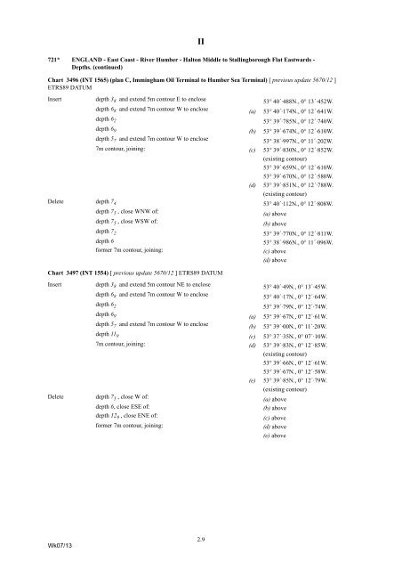
721* ENGLAND - East Coast - River Humber - Hal<strong>to</strong>n Middle <strong>to</strong> Stallingborough Flat Eastwards -<br />
Depths. (continued)<br />
Chart 3496 (INT 1565) (plan C, Immingham Oil Terminal <strong>to</strong> Humber Sea Terminal) [ previous update 5670/12 ]<br />
ETRS89 DATUM<br />
Insert<br />
depth 3 8 and extend 5m con<strong>to</strong>ur E <strong>to</strong> enclose<br />
53° 40´·488N., 0° 13´·452W.<br />
depth 6 8 and extend 7m con<strong>to</strong>ur W <strong>to</strong> enclose<br />
(a) 53° 40´·174N., 0° 12´·641W.<br />
depth 6 2<br />
53° 39´·785N., 0° 12´·740W.<br />
depth 6 9<br />
(b) 53° 39´·674N., 0° 12´·610W.<br />
depth 5 7 and extend 7m con<strong>to</strong>ur W <strong>to</strong> enclose<br />
53° 38´·997N., 0° 11´·202W.<br />
7m con<strong>to</strong>ur, joining: (c) 53° 39´·830N., 0° 12´·852W.<br />
(existing con<strong>to</strong>ur)<br />
53° 39´·659N., 0° 12´·610W.<br />
53° 39´·670N., 0° 12´·580W.<br />
(d) 53° 39´·851N., 0° 12´·788W.<br />
(existing con<strong>to</strong>ur)<br />
Delete depth 7 4<br />
53° 40´·112N., 0° 12´·808W.<br />
depth 7 5 , close WNW of:<br />
(a) above<br />
depth 7 5 , close WSW of:<br />
(b) above<br />
depth 7 2<br />
53° 39´·770N., 0° 12´·811W.<br />
depth 6<br />
53° 38´·986N., 0° 11´·096W.<br />
former 7m con<strong>to</strong>ur, joining:<br />
(c) above<br />
(d) above<br />
II<br />
Chart 3497 (INT 1554) [ previous update 5670/12 ] ETRS89 DATUM<br />
Insert<br />
Delete<br />
depth 3 8 and extend 5m con<strong>to</strong>ur NE <strong>to</strong> enclose<br />
53° 40´·49N., 0° 13´·45W.<br />
depth 6 8 and extend 7m con<strong>to</strong>ur W <strong>to</strong> enclose<br />
53° 40´·17N., 0° 12´·64W.<br />
depth 6 2<br />
53° 39´·79N., 0° 12´·74W.<br />
depth 6 9<br />
(a) 53° 39´·67N., 0° 12´·61W.<br />
depth 5 7 and extend 7m con<strong>to</strong>ur W <strong>to</strong> enclose<br />
(b) 53° 39´·00N., 0° 11´·20W.<br />
depth 11 9<br />
(c) 53° 37´·35N., 0° 07´·10W.<br />
7m con<strong>to</strong>ur, joining: (d) 53° 39´·83N., 0° 12´·85W.<br />
(existing con<strong>to</strong>ur)<br />
53° 39´·66N., 0° 12´·61W.<br />
53° 39´·67N., 0° 12´·58W.<br />
(e) 53° 39´·85N., 0° 12´·79W.<br />
(existing con<strong>to</strong>ur)<br />
depth 7 5 , close W of:<br />
(a) above<br />
depth 6, close ESE of:<br />
(b) above<br />
depth 12 9 , close ENE of:<br />
(c) above<br />
former 7m con<strong>to</strong>ur, joining:<br />
(d) above<br />
(e) above<br />
Wk07/13<br />
2.9


