Admiralty Notices to Mariners - United Kingdom Hydrographic Office
Admiralty Notices to Mariners - United Kingdom Hydrographic Office
Admiralty Notices to Mariners - United Kingdom Hydrographic Office
Create successful ePaper yourself
Turn your PDF publications into a flip-book with our unique Google optimized e-Paper software.
II<br />
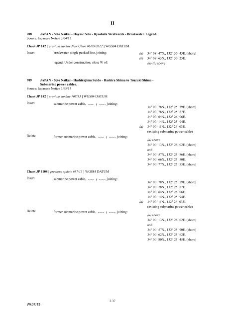
708 JAPAN - Se<strong>to</strong> Naikai - Hayase Se<strong>to</strong> - Ryoshida Westwards - Breakwater. Legend.<br />
Source: Japanese Notice 3/64/13<br />
Chart JP 142 [ previous update New Chart 06/09/2012 ] WGS84 DATUM<br />
Insert breakwater, single pecked line, joining: (a) 34° 08´·47N., 132° 30´·45E. (shore)<br />
legend, Under construction, close W of:<br />
(b)<br />
34° 08´·63N., 132° 30´·25E.<br />
(a)-(b) above<br />
709 JAPAN - Se<strong>to</strong> Naikai - Hashirajima Suido - Hashira Shima <strong>to</strong> Tsuzuki Shima -<br />
Submarine power cables.<br />
Source: Japanese Notice 3/65/13<br />
Chart JP 142 [ previous update 708/13 ] WGS84 DATUM<br />
Insert<br />
submarine power cable, ÉÊÉ<br />
, joining:<br />
34° 00´·78N., 132° 25´·59E. (shore)<br />
34° 00´·78N., 132° 25´·87E.<br />
34° 00´·64N., 132° 26´·06E.<br />
34° 00´·14N., 132° 25´·94E.<br />
Delete<br />
former submarine power cable, ÉÊÉ , joining:<br />
(a)<br />
34° 00´·11N., 132° 26´·03E.<br />
(existing submarine power cable)<br />
(a) above<br />
34° 00´·13N., 132° 26´·02E. (shore)<br />
and<br />
34° 00´·57N., 132° 25´·86E. (shore)<br />
34° 00´·66N., 132° 25´·50E.<br />
34° 00´·77N., 132° 25´·53E. (shore)<br />
Chart JP 1108 [ previous update 687/13 ] WGS84 DATUM<br />
Insert<br />
submarine power cable, ÉÊÉ , joining:<br />
34° 00´·78N., 132° 25´·59E. (shore)<br />
34° 00´·78N., 132° 25´·87E.<br />
34° 00´·64N., 132° 26´·06E.<br />
34° 00´·14N., 132° 25´·94E.<br />
Delete<br />
former submarine power cable, ÉÊÉ , joining:<br />
(a)<br />
34° 00´·11N., 132° 26´·03E.<br />
(existing submarine power cable)<br />
(a) above<br />
34° 00´·13N., 132° 26´·02E. (shore)<br />
and<br />
34° 00´·57N., 132° 25´·90E. (shore)<br />
34° 00´·62N., 132° 25´·62E.<br />
34° 00´·80N., 132° 25´·45E. (shore)<br />
Wk07/13<br />
2.37


