Admiralty Notices to Mariners - United Kingdom Hydrographic Office
Admiralty Notices to Mariners - United Kingdom Hydrographic Office
Admiralty Notices to Mariners - United Kingdom Hydrographic Office
You also want an ePaper? Increase the reach of your titles
YUMPU automatically turns print PDFs into web optimized ePapers that Google loves.
II<br />
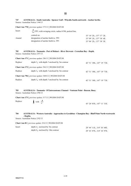
747 AUSTRALIA - South Australia - Spencer Gulf - Whyalla South-eastwards - Anchor berths.<br />
Source: Australian Notice 1/44/13<br />
Chart Aus 778 [ previous update 575/13 ] WGS84 DATUM<br />
Insert<br />
îTP3, with swinging circle, radius 0·5M, pecked line,<br />
centred on:<br />
33° 10´·2S., 137° 37´·2E.<br />
Amend designation of anchor berth <strong>to</strong>, TP2 33° 09´·2S., 137° 38´·4E.<br />
designation of anchor berth <strong>to</strong>, TP1<br />
33° 06´·2S., 137° 38´·5E.<br />
782 AUSTRALIA - Tasmania - Port of Hobart - River Derwent - Cornelian Bay - Depth.<br />
Source: Australian Notice 2/97/13<br />
Chart Aus 171 [ previous update 286/13 ] WGS84 DATUM<br />
Replace<br />
depth 5 4 with depth 5 enclosed by 5m con<strong>to</strong>ur<br />
42° 51´·38S., 147° 19´·73E.<br />
Chart Aus 172 [ previous update 594/13 ] WGS84 DATUM<br />
Replace<br />
depth 5 4 with depth 5 enclosed by 5m con<strong>to</strong>ur<br />
42° 51´·38S., 147° 19´·73E.<br />
Chart Aus 796 [ previous update 5408/12 ] WGS84 DATUM<br />
Replace<br />
depth 5 4 with depth 5 enclosed by 5m con<strong>to</strong>ur<br />
42° 51´·38S., 147° 19´·73E.<br />
783 AUSTRALIA - Tasmania - D’Entrecasteaux Channel - Ventenat Point - Beacon. Buoy.<br />
Source: Australian Notice 2/96/13<br />
Chart Aus 173 [ previous update 317/13 ] WGS84 DATUM<br />
Replace<br />
K


