Admiralty Notices to Mariners - United Kingdom Hydrographic Office
Admiralty Notices to Mariners - United Kingdom Hydrographic Office
Admiralty Notices to Mariners - United Kingdom Hydrographic Office
Create successful ePaper yourself
Turn your PDF publications into a flip-book with our unique Google optimized e-Paper software.
II<br />
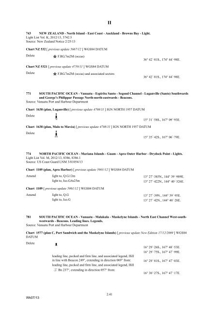
743 NEW ZEALAND - North Island - East Coast - Auckland - Browns Bay - Light.<br />
Light List Vol. K, 2012/13, 3742.5<br />
Source: New Zealand Notice 2/25/13<br />
Chart NZ 532 [ previous update 5667/12 ] WGS84 DATUM<br />
Delete<br />
F.RG.7m2M (occas) 36° 42´·81S., 174° 44´·98E.<br />
Chart NZ 5321 [ previous update 4759/11 ] WGS84 DATUM<br />
Delete<br />
F.RG.7m2M (occas) and associated sec<strong>to</strong>rs 36° 42´·81S., 174° 44´·98E.<br />
771 SOUTH PACIFIC OCEAN - Vanuatu - Espiritu San<strong>to</strong> - Segond Channel - Luganville (San<strong>to</strong>) Southwards<br />
and George’s Philippar Passage North-north-eastwards - Beacons.<br />
Source: Vanuatu Port and Harbour Department<br />
Chart 1638 (plan, Luganville) [ previous update 4708/11 ] IGN NORTH 1957 DATUM<br />
Delete<br />
K=x<br />
15° 31´·58S., 167° 09´·93E.<br />
Chart 1638 (plan, Malo <strong>to</strong> Mavéa) [ previous update 4708/11 ] IGN NORTH 1957 DATUM<br />
Delete<br />
K>y<br />
15° 35´·42S., 167° 06´·79E.<br />
774 NORTH PACIFIC OCEAN - Mariana Islands - Guam - Apra Outer Harbor - Drydock Point - Lights.<br />
Light List Vol. M, 2012/13, 8386, 8386.1<br />
Source: US Coast Guard LNM 3/81054/13<br />
Chart 1109 (plan, Apra Harbor) [ previous update 5901/12 ] WGS84 DATUM<br />
Amend light <strong>to</strong>, Q.G.12m 13° 27´·385N., 144° 39´·989E.<br />
light <strong>to</strong>, Iso.G.6s25m<br />
13° 27´·422N., 144° 40´·326E.<br />
Chart 1109 [ previous update 5901/12 ] WGS84 DATUM<br />
Amend light <strong>to</strong>, Q.G 13° 27´·39N., 144° 39´·95E.<br />
light <strong>to</strong>, Iso.G<br />
13° 27´·42N., 144° 40´·28E.<br />
781 SOUTH PACIFIC OCEAN - Vanuatu - Malakula - Maskelyne Islands - North East Channel West-southwestwards<br />
- Beacons. Leading lines. Legends.<br />
Source: Vanuatu Port and Harbour Department<br />
Chart 1577 (plan C, Port Sandwich and the Maskelyne Islands) [ previous update New Edition 17/12/2009 ] WGS84<br />
DATUM<br />
Delete<br />
K<br />
16° 29´·26S., 167° 48´·53E.<br />
16° 29´·75S., 167° 47´·99E.<br />
leading line, pecked and firm line, and associated legend, Hill<br />
in line with Beacon 249°, extending in direction 069° from: 16° 29´·81S., 167° 47´·03E.<br />
leading line, pecked and firm line, and associated legend, Hill<br />
çBn 237°, extending in direction 057° from:<br />
16° 30´·27S., 167° 47´·17E.<br />
Wk07/13<br />
2.41


