Admiralty Notices to Mariners - United Kingdom Hydrographic Office
Admiralty Notices to Mariners - United Kingdom Hydrographic Office
Admiralty Notices to Mariners - United Kingdom Hydrographic Office
You also want an ePaper? Increase the reach of your titles
YUMPU automatically turns print PDFs into web optimized ePapers that Google loves.
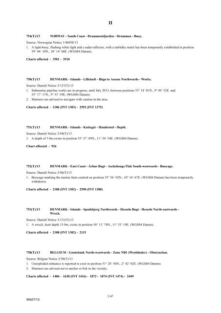
II<br />
754(T)/13<br />
NORWAY - South Coast - Drammensfjorden - Drammen - Buoy.<br />
Source: Norwegian Notice 1/46058/13<br />
1. A light-buoy, flashing white light and a radar reflec<strong>to</strong>r, with a turbidity meter has been temporarily established in position<br />
59° 44´·10N., 10° 14´·60E. (WGS84 Datum).<br />
Charts affected - 3501 - 3510<br />
750(T)/13<br />
DENMARK - Islands - Lillebælt - Bågø <strong>to</strong> Assens Northwards - Works.<br />
Source: Danish Notice 3/127(T)/13<br />
1. Submarine pipeline works are in progress, until July 2013, between positions 55° 18´·01N., 9° 49´·52E. and<br />
55° 17´·17N., 9° 53´·39E. (WGS84 Datum).<br />
2. <strong>Mariners</strong> are advised <strong>to</strong> navigate with caution in the area.<br />
Charts affected - 2106 (INT 1303) - 2592 (INT 1375)<br />
751(T)/13<br />
DENMARK - Islands - Kattegat - Hundested - Depth.<br />
Source: Danish Notice 2/94(T)/13<br />
1. A depth of 3·8m exists in position 55° 57´·89N., 11° 50´·54E. (WGS84 Datum).<br />
Chart affected - 926<br />
752(T)/13<br />
DENMARK - East Coast - Århus Bugt - Aschehougs Flak South-westwards - Buoyage.<br />
Source: Danish Notice 2/96(T)/13<br />
1. Buoyage marking the marine farm centred on position 55° 56´·92N., 10° 16´·67E. (WGS84 Datum) has been temporarily<br />
withdrawn.<br />
Charts affected - 2108 (INT 1302) - 2590 (INT 1380)<br />
753(T)/13 DENMARK - Islands - Spodsbjerg Northwards - Hesselø Bugt - Hesselø North-eastwards -<br />
Wreck.<br />
Source: Danish Notice 3/131(T)/13<br />
1. A wreck, least depth 13·9m, exists in position 56° 13´·74N., 11° 55´·19E. (WGS84 Datum).<br />
Charts affected - 2108 (INT 1302) - 2115<br />
758(T)/13<br />
BELGIUM - Gootebank North-westwards - Zone NB1 (Westhinder) - Obstruction.<br />
Source: Belgian Notice 2/50(T)/13<br />
1. Unexploded ordnance is reported <strong>to</strong> exist in position 51° 28´·58N., 2° 42´·02E. (WGS84 Datum).<br />
2. <strong>Mariners</strong> are advised not <strong>to</strong> anchor or fish in the vicinity.<br />
Charts affected - 1406 - 1630 (INT 1416) - 1872 - 1874 (INT 1474) - 2449<br />
Wk07/13<br />
2.47


