

Admiralty Notices to Mariners - United Kingdom Hydrographic Office
Admiralty Notices to Mariners - United Kingdom Hydrographic Office
Admiralty Notices to Mariners - United Kingdom Hydrographic Office

You also want an ePaper? Increase the reach of your titles
YUMPU automatically turns print PDFs into web optimized ePapers that Google loves.
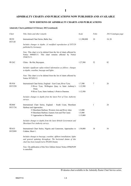
I<br />
ADMIRALTY CHARTS AND PUBLICATIONS NOW PUBLISHED AND AVAILABLE<br />
NEW EDITIONS OF ADMIRALTY CHARTS AND PUBLICATIONS<br />
<strong>Admiralty</strong> Charts published 14 February 2013 (continued)<br />
Chart Title, limits and other remarks Scale Folio 2013 Catalogue page<br />
259<br />
INT120<br />
1262<br />
International Chart Series, Baltic Sea.<br />
Includes changes <strong>to</strong> depths. (A modified reproduction of INT120<br />
published by Germany).<br />
Note: This chart is <strong>to</strong> be deleted from the list of charts affected by<br />
Notice 4460(P)/11. This chart remains affected by Notice<br />
2564(T)/11.<br />
China – Bo Hai, Bayuquan.<br />
Includes significant safety-related information as follows: changes<br />
<strong>to</strong> depths, coastline, buoyage and lights.<br />
1:1,500,000 10 18, 20<br />
1:27,500 52 82<br />
Note: This chart is <strong>to</strong> be deleted from the list of charts affected by<br />
Notice 5072(P)/12.<br />
1934<br />
INT1550<br />
International Chart Series, England – East Coast, River Tyne.<br />
A River Tyne, Willing<strong>to</strong>n Quay <strong>to</strong> Saint Anthony’s<br />
Point.<br />
B River Tyne, Saint Anthony’s Point <strong>to</strong> Duns<strong>to</strong>n.<br />
1:7,500<br />
1:12,500<br />
1:12,500<br />
7 26<br />
Includes changes <strong>to</strong> depths from the latest Port of Tyne Authority<br />
surveys.<br />
2044<br />
INT1734<br />
International Chart Series, England – South Coast, Shoreham<br />
Harbour and Approaches.<br />
A Shoreham Harbour, Western Arm and River Adur.<br />
B Shoreham Harbour, Eastern Arm and The Canal.<br />
C Approaches <strong>to</strong> Shoreham.<br />
1:5,000<br />
1:5,000<br />
1:15,000<br />
1 24<br />
Includes changes <strong>to</strong> depths from the latest British Government and<br />
Shoreham Port Authority surveys.<br />
3433<br />
INT2899<br />
International Chart Series, Nigeria and Cameroon, Approaches <strong>to</strong><br />
Calabar, Sheet 1.<br />
Includes changes <strong>to</strong> buoyage, coastline, offshore installations, lights<br />
and general updating throughout. The horizontal datum of this<br />
chart has been transferred <strong>to</strong> WGS84 Datum.<br />
Note: On publication of this New Edition former Notice 6996(P)/09<br />
is cancelled.<br />
1:50,000 34 54<br />
denotes chart available in the <strong>Admiralty</strong> Raster Chart Service series.<br />
Wk07/13<br />
1.8


