Admiralty Notices to Mariners - United Kingdom Hydrographic Office
Admiralty Notices to Mariners - United Kingdom Hydrographic Office
Admiralty Notices to Mariners - United Kingdom Hydrographic Office
You also want an ePaper? Increase the reach of your titles
YUMPU automatically turns print PDFs into web optimized ePapers that Google loves.
II<br />
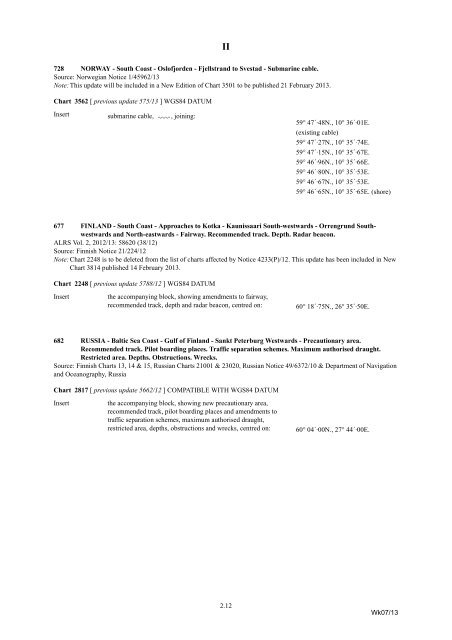
728 NORWAY - South Coast - Oslofjorden - Fjellstrand <strong>to</strong> Svestad - Submarine cable.<br />
Source: Norwegian Notice 1/45962/13<br />
Note: This update will be included in a New Edition of Chart 3501 <strong>to</strong> be published 21 February 2013.<br />
Chart 3562 [ previous update 575/13 ] WGS84 DATUM<br />
Insert<br />
submarine cable, É<br />
, joining:<br />
59° 47´·48N., 10° 36´·01E.<br />
(existing cable)<br />
59° 47´·27N., 10° 35´·74E.<br />
59° 47´·15N., 10° 35´·67E.<br />
59° 46´·96N., 10° 35´·66E.<br />
59° 46´·80N., 10° 35´·53E.<br />
59° 46´·67N., 10° 35´·53E.<br />
59° 46´·65N., 10° 35´·65E. (shore)<br />
677 FINLAND - South Coast - Approaches <strong>to</strong> Kotka - Kaunissaari South-westwards - Orrengrund Southwestwards<br />
and North-eastwards - Fairway. Recommended track. Depth. Radar beacon.<br />
ALRS Vol. 2, 2012/13: 58620 (38/12)<br />
Source: Finnish Notice 21/224/12<br />
Note: Chart 2248 is <strong>to</strong> be deleted from the list of charts affected by Notice 4233(P)/12. This update has been included in New<br />
Chart 3814 published 14 February 2013.<br />
Chart 2248 [ previous update 5788/12 ] WGS84 DATUM<br />
Insert<br />
the accompanying block, showing amendments <strong>to</strong> fairway,<br />
recommended track, depth and radar beacon, centred on:<br />
60° 18´·75N., 26° 35´·50E.<br />
682 RUSSIA - Baltic Sea Coast - Gulf of Finland - Sankt Peterburg Westwards - Precautionary area.<br />
Recommended track. Pilot boarding places. Traffic separation schemes. Maximum authorised draught.<br />
Restricted area. Depths. Obstructions. Wrecks.<br />
Source: Finnish Charts 13, 14 & 15, Russian Charts 21001 & 23020, Russian Notice 49/6372/10 & Department of Navigation<br />
and Oceanography, Russia<br />
Chart 2817 [ previous update 5662/12 ] COMPATIBLE WITH WGS84 DATUM<br />
Insert<br />
the accompanying block, showing new precautionary area,<br />
recommended track, pilot boarding places and amendments <strong>to</strong><br />
traffic separation schemes, maximum authorised draught,<br />
restricted area, depths, obstructions and wrecks, centred on:<br />
60° 04´·00N., 27° 44´·00E.<br />
2.12<br />
Wk07/13


