Admiralty Notices to Mariners - United Kingdom Hydrographic Office
Admiralty Notices to Mariners - United Kingdom Hydrographic Office
Admiralty Notices to Mariners - United Kingdom Hydrographic Office
You also want an ePaper? Increase the reach of your titles
YUMPU automatically turns print PDFs into web optimized ePapers that Google loves.
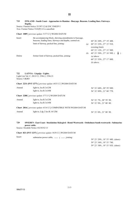
II<br />
719 FINLAND - South Coast - Approaches <strong>to</strong> Hamina - Buoyage. Beacons. Leading lines. Fairways.<br />
Depths.<br />
Source: Finnish Notice 35/387/12 & ENC FI4EIJV1<br />
Note: Former Notice 5143(P)/12 is cancelled.<br />
Chart 1089 [ previous update 5157/12 ] WGS84 DATUM<br />
Insert<br />
the accompanying block, showing amendments <strong>to</strong> buoyage,<br />
beacons, leading lines, fairways and depths, centred on:<br />
60° 26´·20N., 27° 19´·40E.<br />
limit of fairway, pecked line, joining: (a) 60° 23´·23N., 27° 15´·91E.<br />
(existing limit)<br />
60° 23´·12N., 27° 15´·90E.<br />
(b) 60° 23´·59N., 27° 18´·99E. ( T§<br />
)<br />
Delete former limit of fairway, pecked line, joining: (a) above<br />
60° 23´·55N., 27° 17´·80E.<br />
(b) above<br />
722 LATVIA - Liepāja - Lights.<br />
Light List Vol. C, 2012/13, 3396.2, 3396.21<br />
Source: UKHO<br />
Chart 2231 (INT 1277) [ previous update 4655/12 ] WGS84 DATUM<br />
Amend light <strong>to</strong>, Iso.R.3s12M 56° 32´·68N., 20° 59´·88E.<br />
light <strong>to</strong>, Iso.R.3s14M<br />
56° 32´·89N., 21° 00´·77E.<br />
Chart 2288 [ previous update 377/13 ] WGS84 DATUM<br />
Amend light <strong>to</strong>, Iso.R.3s12M 56° 32´·7N., 20° 59´·9E.<br />
light <strong>to</strong>, Iso.R.3s14M<br />
56° 32´·9N., 21° 00´·8E.<br />
Chart 2816 [ previous update 4314/12 ] COMPATIBLE WITH WGS84 DATUM<br />
Amend light <strong>to</strong>, Ldg 2 Iso.R.14/12M 56° 33´·0N., 21° 00´·9E.<br />
729 SWEDEN - East Coast - S<strong>to</strong>ckholms Skärgård - Hemö Westwards - Ostholmen South-westwards - Submarine<br />
power cable.<br />
Source: Swedish Notice 432/8352/13<br />
Chart 821 (INT 1237) [ previous update 5639/12 ] WGS84 DATUM<br />
Insert<br />
submarine power cable, ÉÊÉ , joining:<br />
59° 23´·29N., 18° 53´·48E. (shore)<br />
59° 23´·34N., 18° 53´·78E.<br />
59° 23´·38N., 18° 53´·83E. (shore)<br />
Wk07/13<br />
2.13


