Admiralty Notices to Mariners - United Kingdom Hydrographic Office
Admiralty Notices to Mariners - United Kingdom Hydrographic Office
Admiralty Notices to Mariners - United Kingdom Hydrographic Office
You also want an ePaper? Increase the reach of your titles
YUMPU automatically turns print PDFs into web optimized ePapers that Google loves.
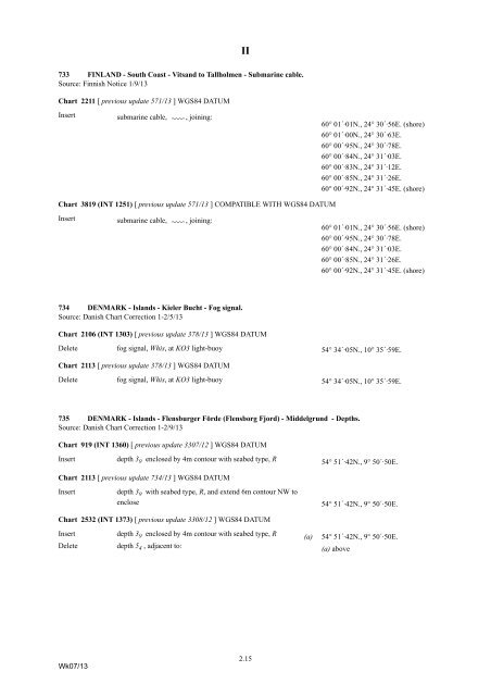
II<br />
733 FINLAND - South Coast - Vitsand <strong>to</strong> Tallholmen - Submarine cable.<br />
Source: Finnish Notice 1/9/13<br />
Chart 2211 [ previous update 571/13 ] WGS84 DATUM<br />
Insert<br />
submarine cable, É<br />
, joining:<br />
60° 01´·01N., 24° 30´·56E. (shore)<br />
60° 01´·00N., 24° 30´·63E.<br />
60° 00´·95N., 24° 30´·78E.<br />
60° 00´·84N., 24° 31´·03E.<br />
60° 00´·83N., 24° 31´·12E.<br />
60° 00´·85N., 24° 31´·26E.<br />
60° 00´·92N., 24° 31´·45E. (shore)<br />
Chart 3819 (INT 1251) [ previous update 571/13 ] COMPATIBLE WITH WGS84 DATUM<br />
Insert<br />
submarine cable, É<br />
, joining:<br />
60° 01´·01N., 24° 30´·56E. (shore)<br />
60° 00´·95N., 24° 30´·78E.<br />
60° 00´·84N., 24° 31´·03E.<br />
60° 00´·85N., 24° 31´·26E.<br />
60° 00´·92N., 24° 31´·45E. (shore)<br />
734 DENMARK - Islands - Kieler Bucht - Fog signal.<br />
Source: Danish Chart Correction 1-2/5/13<br />
Chart 2106 (INT 1303) [ previous update 378/13 ] WGS84 DATUM<br />
Delete fog signal, Whis, at KO3 light-buoy 54° 34´·05N., 10° 35´·59E.<br />
Chart 2113 [ previous update 378/13 ] WGS84 DATUM<br />
Delete fog signal, Whis, at KO3 light-buoy 54° 34´·05N., 10° 35´·59E.<br />
735 DENMARK - Islands - Flensburger Förde (Flensborg Fjord) - Middelgrund - Depths.<br />
Source: Danish Chart Correction 1-2/9/13<br />
Chart 919 (INT 1360) [ previous update 3307/12 ] WGS84 DATUM<br />
Insert<br />
depth 3 9 enclosed by 4m con<strong>to</strong>ur with seabed type, R<br />
54° 51´·42N., 9° 50´·50E.<br />
Chart 2113 [ previous update 734/13 ] WGS84 DATUM<br />
Insert<br />
depth 3 9 with seabed type, R, and extend 6m con<strong>to</strong>ur NW <strong>to</strong><br />
enclose<br />
54° 51´·42N., 9° 50´·50E.<br />
Chart 2532 (INT 1373) [ previous update 3308/12 ] WGS84 DATUM<br />
Insert depth 3 9 enclosed by 4m con<strong>to</strong>ur with seabed type, R (a) 54° 51´·42N., 9° 50´·50E.<br />
Delete depth 5 4 , adjacent <strong>to</strong>: (a) above<br />
Wk07/13<br />
2.15


