

Admiralty Notices to Mariners - United Kingdom Hydrographic Office
Admiralty Notices to Mariners - United Kingdom Hydrographic Office
Admiralty Notices to Mariners - United Kingdom Hydrographic Office

Create successful ePaper yourself
Turn your PDF publications into a flip-book with our unique Google optimized e-Paper software.
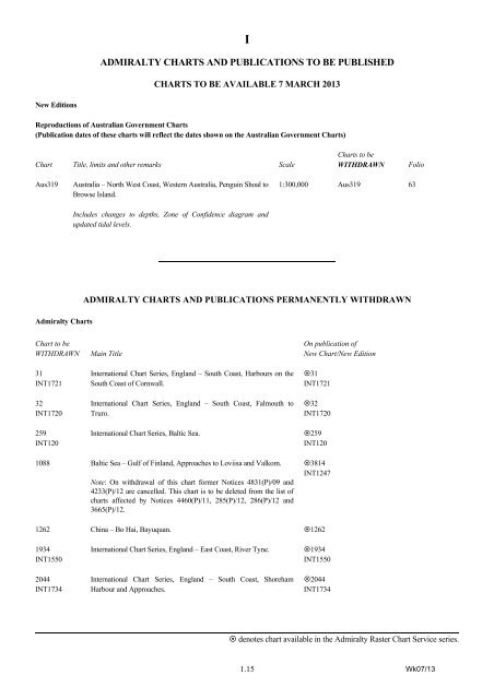
I<br />
ADMIRALTY CHARTS AND PUBLICATIONS TO BE PUBLISHED<br />
CHARTS TO BE AVAILABLE 7 MARCH 2013<br />
New Editions<br />
Reproductions of Australian Government Charts<br />
(Publication dates of these charts will reflect the dates shown on the Australian Government Charts)<br />
Chart Title, limits and other remarks Scale<br />
Charts <strong>to</strong> be<br />
WITHDRAWN<br />
Folio<br />
Aus319<br />
Australia – North West Coast, Western Australia, Penguin Shoal <strong>to</strong><br />
Browse Island.<br />
Includes changes <strong>to</strong> depths, Zone of Confidence diagram and<br />
updated tidal levels.<br />
1:300,000 Aus319 63<br />
ADMIRALTY CHARTS AND PUBLICATIONS PERMANENTLY WITHDRAWN<br />
<strong>Admiralty</strong> Charts<br />
Chart <strong>to</strong> be<br />
WITHDRAWN<br />
31<br />
INT1721<br />
32<br />
INT1720<br />
259<br />
INT120<br />
Main Title<br />
International Chart Series, England – South Coast, Harbours on the<br />
South Coast of Cornwall.<br />
International Chart Series, England – South Coast, Falmouth <strong>to</strong><br />
Truro.<br />
International Chart Series, Baltic Sea.<br />
On publication of<br />
New Chart/New Edition<br />
31<br />
INT1721<br />
32<br />
INT1720<br />
259<br />
INT120<br />
1088 Baltic Sea – Gulf of Finland, Approaches <strong>to</strong> Loviisa and Valkom.<br />
Note: On withdrawal of this chart former <strong>Notices</strong> 4831(P)/09 and<br />
4233(P)/12 are cancelled. This chart is <strong>to</strong> be deleted from the list of<br />
charts affected by <strong>Notices</strong> 4460(P)/11, 285(P)/12, 286(P)/12 and<br />
3665(P)/12.<br />
3814<br />
INT1247<br />
1262 China – Bo Hai, Bayuquan. 1262<br />
1934<br />
INT1550<br />
2044<br />
INT1734<br />
International Chart Series, England – East Coast, River Tyne.<br />
International Chart Series, England – South Coast, Shoreham<br />
Harbour and Approaches.<br />
1934<br />
INT1550<br />
2044<br />
INT1734<br />
denotes chart available in the <strong>Admiralty</strong> Raster Chart Service series.<br />
1.15 Wk07/13


