Admiralty Notices to Mariners - United Kingdom Hydrographic Office
Admiralty Notices to Mariners - United Kingdom Hydrographic Office
Admiralty Notices to Mariners - United Kingdom Hydrographic Office
You also want an ePaper? Increase the reach of your titles
YUMPU automatically turns print PDFs into web optimized ePapers that Google loves.
II<br />
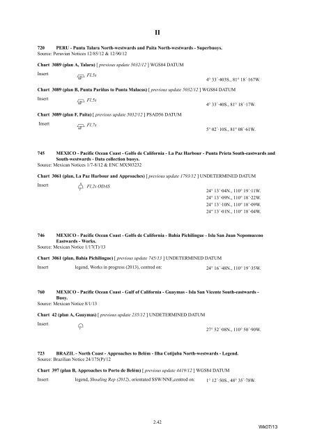
720 PERU - Punta Talara North-westwards and Paita North-westwards - Superbuoys.<br />
Source: Peruvian <strong>Notices</strong> 12/85/12 & 12/90/12<br />
Chart 3089 (plan A, Talara) [ previous update 5032/12 ] WGS84 DATUM<br />
Insert<br />
Pp Fl.5s 4° 33´·403S., 81° 18´·167W.<br />
Chart 3089 (plan B, Punta Pariñas <strong>to</strong> Punta Malacas) [ previous update 5032/12 ] WGS84 DATUM<br />
Insert<br />
Pp Fl.5s 4° 33´·40S., 81° 18´·17W.<br />
Chart 3089 (plan F, Paita) [ previous update 5032/12 ] PSAD56 DATUM<br />
Insert<br />
Pp Fl.7s 5° 02´·10S., 81° 08´·61W.<br />
745 MEXICO - Pacific Ocean Coast - Golfo de California - La Paz Harbour - Punta Prieta South-eastwards and<br />
South-westwards - Data collection buoys.<br />
Source: Mexican <strong>Notices</strong> 1/7-8/12 & ENC MX503232<br />
Chart 3061 (plan, La Paz Harbour and Approaches) [ previous update 1793/12 ] UNDETERMINED DATUM<br />
Insert<br />
EÜf<br />
Fl.2s ODAS<br />
24° 13´·04N., 110° 19´·11W.<br />
24° 13´·09N., 110° 18´·22W.<br />
24° 13´·10N., 110° 18´·09W.<br />
24° 13´·01N., 110° 18´·04W.<br />
746 MEXICO - Pacific Ocean Coast - Golfo de California - Bahía Pichilingue - Isla San Juan Nepomuceno<br />
Eastwards - Works.<br />
Source: Mexican Notice 1/17(T)/13<br />
Chart 3061 (plan, Bahía Pichilingue) [ previous update 745/13 ] UNDETERMINED DATUM<br />
Insert legend, Works in progress (2013), centred on: 24° 16´·48N., 110° 19´·35W.<br />
760 MEXICO - Pacific Ocean Coast - Gulf of California - Guaymas - Isla San Vicente South-eastwards -<br />
Buoy.<br />
Source: Mexican Notice 8/1/13<br />
Chart 42 (plan A, Guaymas) [ previous update 235/12 ] UNDETERMINED DATUM<br />
Insert<br />
Ef<br />
27° 52´·08N., 110° 50´·90W.<br />
723 BRAZIL - North Coast - Approaches <strong>to</strong> Belém - Ilha Cotijuba North-westwards - Legend.<br />
Source: Brazilian Notice 24/175(P)/12<br />
Chart 397 (plan B, Approaches <strong>to</strong> Por<strong>to</strong> de Belém) [ previous update 4419/12 ] WGS84 DATUM<br />
Insert legend, Shoaling Rep (2012), orientated SSW/NNE,centred on: 1° 12´·50S., 48° 35´·78W.<br />
2.42<br />
Wk07/13


