

Admiralty Notices to Mariners - United Kingdom Hydrographic Office
Admiralty Notices to Mariners - United Kingdom Hydrographic Office
Admiralty Notices to Mariners - United Kingdom Hydrographic Office

Create successful ePaper yourself
Turn your PDF publications into a flip-book with our unique Google optimized e-Paper software.
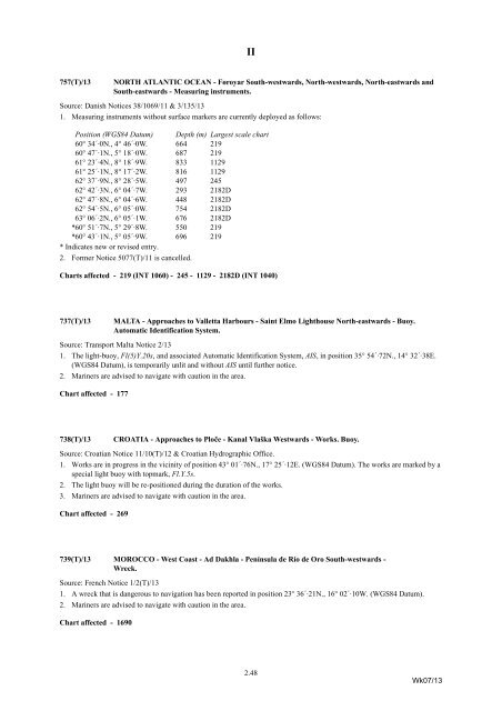
II<br />
757(T)/13<br />
NORTH ATLANTIC OCEAN - Føroyar South-westwards, North-westwards, North-eastwards and<br />
South-eastwards - Measuring instruments.<br />
Source: Danish <strong>Notices</strong> 38/1069/11 & 3/135/13<br />
1. Measuring instruments without surface markers are currently deployed as follows:<br />
Position (WGS84 Datum) Depth (m) Largest scale chart<br />
60° 34´·0N., 4° 46´·0W. 664 219<br />
60° 47´·1N., 5° 18´·0W. 687 219<br />
61° 23´·4N., 8° 18´·9W. 833 1129<br />
61° 25´·1N., 8° 17´·2W. 816 1129<br />
62° 37´·9N., 8° 28´·5W. 497 245<br />
62° 42´·3N., 6° 04´·7W. 293 2182D<br />
62° 47´·8N., 6° 04´·6W. 448 2182D<br />
62° 54´·5N., 6° 05´·0W. 754 2182D<br />
63° 06´·2N., 6° 05´·1W. 676 2182D<br />
*60° 51´·7N., 5° 29´·8W. 550 219<br />
*60° 43´·1N., 5° 05´·9W. 696 219<br />
* Indicates new or revised entry.<br />
2. Former Notice 5077(T)/11 is cancelled.<br />
Charts affected - 219 (INT 1060) - 245 - 1129 - 2182D (INT 1040)<br />
737(T)/13<br />
MALTA - Approaches <strong>to</strong> Valletta Harbours - Saint Elmo Lighthouse North-eastwards - Buoy.<br />
Au<strong>to</strong>matic Identification System.<br />
Source: Transport Malta Notice 2/13<br />
1. The light-buoy, Fl(5)Y.20s, and associated Au<strong>to</strong>matic Identification System, AIS, in position 35° 54´·72N., 14° 32´·38E.<br />
(WGS84 Datum), is temporarily unlit and without AIS until further notice.<br />
2. <strong>Mariners</strong> are advised <strong>to</strong> navigate with caution in the area.<br />
Chart affected - 177<br />
738(T)/13<br />
CROATIA - Approaches <strong>to</strong> Ploče - Kanal Vlaška Westwards - Works. Buoy.<br />
Source: Croatian Notice 11/10(T)/12 & Croatian <strong>Hydrographic</strong> <strong>Office</strong>.<br />
1. Works are in progress in the vicinity of position 43° 01´·76N., 17° 25´·12E. (WGS84 Datum). The works are marked by a<br />
special light buoy with <strong>to</strong>pmark, Fl.Y.5s.<br />
2. The light buoy will be re-positioned during the duration of the works.<br />
3. <strong>Mariners</strong> are advised <strong>to</strong> navigate with caution in the area.<br />
Chart affected - 269<br />
739(T)/13 MOROCCO - West Coast - Ad Dakhla - Península de Río de Oro South-westwards -<br />
Wreck.<br />
Source: French Notice 1/2(T)/13<br />
1. A wreck that is dangerous <strong>to</strong> navigation has been reported in position 23° 36´·21N., 16° 02´·10W. (WGS84 Datum).<br />
2. <strong>Mariners</strong> are advised <strong>to</strong> navigate with caution in the area.<br />
Chart affected - 1690<br />
2.48<br />
Wk07/13


