AIDJEX Bulletin #40 - Polar Science Center - University of Washington
AIDJEX Bulletin #40 - Polar Science Center - University of Washington
AIDJEX Bulletin #40 - Polar Science Center - University of Washington

You also want an ePaper? Increase the reach of your titles
YUMPU automatically turns print PDFs into web optimized ePapers that Google loves.
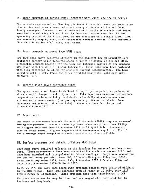
14. Ocean currents at manned camps (combined with winds and ice velocity)<br />
The manned camps served as floating platforms from which ocean currents relative<br />
to ice motion were measured continuously at depths <strong>of</strong> 2 m and 30 m.<br />
Hourly averages <strong>of</strong> ocean currents combined with hourly 10 m winds and 3-hour<br />
smoothed ice velocity (files 12 and 2) from each manned camp for the full<br />
operating period <strong>of</strong> the <strong>AIDJEX</strong> program are available on a single file. They<br />
are sorted by camp by time, with separation markers between 20-day intervals.<br />
This file is called WIIIO Wind, Ice, Ocean.<br />
15. Ocean currents measured from RAMS buoys<br />
Two RAMS spar buoys deployed <strong>of</strong>fshore in the Beaufort Sea in November 1975<br />
contained sensors which measured ocean currents at depths <strong>of</strong> 2 m and 30 m.<br />
A magnetic compass heading for the buoy and internal bearing <strong>of</strong> the sensors<br />
are given with the data at 3-hour intervals. These data have been combined<br />
with buoy positions to allow for absolute current determination. One buoy<br />
operated until 1 Oct. 1976; the other provided meaningful data only until<br />
28 March 1976.<br />
16. Oceanic mixed layer characteristics<br />
The upper ocean mixed layer is defined in depth by the point, or points, at<br />
which a rapid change in salinity occurs. This layer was measured for surface<br />
temperature, surface salinity, and depth twice daily at each manned camp.<br />
All available measurements (one per day) were published in tabular form<br />
in <strong>AIDJEX</strong> <strong>Bulletin</strong> No. 32 (June 1976). These are data for the period<br />
11 April-29 June 1975.<br />
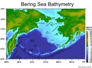
17. Ocean depth<br />
The depth <strong>of</strong> the ocean beneath the path <strong>of</strong> the main <strong>AIDJEX</strong> camp was measured<br />
during two periods. Acoustic soundings were taken every hour from 25 May<br />
to 3 August 1975 and from 18 December 1975 to 25 April 1976. Round-trip<br />
time <strong>of</strong> sound travel is given together with interpreted depth. A file <strong>of</strong><br />
daily average depth merged with NavSat position is also available.<br />
18. Surface pressure (Val i dated) , <strong>of</strong>fshore RAMS buoys<br />
Four RAMS buoys deployed <strong>of</strong>fshore in the Beaufort Sea measured surface pressure.<br />
These measurements have been corrected for scale and sensor drift and<br />
have been smoothed and interpolated to 3-hour readings. Buoys were operational<br />
for the following periods: buoy 207, 18 March-28 August 1976; buoy 1015,<br />
23 March-30 September 1976; buoy 1245, 4 November 1975-1 October 1976; and<br />
buoy 1416, 5 November 1975-28 March 1976.<br />
In March 1977 two more RAMS buoys with pressure sensors were deployed <strong>of</strong>fshore<br />
in the OCS region. Buoy 1023 operated from 18 March to 10 July, buoy 1617<br />
from 8 March to 12 October. These pressure data were transferred to OCS.<br />
The data are sorted by buoy by time, and are merged with buoy position in<br />
latitude and longitude.<br />
194