Workbench Release History
Workbench Release History
Workbench Release History
You also want an ePaper? Increase the reach of your titles
YUMPU automatically turns print PDFs into web optimized ePapers that Google loves.
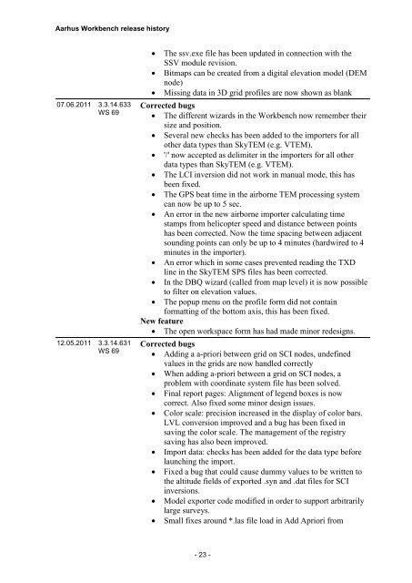
Aarhus <strong>Workbench</strong> release history<br />
07.06.2011 3.3.14.633<br />
WS 69<br />
12.05.2011 3.3.14.631<br />
WS 69<br />
<br />
<br />
<br />
The ssv.exe file has been updated in connection with the<br />
SSV module revision.<br />
Bitmaps can be created from a digital elevation model (DEM<br />
node)<br />
Missing data in 3D grid profiles are now shown as blank<br />
Corrected bugs<br />
The different wizards in the <strong>Workbench</strong> now remember their<br />
size and position.<br />
Several new checks has been added to the importers for all<br />
other data types than SkyTEM (e.g. VTEM).<br />
'/' now accepted as delimiter in the importers for all other<br />
data types than SkyTEM (e.g. VTEM).<br />
The LCI inversion did not work in manual mode, this has<br />
been fixed.<br />
The GPS beat time in the airborne TEM processing system<br />
can now be up to 5 sec.<br />
An error in the new airborne importer calculating time<br />
stamps from helicopter speed and distance between points<br />
has been corrected. Now the time spacing between adjacent<br />
sounding points can only be up to 4 minutes (hardwired to 4<br />
minutes in the importer).<br />
An error which in some cases prevented reading the TXD<br />
line in the SkyTEM SPS files has been corrected.<br />
In the DBQ wizard (called from map level) it is now possible<br />
to filter on elevation values.<br />
The popup menu on the profile form did not contain<br />
formatting of the bottom axis, this has been fixed.<br />
New feature<br />
The open workspace form has had made minor redesigns.<br />
Corrected bugs<br />
Adding a a-priori between grid on SCI nodes, undefined<br />
values in the grids are now handled correctly<br />
When adding a-priori between a grid on SCI nodes, a<br />
problem with coordinate system file has been solved.<br />
Final report pages: Alignment of legend boxes is now<br />
correct. Also fixed some minor design issues.<br />
Color scale: precision increased in the display of color bars.<br />
LVL conversion improved and a bug has been fixed in<br />
saving the color scale. The management of the registry<br />
saving has also been improved.<br />
Import data: checks has been added for the data type before<br />
launching the import.<br />
Fixed a bug that could cause dummy values to be written to<br />
the altitude fields of exported .syn and .dat files for SCI<br />
inversions.<br />
Model exporter code modified in order to support arbitrarily<br />
large surveys.<br />
Small fixes around *.las file load in Add Apriori from<br />
- 23 -


