Victoria_Park_Re port Final.pdf - City of Charlottetown
Victoria_Park_Re port Final.pdf - City of Charlottetown
Victoria_Park_Re port Final.pdf - City of Charlottetown

You also want an ePaper? Increase the reach of your titles
YUMPU automatically turns print PDFs into web optimized ePapers that Google loves.
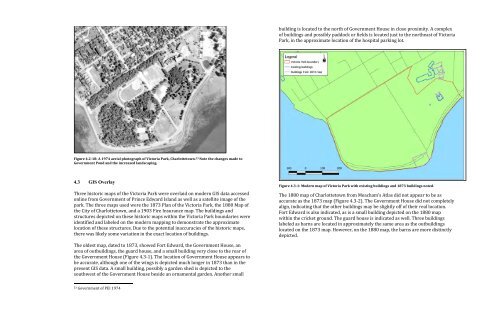
uilding"is"located"to"the"north"<strong>of</strong>"Government"House"in"close"proximity."A"complex"<br />
<strong>of</strong>"buildings"and"possibly"paddock"or"fields"is"located"just"to"the"northeast"<strong>of</strong>"<strong>Victoria</strong>"<br />
<strong>Park</strong>,"in"the"approximate"location"<strong>of</strong>"the"hospital"parking"lot."<br />
"<br />
Figure'4.2+18:'A'1974'aerial'photograph'<strong>of</strong>'<strong>Victoria</strong>'<strong>Park</strong>,'<strong>Charlottetown</strong>. 53 'Note'the'changes'made'to'<br />
Government'Pond'and'the'increased'landscaping.'<br />
"<br />
4.3 GIS Overlay<br />
"<br />
Three"historic"maps"<strong>of</strong>"the"<strong>Victoria</strong>"<strong>Park</strong>"were"overlaid"on"modern"GIS"data"accessed"<br />
online"from"Government"<strong>of</strong>"Prince"Edward"Island"as"well"as"a"satellite"image"<strong>of</strong>"the"<br />
park."The"three"maps"used"were"the"1873"Plan"<strong>of</strong>"the"<strong>Victoria</strong>"<strong>Park</strong>,"the"1880"Map"<strong>of</strong>"<br />
the"<strong>City</strong>"<strong>of</strong>"<strong>Charlottetown</strong>,"and"a"1903"Fire"Insurance"map."The"buildings"and"<br />
structures"depicted"on"these"historic"maps"within"the"<strong>Victoria</strong>"<strong>Park</strong>"boundaries"were"<br />
identified"and"labeled"on"the"modern"mapping"to"demonstrate"the"approximate"<br />
location"<strong>of</strong>"these"structures."Due"to"the"potential"inaccuracies"<strong>of</strong>"the"historic"maps,"<br />
there"was"likely"some"variation"in"the"exact"location"<strong>of</strong>"buildings."<br />
"<br />
The"oldest"map,"dated"to"1873,"showed"Fort"Edward,"the"Government"House,"an"<br />
area"<strong>of</strong>"outbuildings,"the"guard"house,"and"a"small"building"very"close"to"the"rear"<strong>of</strong>"<br />
the"Government"House"(Figure"4.3B1)."The"location"<strong>of</strong>"Government"House"appears"to"<br />
be"accurate,"although"one"<strong>of</strong>"the"wings"is"depicted"much"longer"in"1873"than"in"the"<br />
present"GIS"data."A"small"building,"possibly"a"garden"shed"is"depicted"to"the"<br />
southwest"<strong>of</strong>"the"Government"House"beside"an"ornamental"garden."Another"small"<br />
""""""""""""""""""""""""""""""""""""""""""""""""""""""""<br />
53"Government"<strong>of</strong>"PEI"1974"<br />
Davis MacIntyre & Associates Limited<br />
23<br />
"<br />
<strong>Victoria</strong> <strong>Park</strong><br />
Figure'4.3+1:'Modern'map'<strong>of</strong>'<strong>Victoria</strong>'<strong>Park</strong>'with'existing'buildings'and'1873'buildings'noted.''<br />
The"1880"map"<strong>of</strong>"<strong>Charlottetown</strong>"from"Meacham’s"Atlas"did"not"appear"to"be"as"<br />
accurate"as"the"1873"map"(Figure"4.3B2)."The"Government"House"did"not"completely"<br />
align,"indicating"that"the"other"buildings"may"be"slightly"<strong>of</strong>f"<strong>of</strong>"their"real"location."<br />
Fort"Edward"is"also"indicated,"as"is"a"small"building"depicted"on"the"1880"map"<br />
within"the"cricket"ground."The"guard"house"is"indicated"as"well."Three"buildings"<br />
labeled"as"barns"are"located"in"approximately"the"same"area"as"the"outbuildings"<br />
located"on"the"1873"map."However,"on"the"1880"map,"the"barns"are"more"distinctly"<br />
depicted."<br />
"<br />
Davis MacIntyre & Associates Limited<br />
24<br />
<strong>Victoria</strong> <strong>Park</strong><br />
"